About the GR 131 Gran Canaria

Canary Islands
country
Spain
length
91 km(57 mi)
Type of trail
Long-distance, Thru-hike
difficulty

Difficulty is highly personal. Be aware of the weather conditions as bad weather turns easier trails in difficult trails especially in the mountains.

Difficult
accommodation

Lodging means a mix of hotels, hostels or AirBnB’s.

Lodging
Elevation gain
3640 m(11942 ft)
terrain
Mountains, Coastal, Forest
remoteness
Some of the time
Show more

The GR131 on Gran Canaria is a special way to see this popular destination. The trail goes across the island over 90 kilometers, from Maspalomas in the south to Agaete in the northwest. You will see the valleys and mountains that make up the heart of this beautiful region, as well as see small villages, eat local cuisine, and meet the people who live here year round.

The trail takes you through distinct ecosystems on each day of the trek. From arid desert to quiet pine forests and rolling green hills, this island hike has it all. It even follows Gran Canaria’s Camino de Santiago route for two stages!

women in blue smiling at camera
Editor

Katie Mitchell

After a whirlwind 10 years on the road (and trail!), Katie has hiked the Camino Frances, the Peaks of the Balkans, the Fisherman’s Trail, the Cumbria Way, the Pembrokeshire Way, and more in Europe and the United States. She is an avid trail runner and you can find her either on the trail or in a cafe in a new city, sampling all of their gluten-free treats. You can follow her adventures on Instagram.

View profile

The Trail

The first stage of the GR 131 Gran Canaria is from Maspalomas to Ayagaures over about 18 kilometers. Maspalomas is a fantastic place to stock up on groceries and eat one last big meal before you head out. The first ten kilometers will be spent exiting the city and the surrounding suburbs. It also follows the Camino de Santiago route on the island, which means you may have the company of some pilgrims as you walk (although it isn’t so popular). Once you exit the city, you will stay on the road as you walk toward your destination for the evening. In all honesty, this stage is not shaded and can be loud with the noise of cars. If you are not a purist, it may be worth skipping ahead with a taxi so you can enjoy proper trails from Ayagaures onward. If you are a purist and are up for the challenge, this is a great time to reflect and see the landscape change as you make your way toward the interior of the island.

Stage two from Ayagaures is where the trail begins to pick up. You will hike toward Tunte (San Bartolomé de Tirajana) for about 16 kilometers on well-maintained paths and mountain trails as you ascend about 800 meters to a total height of 1200 meters. The trail has a little more shade than the prior day and amazing views as you climb higher and higher. Because the best time to hike the trail is in early spring, you will hopefully see lots of wildflowers as you hike as well! And while the climb is strenuous at points, there are plenty of resting spots available in the form of flat boulders and shady trees. Once you climb to the top of the Degollada de la Manzanilla at 1188 meters, you will descend for about 300 meters until you reach the sweet town of Tunte. It is tucked into the mountains and built on very steep roads with a twisting and turning network of neighborhoods where it is easy to get lost in the beautiful Spanish architecture. It is absolutely charming.

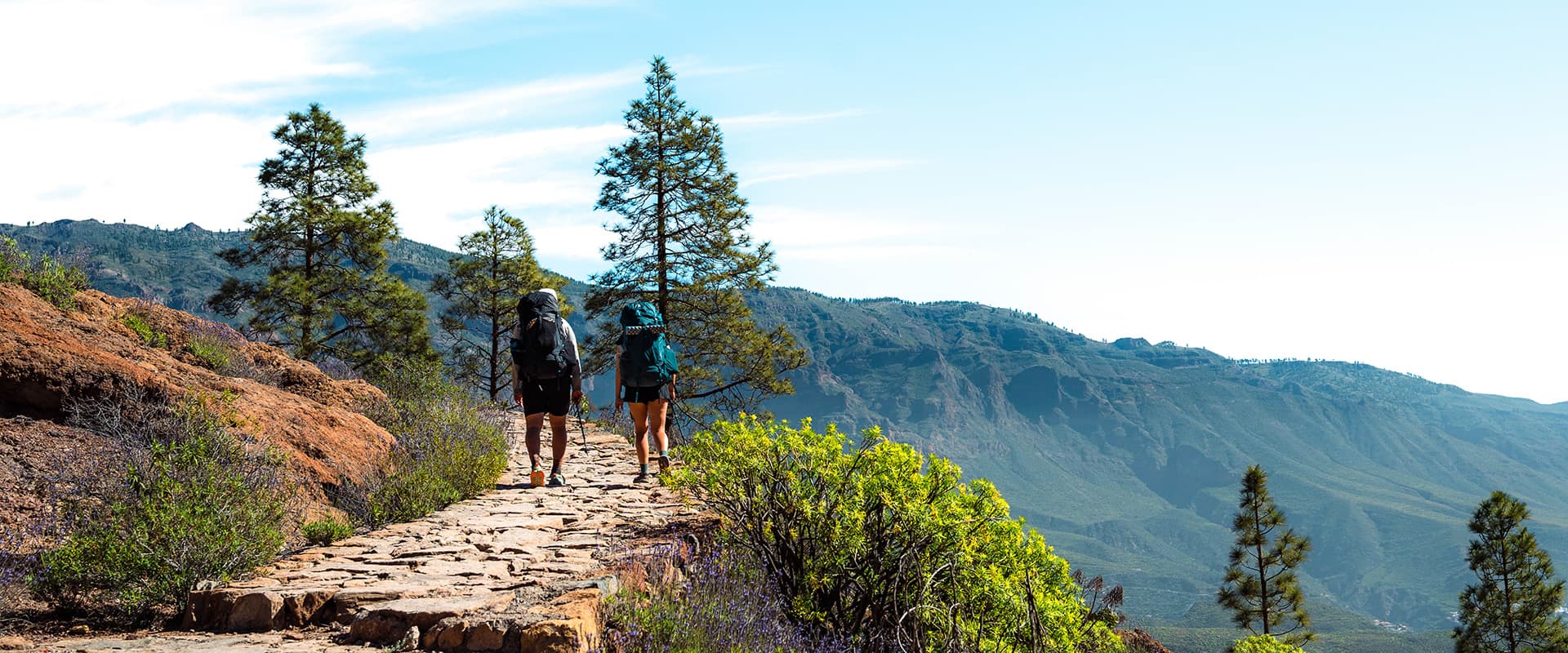
After a coffee in the main square, you will leave Tunte and hike right back up the steep roads of the town. The trail during the first half of the day will be steep inclines, although with beautifully maintained paths. For about 3 hours, you will climb 800 meters until you reach pine forests and the path mellows out to flat plateaus and small hills. But on that ascent, you will have a variety of types of trail: from cobbled path to forest and even to beautiful switchbacks that weave through some rocky peaks. It definitely keeps it interesting! Then, you will have about 7 kilometers of more gentle gradients and fantastic views of the valley from the ridges. You will have one final ascent and descent until you reach Cruz de Tejeda, your stopping point, which is (self-proclaimed?) one of the most beautiful towns in Spain. And they’re not wrong! This tiny village has great charm and is one of the most stunning places to watch the sunset over the rock formations on the horizon.

Once you pack up in Cruz de Tejeda and hit the trail, you will immediately start climbing uphill. However, unlike the previous days, this will not last long. You will hike the nearby peak (a few hundred meters) and then begin a leisurely day on rolling paths through pine forests and ridges. You will still have some climbs and descents, but they are not extremely demanding and can be done comfortably. After about 7 kilometers, you will reach Artenara, a “pueblo magico” on the island, where you can stop for coffee and a lunch. It also has a small Spar where you can fill up on water for the last section and a half of the hike. This will be your last village before the finish point of Agaete. Once you leave town, you will hike in the direction of Tamadaba. There is a recreation area here where it’s possible to camp, which is a great option if you’re wanting to experience Gran Canaria in this way. And if you want to stay in accommodations, you can arrange a taxi to pick you up here, take you to your hotel, and drop you back off at Tamadaba in the morning.

From the forests of Tamadaba on the morning of stage five, you will hike about 10 kilometers on a relatively easy descent down to Agaete. The trail is quite beautiful as you make your way on gentle paths through forests that eventually give away to  mountain ridges. There are still a few steep sections that you will need hiking poles for, but otherwise it is a gentle, hilly return back to civilization. Once you arrive in Agaete, you will walk to the old town along the water and finish your hike! Treat yourself to an ice cream and enjoy the view from the beach as a reward for this great effort.

Stages

As of February 2026, the Gran Canaria section of the GR 131 is not listed on the official Caminos Naturales website. Because of this, these stages have been compiled based on trip reports and our own time on the island. They represent the most natural breaks where you can find accommodation and water each day.

Additionally, the first stage from Maspalomas to Ayagaures can be skipped by taxi if you need to save time, as the entirety of the trail is in the city and on the main road as you leave the city.

5-stages itinerary

Stage 1:

Maspalomas – Ayagaures, 18 km | 11.2 mi

Stage 2:

Ayagaures – Tunte (San Bartolomé de Tirajana), 16 km | 10 mi

Stage 3:

Tunte (San Bartolomé de Tirajana) – Cruz de Tejeda, 15 km | 9.3 mi

Stage 4:

Cruz de Tejeda – Tamadaba, 17 km | 10.6 mi

Stage 5:

Tamadaba – Agaete, 12 km | 7.5 mi

Accommodations

Accommodation on the GR 131 Gran Canaria can be tricky, as there are not many options. It is illegal to wild camp, and there are not many places to wild camp even if you wanted to, as the trail follows steep, plunging cliffs for the most part. There is one legal camping place, at Tamadaba Recreation Area, that you do not need to book ahead of time. However, as there is only one camping place, it is likely best to stay in accommodations to save you from carrying camping gear for just one night. These can be found for the most part in the towns at the end of each stage, or nearby. If there are no accommodations available on Booking.com, it is helpful to go to Google Maps and search there. Many hotels are not listed on Booking, but can be reserved with a phone call. Additionally, we had good luck with Airbnb.

There are no accommodation options in Ayagaures and Tamadaba. It is recommended to actually begin the hike in Ayagaures to skip the road walking of the first 18 kilometers, which makes this one less of an issue. For Tamadaba, you can either camp at the Recreation Area or take a taxi to a nearby accommodation you book and return by taxi in the morning to continue your hike. It is important to note that bookings should be made early and far in advance of your trek. With so few options and it being such a popular destination, the hotels and Airbnbs can get booked out very quickly.

Best time of the year

The best time of the year to hike the GR 131 Gran Canaria is between November – March. This is when the weather is coolest and most reasonable/safe for hiking. In the summers, it is common for the temperature to reach 40°C+, which is unsafe to hike in, especially when there is so little shade and so few water resources. In the winter and early spring, the temperatures are comfortable, although still hot, between 15°-25°C. That makes this a perfect first hike of the season, or just a great escape from European winters.

Safety & Gear

To prepare for the GR 131 Gran Canaria, it is important to have a good plan for your water. You will be able to fill up at your accommodation each night and at some villages along the way, but will still need to carry 2.5-3 liters most days, as the majority of the trail is exposed and hot.

Additionally, it is smart to pack lots of sun protection for the GR 131. This means bringing a sun hoody, lots of sunscreen, sun glasses, and a good hat. You will also need shoes with good grip (trail running shoes will be better than boots), and hiking poles for the steep climbs and descents.

You are never too far from civilization, as the island is well-connected by roads. However, it is always prudent to tell someone your itinerary and check-in with that person as you hike.

Difficulty

The GR 131 in Gran Canaria is a difficult trail. We list it as difficult because of the steep ascents and descents that make up the second and third days, which require stamina and fitness to complete. Additionally, the trail is exposed and hot, which adds a layer of strain to the hiking itself. Finally, the paths are occasionally composed of loose stones and gravel on descents which can be tricky for balance and cause injuries if not careful.

Good to know

The GR 131 Gran Canaria follows the Camino de Santiago on the island for the first two stages, until Tunte. You will be okay following the Camino signage up until that point. After Tunte, you will need to keep an eye out for the GR 131 signs specifically, as there are a few other GR’s that will show up on the sign posts with the same red and white marker.

Gran Canaria is well connected with buses, and when the buses aren’t available, you can take a taxi for a reasonable price to wherever you need to go. People are friendly and will help you with the number of taxis if you need one as well.

Want to submit a trail or make this page more complete?

Always read the disclaimer

Terms of Use: important to all visitors on this website. We strive to publish high quality content and information on this website. However it’s always possible that we’re missing out on some crucial information. In spite of the fact that this route, associated GPS track (GPX and maps) were prepared under diligent research by the specified contributor and/or contributors, the accuracy of such and judgement of the author is not guaranteed. Therefore, hiking-trails.com and contributors are in no way liable for personal injury, damage to personal property, or any other such situation that might happen to individuals hiking or following this route. Should you choose to hike this trail, this is always at your own risk. Check out our guidelines for safety hiking and Leave No Trace principles at the hiking 101 page.

Download GPX

Join the community!

Login or create a FREE account 😊

With an account you can:

Download GPX files

Pin trails to your wishlist

Mark trails as hiked by you

Rate hiking trails

Comment on trails, blogs and gear reviews

Happy trails!
Login

Don't have an account yet? Register here