About the Pindos Horse Shoe Trail

country
Greece
length
51 km(32 mi)
Type of trail
Long-distance
difficulty

Difficulty is highly personal. Be aware of the weather conditions as bad weather turns easier trails in difficult trails especially in the mountains.

Moderate
accommodation

Lodging means a mix of hotels, hostels or AirBnB’s.

Lodging, Mountain huts, Wild camping
Elevation gain
3190 m(10466 ft)
terrain
Mountains
remoteness
Some of the time
Show more

In the north-west of Greece, one can find the Pindos Mountains, one of the best-kept secrets in the hiking world. Here, you’ll see the Vikos Gorge, with a depth of 1600 meters, which can be found in the Guinness Book of Records as the world’s deepest gorge. There are monasteries that you can visit, such as the Agias Paraskevis, and several bridges typical of this region.

If you’re searching for a long-distance trail in Greece without the swarms of tourists characteristic of many other regions, this may be the trail for you. It is possible late into the season, October, and the trail is welcoming to most skill levels.

Yzn ovan Zanten

Ynzo van Zanten

Ynzo is a newbie Dutch hiker with a bad case of gadget-ritis, so it’s advisable not to start talking about newly released ultralight hiking gear. It might cost you the rest of your day. His big, hairy goal is to thru-hike the PCT in a few years.

View profile

The Trail

The Pindos Horse Shoe gets its name from the fact that it starts in Monodendri and ends in the town of Vradetho, giving the trail a horseshoe shape. But when we hiked it, we simply made it into the Pindos Circle and ended up back in Monodendri to pick up our rental car (which can be parked at the edge of town without a problem).

The first day on trail will take you from Monodendri down the side of the slope of the gorge on endless switchbacks, an immediate test of your knees. Hiking poles are definitely recommended for this bit. The descent will go through dense trees toward a dry bedding of huge boulders, where you are immediately treated with amazing views of rugged mountains and bright blue skies. This beauty can only be matched by the ponds and flowing rivers of emerald blue at some parts, where the water emerges. An icy dip for the not-so-faint-hearted is an option here. Continuing onwards through the bottom of the gorge, there is another steep but very doable path towards the town of Vikos at the end of the gorge. This is a great little place to catch your breath, buy a drink or a meal, and perhaps stay for your first night.

Wild camping is not legally allowed on the trail, but is tolerated when Leave No Trace principles are practiced. For that first night, we spotted a few camp spots next to a small ruin, near the river, and near a small lake where day hikers coming from Vikos take an icy dip. Once the day hikers are gone, this is an amazing place to camp.

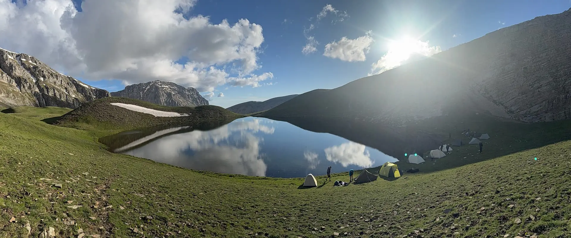
The second day, you can choose to hike into the town of Papingo, or stay a bit lower to grab coffee in Mikro Papingo, which you pass through anyhow. Here, you will leave the trees behind for a more rugged and clear landscape as you go higher into the mountains. In high season, you can choose to stay at the Astraka Refuge or get a bite to eat there. If the time allows it, keep going towards the lake on top of the mountain called Dragon Lake. It gets its name from the tiny dragonlike black lizards that can be found there, and it is a great view. However, there is no swimming allowed in this lake, as it is protected.

On the far end of the lake, there are some relatively flat spots for potential wild camping. Or, you can return to the refuge for the night. Just be sure to stock up on some water before the climb to the lake, since you are not supposed to touch the water in any way.

On the third day, either coming from the refuge or Dragon Lake, it is a beautiful descent down lush meadows with millions of beautiful flowers (in high season). Then from there, it is easy walking towards the town of Tsepolovo, where one can find places to stay and enough options for lunch or dinner.

On the fourth and final day, you can choose to visit the Vradetho steps, end up in Vradetho, or hike on towards Monodendri, which takes you back to the start of the trail. To do this, you’ll head back up the side of the Vikos gorge for a last sweat. This southern part of the trail can easily be extended, even by a few days, due to the villages and sidetrails one can find here.

Stages

By taking variants on the southern end of the trail, you can easily make this into a 5-, 6-, or 7-day hike. Our version, though, requires a minimum of 4 days. The itinerary below makes a loop instead of a horseshoe. This is helpful if you’re dealing with car drop-offs.

4-day itinerary of the Pindos Horse Shoe Trail

Stage 1:

Monodendri – Vikos, 14.2 km | 9 mi

Stage 2:

Vikos – Astraka Refuge, or Dragon Lake, 14 km | 9 mi

Stage 3:

Dragon Lake – Tsepelovo, 14.3 km | 9 mi

Stage 4:

Tsepelovo – Monodendri, 9.1 km | 5,7 mi

Accommodations

When hiking this trail, you can choose to find and book some local hotels in Vikos and Tsepolovo, and the refuge on day two, or take a tent and wild camp. Or a combination, like we did.

Wild camping is illegal in Greece, but occasionally tolerated when practiced using the Leave No Trace principles. Set up camp after dark and leave before sunrise to be stealthy.

Best time of the year

The best time of the year to hike the Pindos Horse Shoe is between May and October. In spring, the rivers might still be a bit more active, and you could run into some snow. We had no problems whatsoever towards the end of May, but it will be smart to check the opening season of the Astraka Refuge, in case you need to stay there.

Safety & Gear

Keep in mind that the weather in the high mountains can change rapidly, and it’s important to be prepared for all conditions, including rain or snow. Always check trail conditions and local weather forecasts. We brought full camping gear, including water filters, just in case.

After our flight, it was a bit tricky to find gas cannisters, so you might want to look into your options there. Ioannina is probably the best town to find them. You can also have them delivered by mail to a hotel beforehand.

Difficulty

The trail has some steep ascents and descents, and had us catching our breath now and then, but is definitely doable for the average hiker. And with a tent, you can be a bit more flexible on whether you choose to push on the tough sections or not.

Good to know

The nearest airport is the one near Lefkas, at Preveza. That is about a two-hour drive from Monodendri. The other option would be Thessaloniki, about a four-hour drive. Between Preveza and the start of the trail, the last relatively big town is Ioannina. Here you can find some stores for last-minute gear.

The host of our hotel there had some gas cannisters delivered for us, and they were ready in our room when we arrived, since we were unable to find any in town when we asked around by email before our trip.

route
Circuit
highest point
2.000m (6.561 ft)

Want to submit a trail or make this page more complete?

Always read the disclaimer

Terms of Use: important to all visitors on this website. We strive to publish high quality content and information on this website. However it’s always possible that we’re missing out on some crucial information. In spite of the fact that this route, associated GPS track (GPX and maps) were prepared under diligent research by the specified contributor and/or contributors, the accuracy of such and judgement of the author is not guaranteed. Therefore, hiking-trails.com and contributors are in no way liable for personal injury, damage to personal property, or any other such situation that might happen to individuals hiking or following this route. Should you choose to hike this trail, this is always at your own risk. Check out our guidelines for safety hiking and Leave No Trace principles at the hiking 101 page.

Download GPX

Join the community!

Login or create a FREE account 😊

With an account you can:

Download GPX files

Pin trails to your wishlist

Mark trails as hiked by you

Rate hiking trails

Comment on trails, blogs and gear reviews

Happy trails!
Login

Don't have an account yet? Register here