About the PR 9 Levada do Caldeirão

Madeira
country
Portugal
length
17 km(11 mi)
Type of trail
Day hike
difficulty

Difficulty is highly personal. Be aware of the weather conditions as bad weather turns easier trails in difficult trails especially in the mountains.

Moderate
accommodation

Lodging means a mix of hotels, hostels or AirBnB’s.

Lodging
Elevation gain
700 m(2297 ft)
terrain
Mountains, Forest
remoteness
Most of the time
Show more

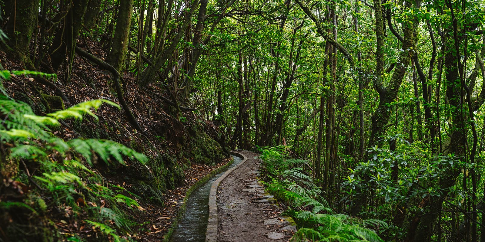
This is one of Madeira’s best day hiking trails. The PR 9 Levada do Caldeirão Verde is an incredibly beautiful levada walk in the heart of the Madeira mountains that follows a historic irrigation channel through the forested mountain slopes and along the steep terrain that maks Madeira so famous. However, the path is mostly flat and there is a clear endpoint at Caldeirão Verde. This trail is currently closed and might reopen in 2026. Please keep an eye on our Instagram account where we share the latest updates. 

This route is less popular than the PR 1 and PR 6, but for hikers who want to escape the crowds, it’s one of the best options. The route goes out and back and takes approximately 6.5 hours in total, but is never boring with the diversity of the trails, including tunnels, panoramic views, and all the levadas. We highly recommend this trail for when you’re hiking on Madeira.

Elmar profile picture
Editor

Elmar Teegelbeckers

Passionate hiker Elmar spends months of his time on the trail. He’s usually on the lookout for hidden gems in one of his favourite countries such as Slovenia, Switzerland and Japan. He founded hiking-trails.com in need for a community and detailed information about the trails. Before this, he worked for the Alpine asscociation in the Netherlands[ (NKBV) but lost his heart to the trails.

Not long ago, Elmar published the book (in Dutch) Hiking Trails – best long-distance trails in Europe. With this book, website and socials, he hopes to inspire and shape an inclusive community for hikers all over world. No matter your speed, experience or level, you can get out there to enjoy the trails and connect with the heartwarming hiking community. Life is so much better outside and he hopes to inspire hikers to take their first, or next, step on the trail.

You can reach Elmar at info@hiking-trails.com.

View profile

The Trail

The trail starts at the Casa de Abrigo das Queimadas in the Queimadas Forest Park. This shelter is built in the traditional style of the Casas de Santana, with a triangular shape and a thatched roof. It is an easy-to-find and practical starting point, with clear trail signage.

From here, the path follows the levada almost immediately, with little height difference over the first section. Soon after the start, you reach the terrace of Levada do Caldeirão Verde. The trail runs through Laurissilva forest, a protected forest that is characteristic of Madeira. Water flows continuously through the levada, which was constructed in the 18th century to supply water to farmlands in the parish of Faial. The path remains narrow in places but is generally well-maintained and easy to follow.

Further along the route, the terrain becomes steeper and more exposed. The levada is cut into the mountainside, with drops on one side and rock walls on the other. Along the way, you pass through four tunnels carved into the rock. These tunnels are dark and can be wet, so a headlamp or torch is necessary. While the trail is classified as moderate, care is needed in these sections, especially in wet conditions. The path is very narrow here, so you will need to pay attention as you walk.

After the tunnels, the trail reaches Caldeirão Verde. It is likely that you will experience different weather on each side of the tunnels, as they take you to different sides of the mountain. On the left side of the path, a waterfall drops from the Ribeiro do Caldeirão Verde into a small lake below. The waterfall has a drop of about 100 metres and is the main destination of the hike. This is the usual turning point for the walk. Most people then return to Queimadas via the same route.

However, from Caldeirão Verde, it is possible to continue to Caldeirão do Inferno. This extension is longer and more demanding and should only be considered if time, weather, and trail conditions allow. If you’re looking for a multi-day hike on Madeira, check out the Madeira Crossing.

Best time of the year

The best time to hike the PR 9 is in spring and autumn. Madeira is a great destination for year-round hiking, although spring and early autumn are considered the best months with the most stable weather conditions for mountain hiking. Although be careful, it can be rainy and windy at all times on Madeira, as this island is situated in the middle of the ocean. If it’s bad and stormy weather, don’t go out on the hiking trails and choose another day. Safety first.

Safety & Gear

While hiking on Madeira, a few things are important for your safety and gear. First of all, keep the unpredictable weather conditions in mind. You’re in the middle of the Atlantic Ocean, and the weather can shift quickly from nice sunny weather to sudden rainstorms. Always bring high-quality rain gear, such as a hardshell rain jacket and rain pants. Also, bring enough layers if it might get cold, especially in the mountains.

The trails and especially the wet stairs and levadas can be slippery. Bring sturdy hiking shoes with good grip. Additionally, you can bring hiking poles for extra stability. Last, bring enough water and snacks. This is a long trail, and you should be adequately hydrating throughout your hike.

Difficulty

The trail is rated as moderate, although it always depends on your stamina and weather conditions. Rain can make the paths and levadas slippery, so be careful and wear shoes with good grip. No sneakers!

Good to know

Due to the weather conditions, landslides and the forest fires in Madeira in August 2024, some trails are currently closed and being repaired. The government and trail organisations have officially announced that most trails might re-open around April 2026, if everything goes according to plan. Please keep an eye on our Instagram account, where we are sharing the latest updates about the hiking trails in Madeira. 

Also important: you will need a permit for the PR 9, which you can reserve on the SIMplifica website. This is a popular trail, so make sure you book the permit slots in advance.

route
Out and back
highest point
1020m (3346 ft)

Guidebooks

cover of guidebook on hiking in Madeira

Guidebook: hiking in Madeira

View guidebook

Want to submit a trail or make this page more complete?

Always read the disclaimer

Terms of Use: important to all visitors on this website. We strive to publish high quality content and information on this website. However it’s always possible that we’re missing out on some crucial information. In spite of the fact that this route, associated GPS track (GPX and maps) were prepared under diligent research by the specified contributor and/or contributors, the accuracy of such and judgement of the author is not guaranteed. Therefore, hiking-trails.com and contributors are in no way liable for personal injury, damage to personal property, or any other such situation that might happen to individuals hiking or following this route. Should you choose to hike this trail, this is always at your own risk. Check out our guidelines for safety hiking and Leave No Trace principles at the hiking 101 page.

Download GPX

Join the community!

Login or create a FREE account 😊

With an account you can:

Download GPX files

Pin trails to your wishlist

Mark trails as hiked by you

Rate hiking trails

Comment on trails, blogs and gear reviews

Happy trails!
Login

Don't have an account yet? Register here