About the Adlerweg

Alps
country
Austria
length
332 km(206 mi)
Type of trail
Long-distance, Hut to hut
difficulty

Difficulty is highly personal. Be aware of the weather conditions as bad weather turns easier trails in difficult trails especially in the mountains.

Difficult
accommodation

Lodging means a mix of hotels, hostels or AirBnB’s.

Mountain huts, Lodging
Elevation gain
22652 m(74318 ft)
terrain
Mountains, Forest, Hills
remoteness
Some of the time
Show more

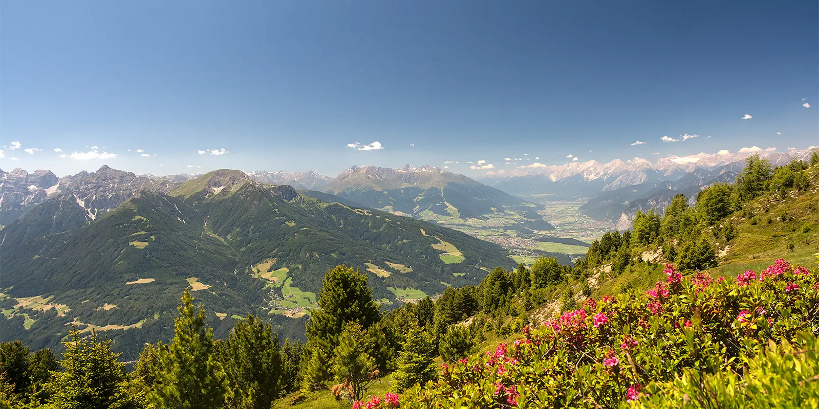
The Adlerweg, or Eagle Walk, is an iconic hiking trail in Tyrol. It’s one of the most unique long-distance hiking trails in Austria. With 24 stages and approximately 330 kilometers, the main route starts at Rummlerhof near St. Johann and ends at St. Christoph on the Arlberg Pass. The route, shaped like an eagle in flight, will show you the spectacular landscapes of the Austrian Alps. It’s also known as “The king of the long-distance hiking trails in Tyrol.”

The Adlerweg was created in 2004. At one point, the trail consisted of 126 stages. It became really popular, so everyone wanted to do (parts of) the trail, with many variations. In 2015/2016, the route was completely redesigned and provided with new trail markers. If you want to hike the complete Eagle Walk of 413 kilometers, you also have to go to East Tyrol for another 9 stages, 93 kilometers, and 8000 meters of elevation. Here, you’ll find a description of the main route of 24 stages.

profile picture Joy Hadders
Author

Joy Hadders

Joy Hadders is a Dutchie who takes full advantage of her free days off of work to experience as much as possible in other countries. Like many others, she found her way in hiking during the lockdown and now she’s also hooked! She enjoys discovering hidden gems with her boyfriend and dreams of a fully pinned world map. You can follow Joy on Instagram @joyhadders.

View profile

The Trail

Starting at Rummlerhof, the first stages will take you towards the rugged peaks of the Wilder Kaiser, the first alpine area with the Austrian hiking quality mark. This mountain range consists of two striking mountain ranges: the Wilder Kaiser and the Zahmen Kaiser. Both are located near Kufstein. You’ll hike through beautiful forested areas, past traditional alpine huts, and along ridges with beautiful views. At the Gaudeamushütte and Kaindlhütte, you can enjoy the impressive rock formations of the Kaisergebirge.

The landscape changes when you enter the Brandenberg Alps. They are also referred to as the Rofan Mountains. But, this only defines the elevations between the Brandenberger Ache River and Tyrol’s largest lake, Lake Achensee. Dramatic limestone peaks turn into green meadows now. The area of Kufstein is so beautiful! Here, you’ll ascend towards Guffertspitze and Lake Achensee, where you’ll see that the water is crystal clear which makes it a great spot to take a break (and photos).

From stage six, you’ll discover the Karwendel Mountains. The Karwendel is the largest mountain range of the Northern Limestone Alps. The biggest area is located in Austria, but a small part belongs to Germany. This mountain range is known for its deep gorges and towering cliffs. You can also find a lot of wildlife here. After the Lamsenjochhütte you are challenged by high-altitude paths. Beautiful views are guaranteed. If you want to experience the untouched Karwendel wilderness, you’re at the right place. The Falkenhütte is a great example of that, nestled beneath the impressive Laliderer Wände. Alpine meadows and rocky ridges will be next as you pass the Karwendelhaus and Hallerangerhaus before descending into Innsbruck.

In Innsbruck, you can rest and explore the historic and cultural city, before heading back to the mountains. Stage 13 is a little bit of a mystery because the route stops at stage 12 and continues with stage 14. But, stage 13 is an 8-kilometer hike that is possible to reach by a gondola, lift, and multiple buses. This stage, ‘The Zirbenweg Trail,’ starts above the Schutzhaus Patscherkofel mountain hut and leads east. Here you’ll find more information about how to get there. Eventually, you’ll go back to Innsbruck where you continue the Adlerweg at stage 14.

When you’re back at Innsbruck, you’ll ascend to Solsteinhaus, which is completely surrounded by impressive mountain peaks. Alpine meadows and charming villages in the Leutasch Valley will impress you in a different way than the rugged mountains. Continuing the stages, you’ll get amazing views of the Wetterstein Mountains and Zugspitze, Germany’s highest peak.

You’ll be treated to a steep ascent after you leave Ehrwald. Here you will find the mountain hut Lorea Hütte. After that, you will go further on rocky paths towards Anhalter Hütte where you can enjoy the views of the surrounding valleys. The following stages contain high-altitude paths. From here, you can experience the Lechtal Alps in multiple ways because you’ll stay at the Hanauer Hütte, Württemberger Haus, and Memminger Hütte.

Almost there! Starting at Memminger Hütte, you’ll hike towards Ansbacher Hütte. This next part of the Adlerweg contains dramatic ridgelines and beautiful alpine scenery. The last stage is an 18-kilometer hike from Kaiserjochhaus to St. Christoph am Arlberg. Here you’ll experience a historic mountain pass.

Whether tackling the main 24 stages, the full 33 stages, or selecting individual sections, The Eagle Walk is full of challenging paths, rewarding views, and traditional mountain hut vibes.

Stages

Many different sources communicate that The Eagle Walk is 413 km in 33 stages. But the main route is 24 stages with a total of 332 kilometers. The fact is that a second, small eagle flies in East Tyrol. The southern part of the Adlerweg has been set out there and here you will find 9 stages, with a total of 93 kilometers and 8000 meters of elevation.

Adlerweg 24-stage itinerary

Stage 1:

Rummlerhof – Gaudeamushütte, 13 km | 8 mi

Stage 2:

Gaudeamushütte – Kaindlhütte, 15 km | 9.3 mi

Stage 3:

Kaindlhütte – Kufstein, 13 km | 8 mi

Stage 4:

Kufstein – Gasthof Buchacker, 11 km | 6.8 mi

Stage 5:

Gasthof Buchacker – Gasthof Gwercherwirt, 18 km | 11.2 mi

Stage 6:

Gasthof Gwercherwirt – Gasthof Waldhäusl, 18 km | 11.2 mi

Stage 7:

Gasthof Waldhäusl – Erfurter Hütte, 18 km | 11.2 mi

Stage 8:

Erfurter Hütte – Lamsenjochhütte, 17 km | 10,6 mi

Stage 9:

Lamsenjochhütte – Falkenhütte, 13 km | 8 mi

Stage 10:

Falkenhütte – Karwendelhaus, 9 km | 5.6 mi

Stage 11:

Karwendelhaus – Hallerangerhaus, 14 km | 8.7 mi

Stage 12:

Hallerangerhaus – Innsbruck, 13 km | 8 mi

Stage 13:

Innsbruck – Zirbenweg – Innsbruck, 8 km | 5 mi (more information)

Stage 14:

Innsbruck – Solsteinhaus, 7 km | 4.3 mi

Stage 15:

Solsteinhaus – Leutasch/Ahrn, 20 km | 12.4 mi

Stage 16:

Leutasch/Ahrn – Ehrwald, 23 km | 14.3 mi

Stage 17:

Ehrwald – Lorea Hütte, 19 km | 11.8 mi

Stage 18:

Lorea Hütte – Anhalter Hütte, 16 km | 10 mi

Stage 19:

Anhalter Hütte – Hanauer Hütte, 12 km | 7.5 mi

Stage 20:

Hanauer Hütte – Württemberger Haus, 11 km | 6.8 mi

Stage 21:

Württemberger Haus – Memminger Hütte, 7 km | 4.3 mi

Stage 22:

Memminger Hütte – Ansbacher Hütte, 10 km | 6 mi

Stage 23:

Ansbacher Hütte – Kaiserjochhaus, 9 km | 5.6 mi

Stage 24:

Kaiserjochhaus – St. Christoph am Arlberg, 18 km | 11.2 mi

Accommodations

When hiking this trail, you’ll mainly stay in one of the mountain huts alongside the trail. At some stages, you’ll be in a small village, or Innsbruck for example. There you can find multiple options to stay the night.

At most of the stages, the end is a mountain hut, but if you want to know more about accommodation options along this trail and the surrounding area, you can find more information here. 

Best time of the year

The best time of the year to hike The Eagle Walk is from June to (early) September. As you’re hiking in the mountains, be aware that there might be snowfields in early summer and there might be early snowfalls in late summer and early autumn. Generally, the hiking season in the European Alps is limited to the summer months when the weather is milder and the snow has melted, making the trails accessible.

Keep in mind that the weather in the high mountains can change rapidly, and it’s important to be prepared for all conditions, including rain or snow. Always check trail conditions and local weather forecasts before starting a high-alpine hike. Additionally, consider your hiking experience and skill level, as some trails in the high Alps can be challenging and require proper equipment and experience.

Safety & Gear

Because it’s a high-altitude trail, it’s necessary to prepare yourself properly. You have to be experienced in hiking long distances, you have to deal with altitudes, and you need a good fitness level.

A lightweight backpack (30 – 40 liters) is ideal for carrying all your supplies, including snacks, water and extra clothing. There will be enough water resources during the trail, but it’s recommended to bring enough water with you for a full day (at least 2 liters) because of the distances, elevation meters, and possible temperature changes.

Essential gear includes sturdy hiking boots with good grip, a detailed map or GPX or GPS device, and weather-appropriate clothing.

In this area, you can experience rapid weather changes (sunshine can quickly turn into rain or fog), so first of all: check the forecast daily. Second: bring a waterproof jacket and layers for different temperatures. Hiking poles can help with balance on steep or uneven terrain.

Difficulty

The Adlerweg is rated as difficult because the trail contains a couple of long stages, much elevation gain, and rocky ridges. This trail is well-marked, but it’s a high-altitude trail. You’ll experience steep ascents, rocky sections, and (exposed) ridges, which require a good sense of balance and no fear of heights. Because of the significant elevation changes, you definitely need a solid hiking background and proper preparation for this trail.

Good to know

(Parts of) The Adlerweg is very popular among hikers all over the world. Make sure you book the mountain huts and hotels a few months in advance to secure your spots each night. Most huts can be booked by sending them an email or applying on their website.

Stage 13 is maybe a little bit confusing because the trail is interrupted between 12 and 14, so to speak. After stage 12 you have to go to Zirbenweg for another 8 kilometers and eventually go back to Innsbruck to continue with stages 14-24, the ‘second part’ of The Eagle Walk. Here you will find more information about how to get there.

If you want to hike the complete 413 kilometers of the Eagle Walk, you also have to go to East Tyrol for another 9 stages, 93 kilometers, and 8000 meters of elevation.

route
point-to-point
highest point
2.870m (9.416 ft)

Want to submit a trail or make this page more complete?

Always read the disclaimer

Terms of Use: important to all visitors on this website. We strive to publish high quality content and information on this website. However it’s always possible that we’re missing out on some crucial information. In spite of the fact that this route, associated GPS track (GPX and maps) were prepared under diligent research by the specified contributor and/or contributors, the accuracy of such and judgement of the author is not guaranteed. Therefore, hiking-trails.com and contributors are in no way liable for personal injury, damage to personal property, or any other such situation that might happen to individuals hiking or following this route. Should you choose to hike this trail, this is always at your own risk. Check out our guidelines for safety hiking and Leave No Trace principles at the hiking 101 page.

Download GPX

Join the community!

Login or create a FREE account 😊

With an account you can:

Download GPX files

Pin trails to your wishlist

Mark trails as hiked by you

Rate hiking trails

Comment on trails, blogs and gear reviews

Happy trails!
Login

Don't have an account yet? Register here