blue mountain lake in Swiss mountain lake near the Moiry Dam

Zinal to the Moiry Dam via Sorebois

About the Zinal to the Moiry Dam via Sorebois

Val d’Anniviers
country
Switzerland
length
19 km(12 mi)
Type of trail
Day hike
difficulty

Difficulty is highly personal. Be aware of the weather conditions as bad weather turns easier trails in difficult trails especially in the mountains.

Difficult
accommodation

Lodging means a mix of hotels, hostels or AirBnB’s.

Mountain huts, Lodging
Elevation gain
1808 m(5932 ft)
terrain
Mountains
remoteness
Some of the time
Show more

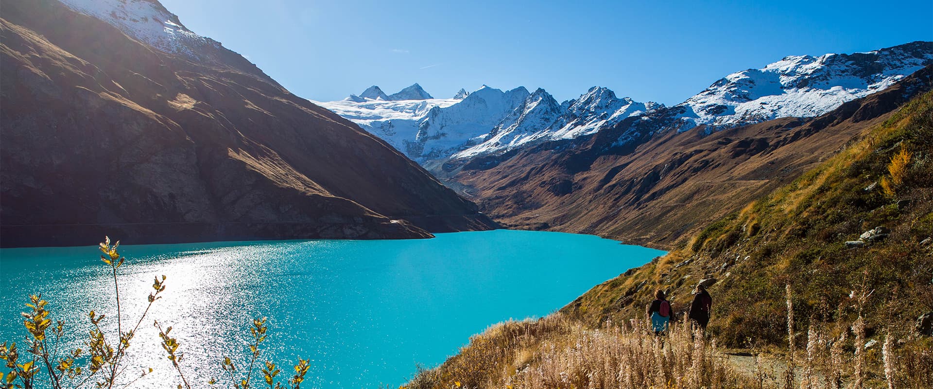
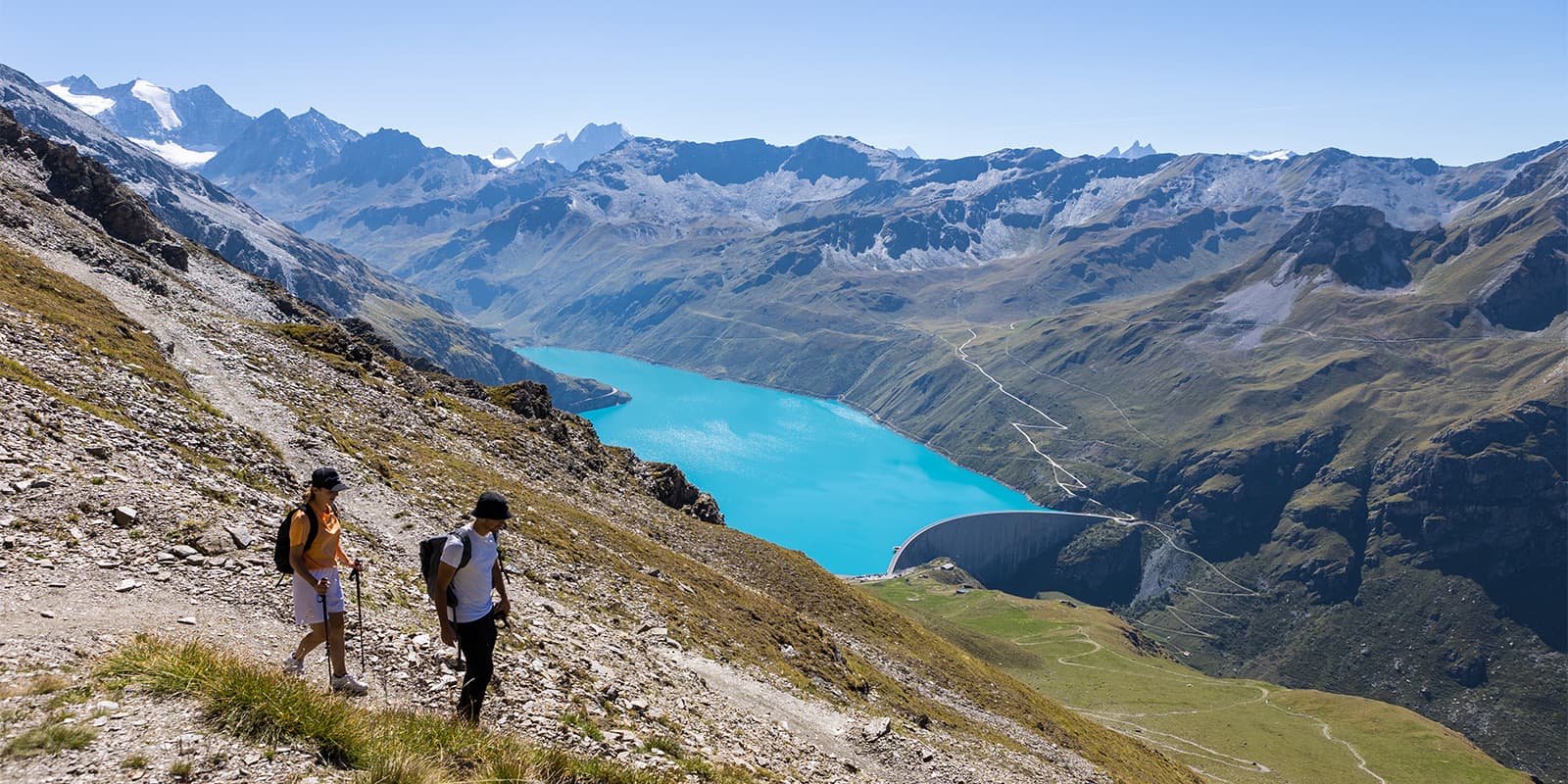
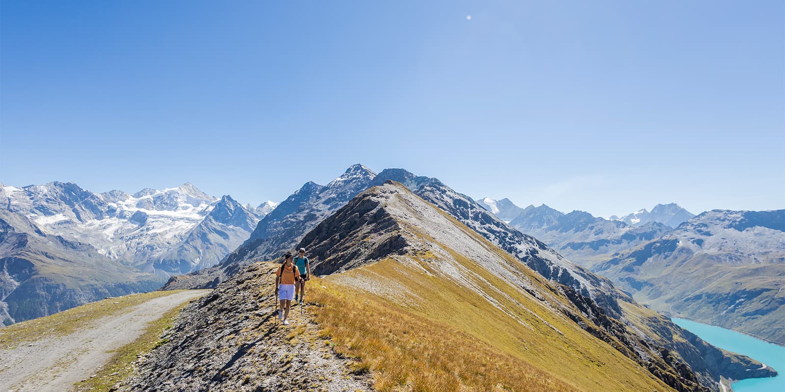
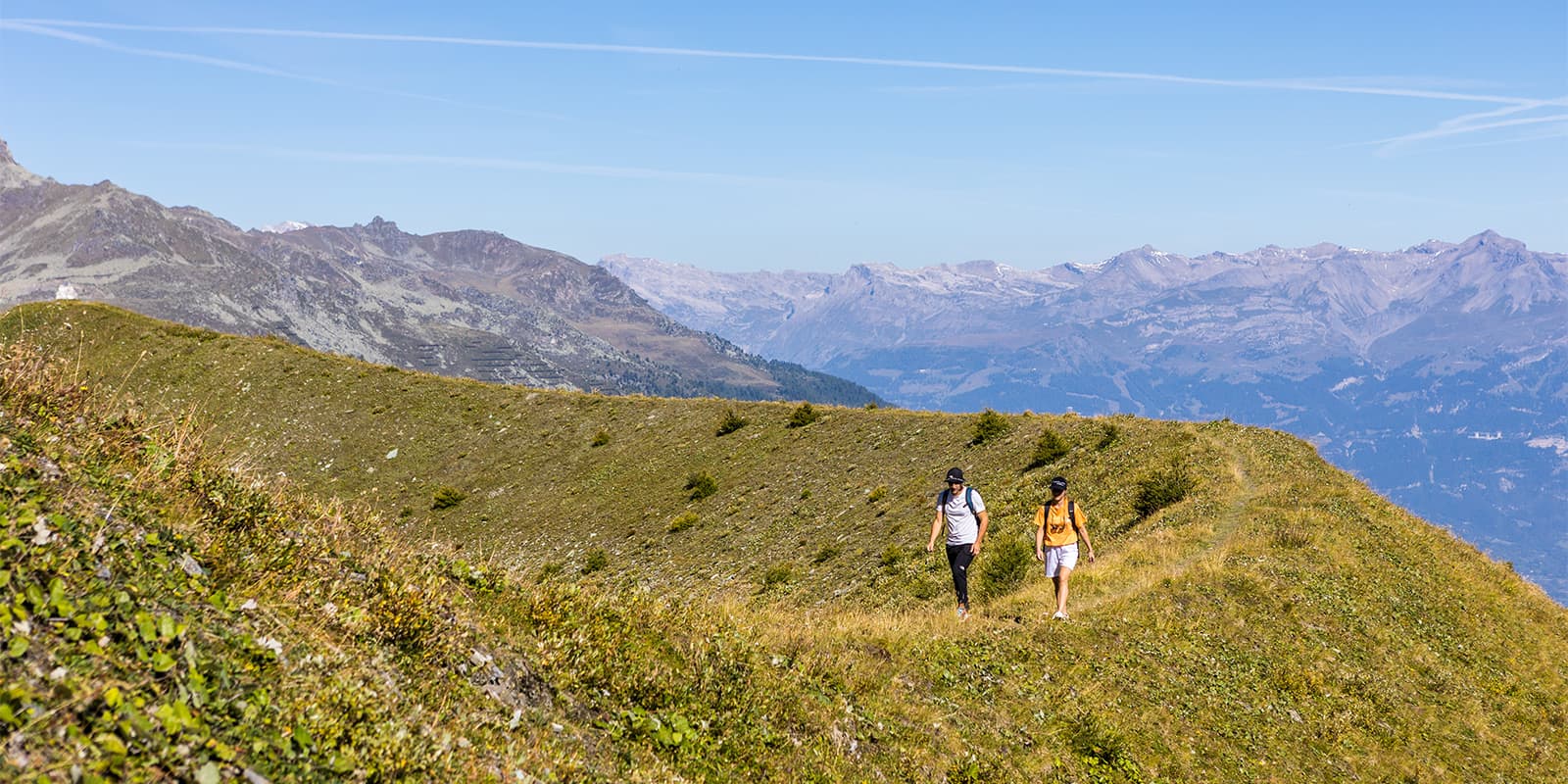
Hiking from Zinal to Moiry Dam via Sorebois is a beautiful day hike in the Valais canton. With its wide range of activities (hiking, climbing, Via Ferrata, guided tours of the dam), its restaurant, and its breathtaking scenery, the whole Moiry region has become a main destination of Anniviers. It is especially stunning in autumn.

Standing 148 meters tall, this impressive dam reigns supreme at the end of the Vallon de Moiry. From the top, a panoramic view awaits you, along with a variety of other activities and attractions to explore.

women in blue smiling at camera
Editor

Katie Mitchell

After a whirlwind of 8 years on the road (and trail!), Katie has hiked the Camino Frances, the Peaks of the Balkans, the Fisherman’s Trail, and extensively in the United States. She is an avid trail runner and now lives in Colorado where she plays in the mountains in her free time. You can follow her adventures on Instagram.

View profile

The Trail

Starting from Zinal, follow the Navizence as you make your way up the valley. Cross the Singline Bridge and follow the alpine road that passes through the Singline pasture and continues to Sorebois.

Continue your climb toward the Col de Sorebois, where you’ll be rewarded with breathtaking views of the Zinalrothorn, Weisshorn, and Dent Blanche—three of the iconic 4,000-meter peaks of the Val d’Anniviers. A short descent then leads you to the Moiry Dam, which you will follow along its entire length below.

At the trail junction, follow the signs toward the Lake of Châteaupré, then begin the final ascent toward the Moiry Hut. Your hike will conclude with a two-kilometer climb before reaching the hut, perched above the glacier and offering a spectacular view.

Stages

The tour is completed as a day hike, although there are three main sections within the day. Below you will find the three, along with an alternative to the first section, as well as an additional section you can add in the middle, the Tour du lac de Moiry, to add another 7.3 kilometers to the day.

Zinal to Moiry Hut stages

Stage 1:

Zinal – Sorebois, 5.7 km | 3.5 mi (+765m)

Option: Take the gondola from Zinal to Sorebois

Stage 2:

Sorebois – Corne de Sorebois – Moiry Dam, 5.9 km | 3.7 mi (+423m -601m)

Optional stage: Tour du lac de Moiry, 7.3 km | 4.5 mi (+100m -100m)

Stage 3:

Moiry Dam – Moiry Hut, 7.7 km | 4.8 mi  (+620m -44m)

Accommodations

This is a day hike, but you’ll still need to book accommodations on either side as it is a full day’s worth of hiking. You’ll end the hike at the Moiry hut, where you’ll likely be pretty tired. Instead of descending to the Moiry bus station to go back to the valley, it’s worth sleeping in the hut if you can reserve a bed ahead of time!

Accommodation in Zinal:

Best time of the year

There are a few considerations to keep in mind as you plan your trek from Zinal to the Moiry Dam via Sorebois. First, the trail is accessible from June to October. Second, the best time to enjoy the hike is between August and September, when there will be the best weather. Finally, the Moiry Hut is open from the 15th of June to the 15th of September. These can be helpful to keep in mind as you decide when to tackle this trek!

Safety & Gear

The trek is a day hike, but that doesn’t mean you shouldn’t prepare. You can start prepping for the hike by packing correctly: keep it light, as you’ll pass by a few restaurants for food and water along the way, but keep it smart with gear that can assist you if the weather changes or you run into difficulties. You’ll want to bring snacks and electrolytes to keep your energy and mineral levels up, as well as a water bottle to refill. For clothing, taking layers will be best, including a rain jacket, comfortable hiking shoes, and a hat to protect your face from the sun.

Finally, it can be helpful to take a first aid course before going into the alpine. Especially if you’re alone, this can be comforting to know what to do in an outdoor emergency. Taking a stocked first aid kit will help, as well!

Difficulty

Although it is a day hike, the trail between Zinal to the Moiry Dam via Sorebois can be quite difficult! You will ascend 1808 meters in one day, descending 645 meters as well. This trek is best for experienced hikers who are comfortable with long days in the mountains. You’ll want to train for this hike, as it can be difficult for the body to climb so much in one day.

Good to know

Along the trail, you’ll pass three different places where you can stop to refill your water and eat a meal. The first is in Sorbois, at the Sorebois Mountain Restaurant. Next, you’ll pass the Lake Moiry Restaurant (where you’ll have wonderful views!) and finally the Moiry Hut. It’s recommended that you sleep at the hut after your long day of hiking, to fully enjoy your time outdoors and eat a warm meal with other hikers before you descend the next day.

There is a bus station at Lake Moiry, which you will hike down to the next day. This will take you back to the valley, where you can then depart from.

route
point-to-point
highest point
2.857m (9.374 ft)

Want to submit a trail or make this page more complete?

Always read the disclaimer

Terms of Use: important to all visitors on this website. We strive to publish high quality content and information on this website. However it’s always possible that we’re missing out on some crucial information. In spite of the fact that this route, associated GPS track (GPX and maps) were prepared under diligent research by the specified contributor and/or contributors, the accuracy of such and judgement of the author is not guaranteed. Therefore, hiking-trails.com and contributors are in no way liable for personal injury, damage to personal property, or any other such situation that might happen to individuals hiking or following this route. Should you choose to hike this trail, this is always at your own risk. Check out our guidelines for safety hiking and Leave No Trace principles at the hiking 101 page.

Download GPX

Join the community!

Login or create a FREE account 😊

With an account you can:

Download GPX files

Pin trails to your wishlist

Mark trails as hiked by you

Rate hiking trails

Comment on trails, blogs and gear reviews

Happy trails!
Login

Don't have an account yet? Register here