About the Stubaier Höhenweg

Alps
country
Austria
length
80 km(50 mi)
Type of trail
Long-distance, Hut to hut
difficulty

Difficulty is highly personal. Be aware of the weather conditions as bad weather turns easier trails in difficult trails especially in the mountains.

Difficult
accommodation

Lodging means a mix of hotels, hostels or AirBnB’s.

Mountain huts
Elevation gain
5871 m(19262 ft)
terrain
Mountains, Forest
remoteness
Most of the time
Show more

The Stubaier Höhenweg is a trail that is unlike most others. Known for its incredible vistas and tough climbs, you’ll hike hut-to-hut throughout the Tyrol region for seven stages. The trail is located in the Stubai Alps quiet area, making it a peaceful place to enjoy a week off. Also awarded the mountain trail seal of quality, you won’t regret escaping into the mountains here!

You’ll enjoy getting to pick your adventure as you plan which huts to sleep at and how long you want each stage to be! The hike is known for also being an ultra trail run route, and the region is famous for its snow sports and other recreation activities.

women in blue smiling at camera
Editor

Katie Mitchell

After a whirlwind of 8 years on the road (and trail!), Katie has hiked the Camino Frances, the Peaks of the Balkans, the Fisherman’s Trail, and extensively in the United States. She is an avid trail runner and now lives in Colorado where she plays in the mountains in her free time. You can follow her adventures on Instagram.

View profile

The Trail

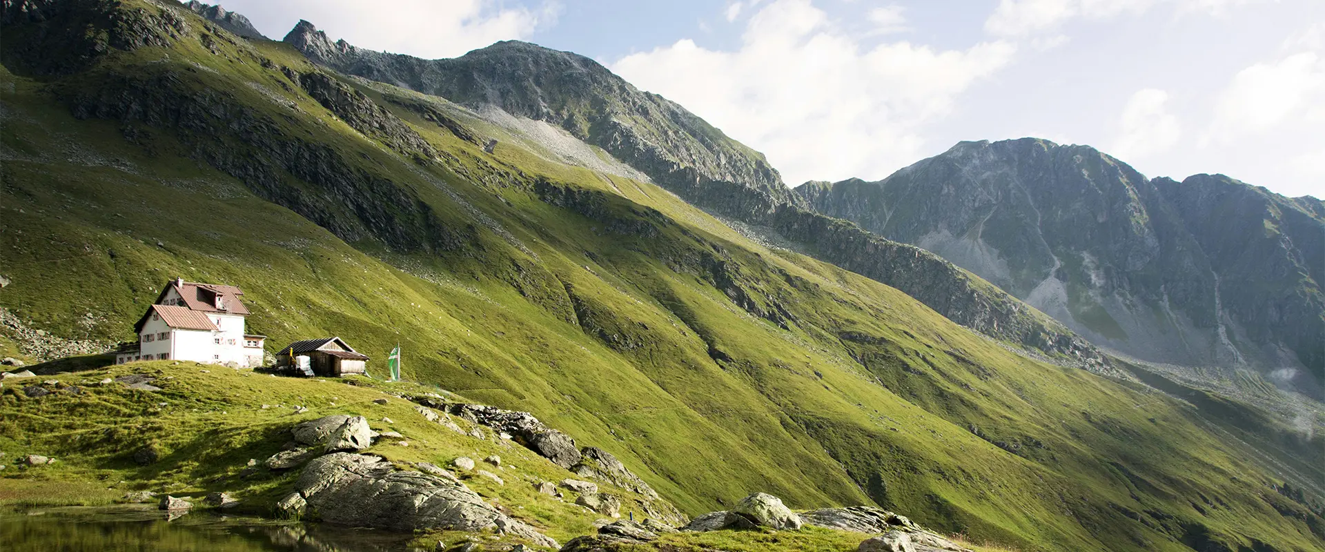
While some of the days are quite short in the original seven-stage itinerary, they are strenuous. However, if you’re confident in your abilities, there is room to combine stages as you see fit. The first stage begins at the Starkenburger Hut, which you can reach by bus from the valley. You’ll hike 15 kilometers toward the Franz-Senn-Hut. You’ll get to scramble over boulders and scree, making this already a fun adventure. The trail passes alpine lakes and will guide you down some steep, cabled, switchbacks until you reach the Rote Wand, where it should even out and you’ll be guided to a rest point at the Seducker Hochalm. From there, you’ll hike a final stretch to the Franz-Senn-hut where you’ll spend the night.

The second stage is much shorter, only 9 kilometers. This isn’t the shortest stage of the tour, yet still requires you to plan four hours. This stage is often referred to as the easiest of the tour, which is a nice break after the strenuous climbs of the day prior. You’ll start by hiking flat for a while before you quickly begin to ascend, descend, and ascend again. The trail will pass the Stubai Main Ridge on this day, which is definitely worth stopping to enjoy as you go. You’ll finally make your way down to the Neue Regensburger Hut where you’ll spend the night.

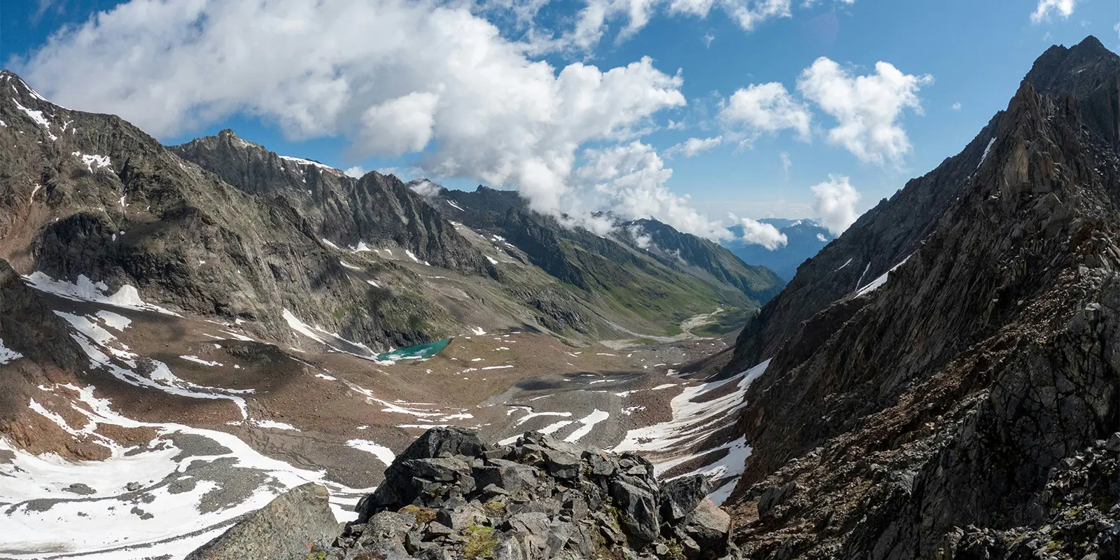
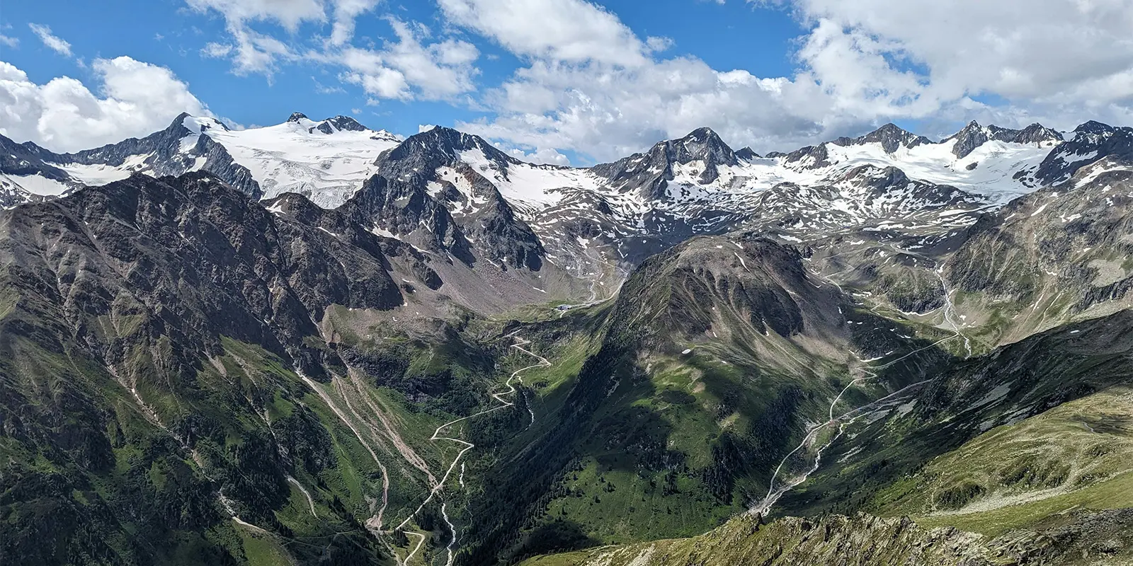
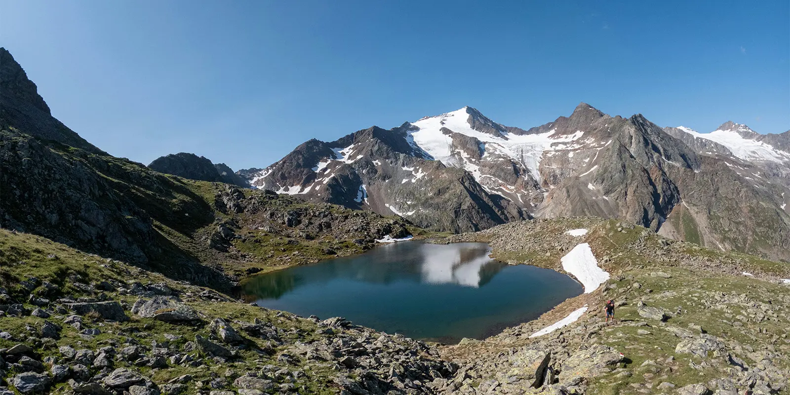
You’ll begin the third stage rested after the 9-kilometer day, ready to tackle 13 kilometers in 7 hours. This day is a big climbing day, with over 1000 meters of gain. You’ll love getting to see the glacial views throughout this hike, which you’ll be slowly approaching. The path will come near more alpine lakes, a great place to break and rest if you need it. The views and terrain are something wonderful and worth taking the time to appreciate as you go. Eventually, you’ll reach the Dresdner Hut where you’ll spend the night.

Now, stages 4, 5, and 6 are all shorter days. You’ll hike only 4, 5, and 6 kilometers each day, respectively. While there is quite a bit of climbing, it is likely that two can be combined if you’re feeling strong, which will total around 800-1000 meters of gain, depending on which two you combine. The trail on these days will pass gorgeous moraine lakes, cableways, bridges, mountain pastures, scree fields, and the potential for “side-quest summits” if you choose not to combine days.

Stage seven begins from Bremer Hut and will take you to the final destination in 9.5 kilometers. You’ll realize quickly that this is the most demanding stage of the trail, with three climbs that are each 200-300 meters. There are two routes down, one for experienced mountaineers where you’ll lower yourself using ropes and supports down a chimney above the Lauterer See. The other, “normal,” route is great for people with less mountain experience, where you will hike down below the material lift. Both routes will lead to Trauljöchl, where you’ll then ascend using ropes to the Pramarspitze. From there, you’ll climb the Sendesgrat and finally descend slightly past the Alfaier See alpine lake to the Innsbrucker Hut. This is where the tour ends and you’ll have options to descend in the valley to where your car (or other transportation) is. With that, you’ll finish an incredibly rewarding tour!

Stages

The Stubaier Höhenweg is comprised of seven stages that traverse 80 kilometers. Because of this, a few of the stages are shorter (4, 5, 6 kilometers) which means there’s potential to combine stages. However, be warned that these are not easy stages by any means and most people need the shorter stages to recover.

The below itinerary shows you the route once you’re up in the alpine, as there are multiple ways to ascend and descend to/from the valleys.

Stubaier Höhenweg 7-stage itinerary

Stage 1:

Starkenburger Hut – Franz-Senn-Hut, 15 km | 9.3 mi

Stage 2:

Franz-Senn-Hut – Neue Regensburger Hut, 9 km | 5.6 mi

Stage 3:

Neue Regensburger Hut – Dresdner Hut, 13 km | 8 mi

Stage 4:

Dresdner Hut – Sulzenau Hut, 5 km | 3.1 mi

Stage 5:

Sulzenau Hut – Nürnberger Hut, 4.4 km | 2.7 mi

Stage 6:

Nürnberger Hut – Bremer Hut, 6 km | 3.7 mi

Stage 7:

Bremer Hut – Innsbrucker Hut, 9.5 km | 5.9 mi

Accommodations

The Stubaier Höhenweg is a hut-to-hut tour, wherein you will sleep at mountain huts each night. This means sharing dormitories with fellow hikers, eating at communal tables, and getting to swap stories of adventures outside with new friends. Mountain huts are a great chance to experience the alpine culture of the region, enjoy delicious meals at the end of a tough hiking day, and rest weary legs in a beautiful, comfortable place.

Be sure to book your hut stays far in advance! Huts tend to book up quickly when reservations open, so you’ll want to secure your place in the spring. You will either book your stay on the mountain huts’ websites or by sending an email. The sites will tell you what you need to do!

Mountain huts per stage

Stage 1:

Franz-Senn-Hut

Stage 3:

Dresdner Hut

Stage 4:

Sulzenau Hut

Stage 5:

Nürnberger Hut

Stage 6:

Bremer Hut

Stage 7:

Innsbrucker Hut

Best time of the year

The best time of the year to hike the Stubaier Höhenweg is from June to September. This is when the weather will be best, the mountain huts will actually be open, and the trail will be clear. A clear, accessible trail means that lingering snow has melted and that it is safe to pass. If you’re concerned about the trail conditions, you can call the hut wardens before your hike for a live trail report.

Early in the season will have a higher chance of snow, and later in the season may start to see colder temperatures. However, July and August are the peak months when the trail will be the busiest. You’ll have the choice of how you’d like to experience the hike!

Safety & Gear

The Stubaier Höhenweg is a trail for people with experience in an alpine environment. Due to the many sections secured by cables, the exposed ridges, and the strenuous climbs, you must train for this hike! Especially if you plan to combine sections, the trail is beautiful but hard on the body. You’ll be grateful you prepared plenty ahead of time.

Make sure to bring all of the necessary gear, outlined in this helpful hut-to-hut gear list. You will also want to download the GPX offline to your device, and perhaps bring a map and compass if that’s fun for you. Finally, make sure you tell someone where you’re going and your itinerary. Update them if you switch plans last minute, and check in after difficult stages when you have service or wifi.

Difficulty

The Stubaier Höhenweg is rated as a difficult, strenuous trail because of the elevation gains and losses each day. You will remain in the high alpine throughout the tour, meaning that you need to be comfortable with sleeping at high altitudes and have strong endurance for a week in the mountains.

Training properly by hiking with a full pack and taking yourself for long hikes or walks on the treadmill or stairmaster with an appropriate incline can be helpful in preparing for a challenge like this!

Good to know

The Stubaier Höhenweg is an awesome trail for pushing yourself in the outdoors. You’ll be inspired by the viewpoints and how beautiful Tirol really is. You can hike the trail in both directions, so if you’re struggling to secure mountain huts on certain dates, you can try looking at hiking in the opposite direction for more options. You’ll also be able to reach the starting and ending points by bus, to cut down on initial hiking time.

route
circuit
highest point
2879m (9446 ft)

Want to submit a trail or make this page more complete?

Always read the disclaimer

Terms of Use: important to all visitors on this website. We strive to publish high quality content and information on this website. However it’s always possible that we’re missing out on some crucial information. In spite of the fact that this route, associated GPS track (GPX and maps) were prepared under diligent research by the specified contributor and/or contributors, the accuracy of such and judgement of the author is not guaranteed. Therefore, hiking-trails.com and contributors are in no way liable for personal injury, damage to personal property, or any other such situation that might happen to individuals hiking or following this route. Should you choose to hike this trail, this is always at your own risk. Check out our guidelines for safety hiking and Leave No Trace principles at the hiking 101 page.

Download GPX

Join the community!

Login or create a FREE account 😊

With an account you can:

Download GPX files

Pin trails to your wishlist

Mark trails as hiked by you

Rate hiking trails

Comment on trails, blogs and gear reviews

Happy trails!
Login

Don't have an account yet? Register here