About the Strada delle 52 Gallerie

country
Italy
length
15 km(9 mi)
Type of trail
Day hike
difficulty

Difficulty is highly personal. Be aware of the weather conditions as bad weather turns easier trails in difficult trails especially in the mountains.

Difficult
accommodation

Lodging means a mix of hotels, hostels or AirBnB’s.

Lodging, Mountain huts
Elevation gain
1065 m(3494 ft)
terrain
Mountains
remoteness
All the time
Show more

This historical “Hike of the 52 tunnels” is a living testimony to the incredible engineering power of Italian soldiers in World War I. This man-made military mule path, 6555 meters (4 mi) long and including 52 tunnels, was cut into the steep rocks on the south side of Monte Pasubio by Italian soldiers in 1917. The aim was to avoid using the supply road on the north side of the mountain, which was within shooting distance of the enemy, the Austrian-Hungarian army located on the other side of the valley. It took only 9 months to complete.

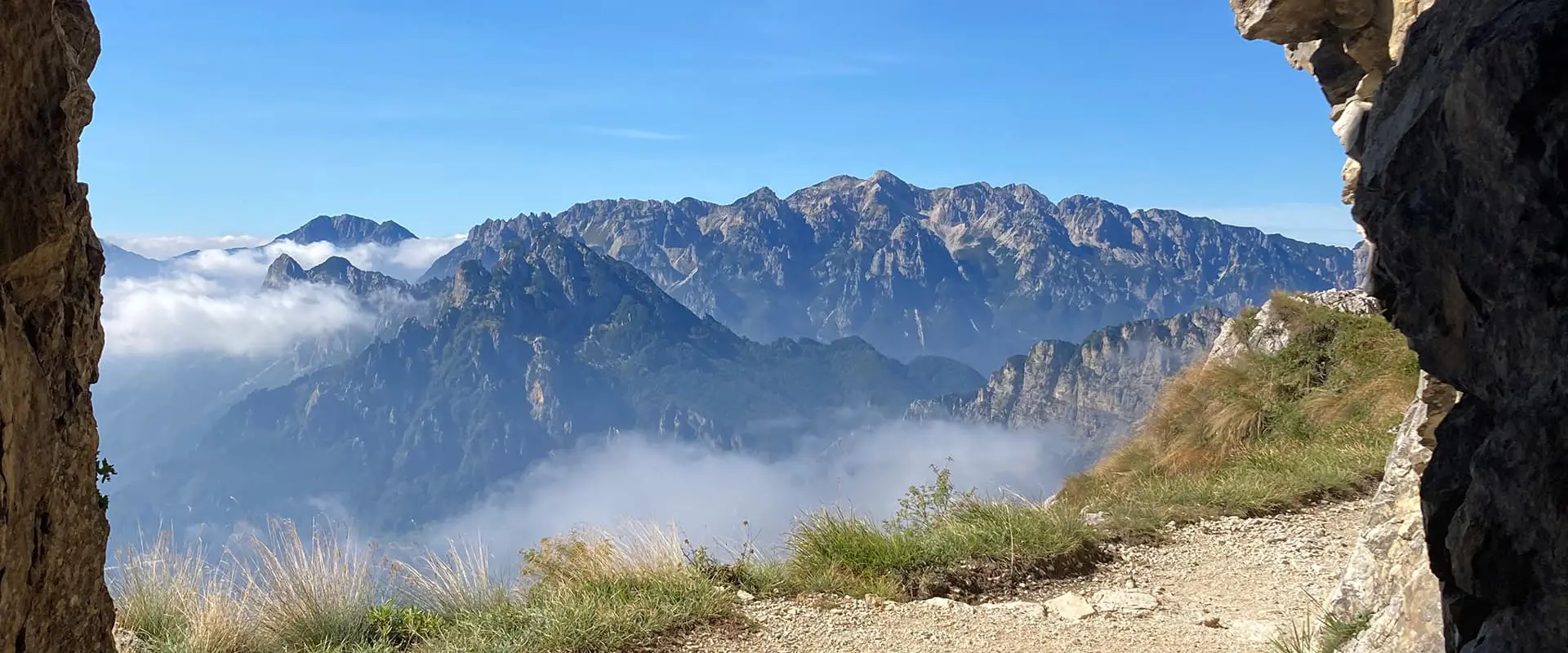
Today, it can be hiked as a circular day hike from Bocchetta Campiglia (1216 m) to the mountain hut Rifugio Achille Papa (1928 m) and back down via the “Strada deli Scarubbi” on the north side of the mountain. Besides being a path to remember the war and soldiers, it is spectacularly beautiful and has views of the Piccoli Dolomiti if the weather conditions are fine.

person posing for a picture in the mountains

Astrid Meering

Astrid Meering alternates living between the Netherlands and Italy. She started hiking in 2008 with the aim of hiking Hadrian’s Wall in the U.K. and got infected with the hiking virus from that trail on. As an archaeologist, she loves to hike trails with a historical background. From ancient Etruscan roads to medieval pilgrimage trails; there’s a story to be found everywhere.

View profile

The Trail

The Strada delle 52 Gallerie starts near the parking lots in Bocchetta Campiglia above the Xomo pass. The modern entrance of the walk is rather striking, with a pavilion flanked by iron silhouettes of soldiers. Here, you can read a bit about the history of the Strada on information panels before walking to the official entryway, an arch commemorating the building in 1917.

Soon you will enter the first of the 52 tunnels. For the first half, the path climbs steeply up, then flattens out into a more gentle slope along the mountainside. The tunnels are all numbered, and there are occasional information panels explaining military use or showing ancient pictures of the ongoing works. Tunnel 19 is the longest (320 m), and number 20 spirals several times up through the rock. Also, there are several plaquettes along the path commemorating modern-day hikers who fell from the path to their death.

At the end of the path, after 3 to 3.5 hours hiking, the mountain hut of Achille Papa will be a welcoming place for a rest. It has a bar and terrace with views, a restaurant (open from 11:30-15:30 and 19:30-21:30), and provides simple accommodation as well.

From the mountain hut, you cross the ridge to a broad, unpaved road called Strada deli Scarubbi that is suitable for cars. It goes all the way down on the other side of the mountain. Just follow the road (where there are a lot of curves, it is often possible to use a quicker path that cuts them off), it will bring you back to the parking lot in 2 to 2.5 hours.

Accommodations

Rifugio Achille Papa has beds in a dormitory during the opening months. You can email them (rifugiopapa@caischio.it) or call them (+39 0445 630233) to reserve your space.

The closest possible place to stay close to the beginning of the trail is the mountain hut Rifugio Passo Como. It offers private rooms, a bar, and a restaurant. It is closed during the winter months. If you prefer to stay in a small village, Ristorante Albergo Al Garibaldino in Posina is a good option.

Best time of the year

The trail is open for hikers from spring to autumn, when the mountain hut at the top is open. To avoid occasionally late or early snowfall, mid-June to the beginning of October generally provides the best weather and views. The summer months, July and August, attract more hikers. Due to weather conditions, the trail and mountain huts are closed in winter (November to June).

Safety & Gear

The trail is easy to follow as it has a clear beginning and end. There are no signposts other than the numbered tunnels and some information panels up to the mountain hut Achillo Papa.

The first part of the trail is not a leisurely walk. Be prepared; check the weather forecasts beforehand, wear good hiking boots because the tunnels are often wet and proper clothing in layers. A headlamp or torch is necessary for crossing tunnels. Poles might be useful. In summer, a sun hat, sunglasses, and sun protection are recommended.

Due to weather conditions and snow, avoid hiking in the winter season when the mountain huts are closed.

Difficulty

The Strada delle 52 Gallerie is a difficult hike. The first half of the path up to the mountain hut Achilla Papa is the most difficult part. It consists of a stony mule path, at places narrow and exposed. Therefore, the hike is not recommended for people who suffer from vertigo. To hike through the often wet and curved tunnels, you’ll need a torch or headlamp.

The Strada degli Scarubbi road from the Rifugio back to the parking lot is a broad, unpaved road, accessible by cars and easy to hike.

Good to know

Bring some coins as the ticket machines at the parking lot do not accept paper money or cards.

There are several other hikes starting from the Rifugio Achille Papa, in case you like to extend the hike, or you stay overnight.

The Strada delle 52 Gallerie is part of a much larger defence system. If you are interested in its history, you should consider visiting the small museum and Ossuary monument in Pian Delle Fugazze (open mid-May through the end of September, Tuesday-Sunday, 9-12:30 and 14-18).

route
point-to-point
highest point
1928m (6325 ft)

Want to submit a trail or make this page more complete?

Always read the disclaimer

Terms of Use: important to all visitors on this website. We strive to publish high quality content and information on this website. However it’s always possible that we’re missing out on some crucial information. In spite of the fact that this route, associated GPS track (GPX and maps) were prepared under diligent research by the specified contributor and/or contributors, the accuracy of such and judgement of the author is not guaranteed. Therefore, hiking-trails.com and contributors are in no way liable for personal injury, damage to personal property, or any other such situation that might happen to individuals hiking or following this route. Should you choose to hike this trail, this is always at your own risk. Check out our guidelines for safety hiking and Leave No Trace principles at the hiking 101 page.

Download GPX

Join the community!

Login or create a FREE account 😊

With an account you can:

Download GPX files

Pin trails to your wishlist

Mark trails as hiked by you

Rate hiking trails

Comment on trails, blogs and gear reviews

Happy trails!
Login

Don't have an account yet? Register here