Logo Aletsch Arena

About the Stoneman Glaciara Hike

Aletsch Arena
country
Switzerland
length
60 km(37 mi)
Type of trail
Long-distance
difficulty

Difficulty is highly personal. Be aware of the weather conditions as bad weather turns easier trails in difficult trails especially in the mountains.

Difficult
accommodation

Lodging means a mix of hotels, hostels or AirBnB’s.

Lodging, Mountain huts
Elevation gain
3341 m(10961 ft)
terrain
Mountains
remoteness
Some of the time
Show more

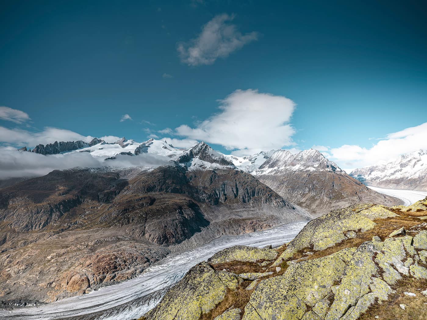
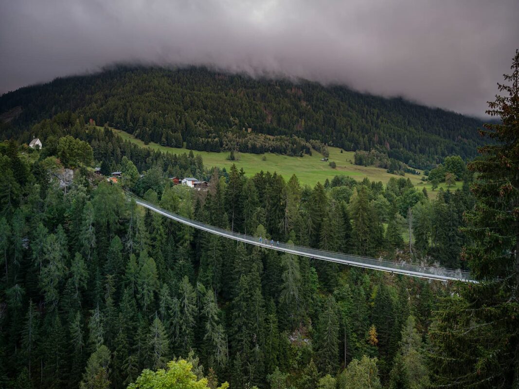
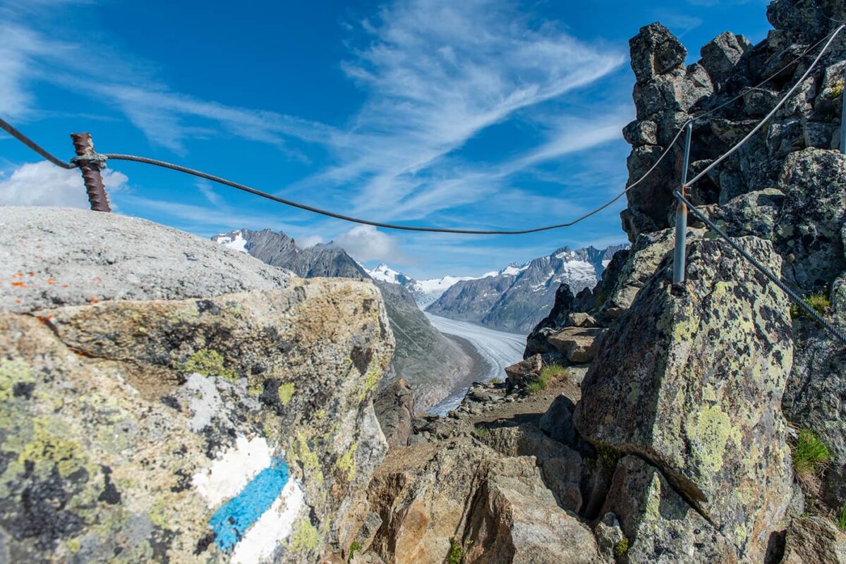
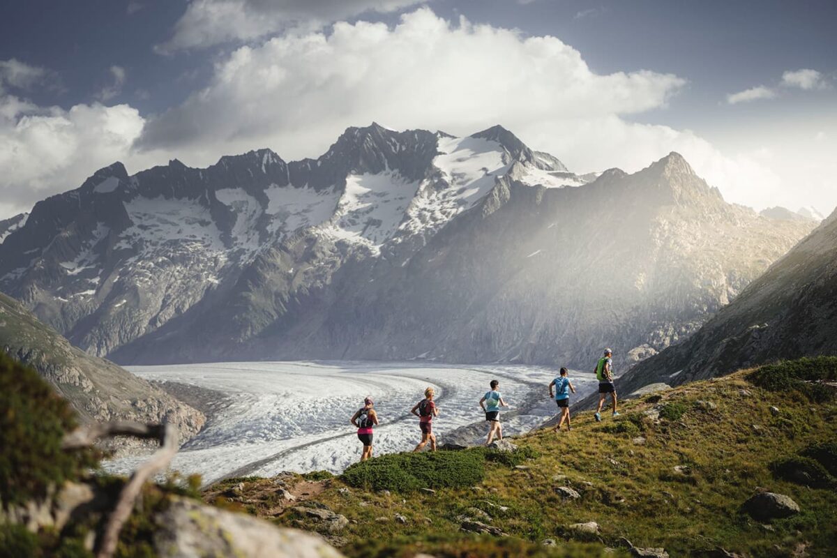
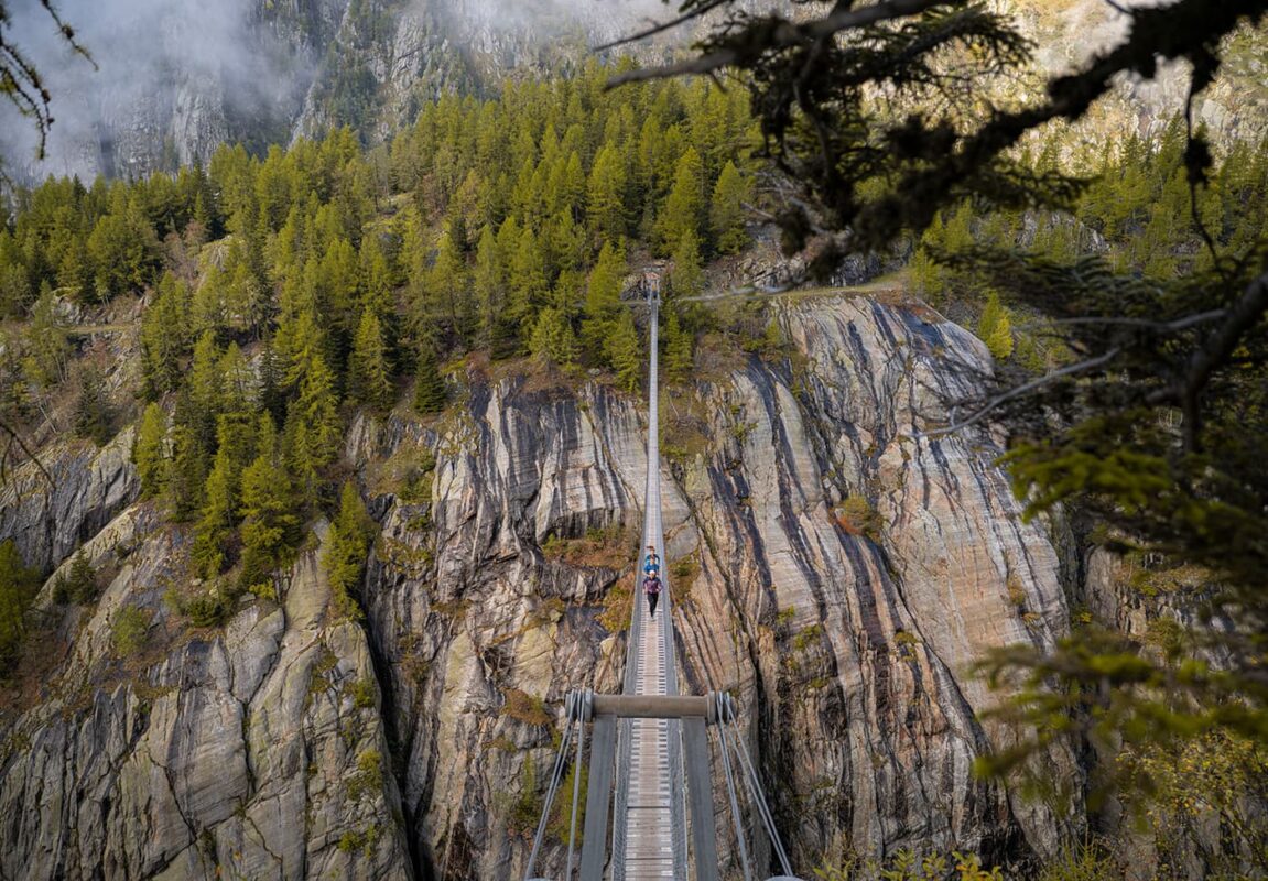
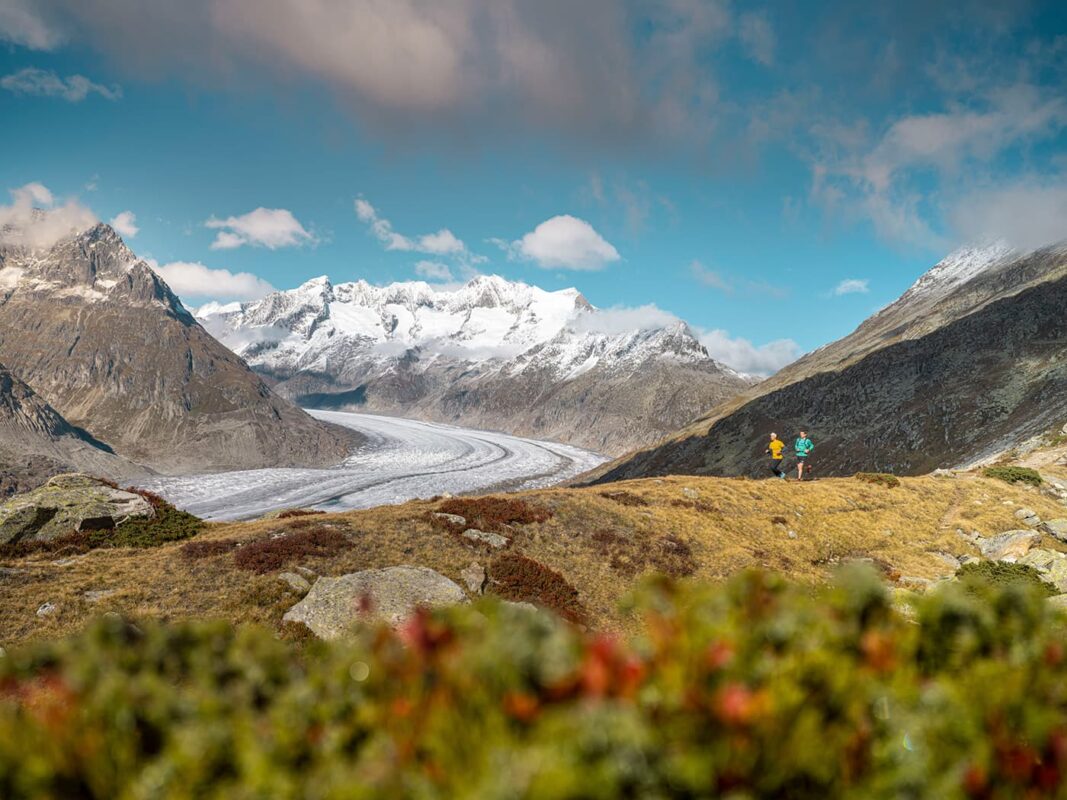
Discover the brand new Stoneman Glaciara Hike in the beautiful Aletsch Arena. On this trail, you will trek alongside the Aletsch Glacier, the largest glacier in the Alps. This unique long-distance trail offers an elevation gain of 3150 meters, traverses two suspension bridges that span across the valley, and has a ridge walk as you’ll follow for more than 12 kilometers among the Aletsch glacier.

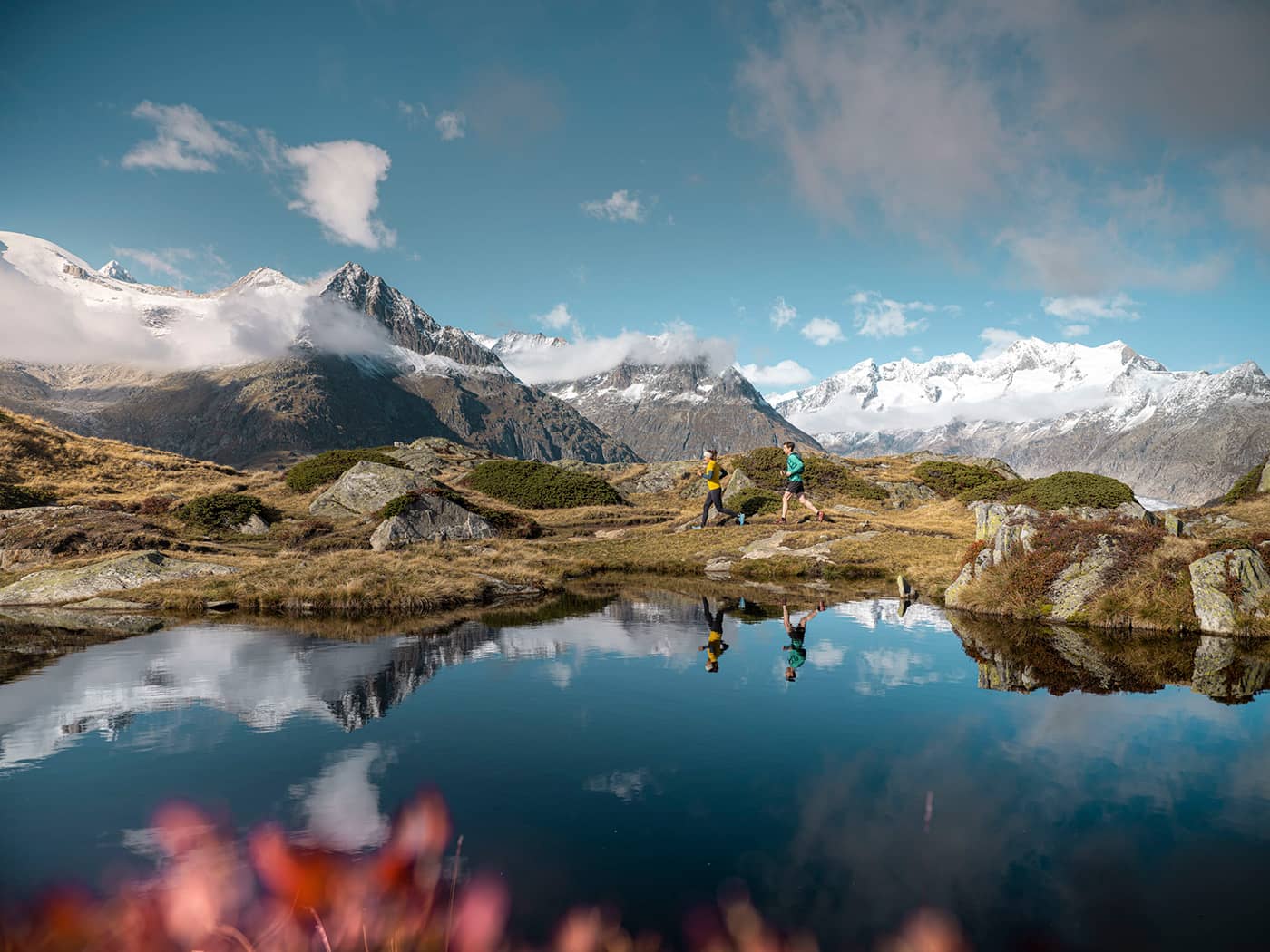
The Aletsch Arena, part of the Swiss Alps Jungfrau-Aletsch UNESCO World Heritage Site, offers 300 kilometers of hiking trails ranging from high-altitude technical trails to hiking trails for families, spanning the whole region. These trails provide an opportunity to explore the diverse natural landscapes of the area, from the unique and longest glacier in the Alps to ancient stone pine forests, some of which are over 1000 years old. The region is known for its five suspension bridges in the Aletsch Goms area, offering one-of-a-kind days on the trails.

Editor

Elmar Teegelbeckers

Passionate hiker Elmar spends months of his time on the trail. He’s usually on the lookout for hidden gems in one of his favourite countries such as Slovenia, Switzerland and Japan. He founded hiking-trails.com in need for a community and detailed information about the trails. Before this, he worked for the Alpine asscociation in the Netherlands[ (NKBV) but lost his heart to the trails.

With this website and socials, he hopes to shape an inclusive community for hikers all over world. No matter your speed, experience or level, you can get out there to enjoy the trails and connect with the heartwarming hiking community. Life is so much better outside and he hopes to inspire hikers to take their first, or next, step on the trail.

View profile

The Trail

Starting from Biel in the Goms area, the trail heads up to the Goms Höhenweg, a high-altitude trail. From there, it continues towards Bellwald, leading you to the Aspi-Titter suspension bridge. After crossing the bridge, the trail involves a steep climb towards Märjelenwang. When reaching the Märjelen valley, you will go past Lake Märjelensee and ascend to Eggishorn, which has views of the pristine Aletsch Glacier. If you’re looking for a less demanding option, the Panorama Trail is available as an alternative.

The trail takes you over the high-altitude trail towards Bettmerhorn and then to the Moosfluh viewpoint. From here, you will descend to Bettmeralp, followed by a hike towards Alpmatten and Martisberg, eventually reaching the Sport Resort in Fiesch. The trail crosses the Rhone, with stops at Ernen and Mühlebach, and returns across the river via the second suspension bridge: Goms Bridge.

The final leg includes an uphill hike to St. Anna Chapel, which will set your direction toward Niederwald. On your way, you will cross the Rhone again before Blitzingen, and then follow the Gommer Waldweg, a forest trail, to Reckingen. The trail ends with a hike back to the starting point in Biel where you’ll finish this 65-kilometer circular trail.

Stages

You can hike the Stoneman Glaciara hike at your own pace, choosing distances that suit you. You can also choose your starting point, for example, Biel is a great option. A version of the route is to hike the trail in these three stages.

Stage 1:

Biel – Gletscherstube, 15 km | 9 mi

Stage 2:

Gletscherstube – Fiesch, 22 km | 14 mi

Stage 3:

Fiesch – Biel, 23 km | 14 mi

Accommodations

You can choose a variety of accommodations in the villages along the way. These are the suggested accommodation options at the end of this three-day itinerary.

Overnights per stage

Stage 2:

Fiesch

Stage 3:

Biel

Best time of the year

The best time to hike the Stoneman Glaciara Hike and overall in the Aletsch Arena is from June through late September. This period is the best hiking season in the Aletsch Arena because the weather is the most stable with longer daylight hours. During this time, the high-altitude meadows bloom with a vibrant array of alpine flowers, and the trails are mostly snow-free. In June there might be some snow on the trails but in July it should be melted, making it easier to hike the trails, especially the more challenging routes.

Autumn brings a beautiful hiking experience with lesser crowds and the landscape turns into a stunning palette of golds, reds, and browns. However, the weather can be more unpredictable with a higher chance of snowfall. Mornings can be crisp, and higher altitudes might start to see the first dustings of snow within this period.

Safety & Gear

Before setting out, check the weather forecast and be aware of the trail conditions such as snow. Ensure your fitness is enough for hiking this trail. Bring a map and put the GPX on your mobile for navigation. Make sure to have a fully charged phone, possibly with a power bank.

Dress in layers and always bring a hardshell and warmer (down) jacket with you to adapt to changing conditions, Choose hiking shoes with a good grip. Other essentials include a first-aid kit, extra food, and water.

Mountain weather can change rapidly. Be prepared for sudden drops in temperature and unexpected rainfall. Start your day early to avoid being caught by afternoon thunderstorms that are common in mountainous regions. Stay on marked trails to minimize environmental impact and reduce the risk of getting lost. Yield to uphill hikers and be mindful of wildlife. Leave no trace by packing out all the trash.

Good to know

Hiking in the Aletsch Arena is a unique experience. It’s important to know that the Stoneman Glacier Hike is no walk in the park. The trails go over varied terrain including high-altitude alpine trails, rocky paths, and alpine meadows only advised for experienced hikers who don’t have a fear of heights. Weather in the Alps can change rapidly. Before setting out, check the local weather forecast and be prepared for all conditions. Morning hikes are often recommended to avoid afternoon thunderstorms.

Route
Circuit
Highest point
2840 (9317 ft)

Guidebooks

Logo Aletsch Arena

Aletsch Arena Downloads

View guidebook

Want to submit a trail or make this page more complete?

Comments

Be the first one to comment on this trail!

Reply to this trail

Your email address will not be published. Required fields are marked *

Reply to this trail

Log in to comment on this trail
Always read the disclaimer

Terms of Use: important to all visitors on this website. We strive to publish high quality content and information on this website. However it’s always possible that we’re missing out on some crucial information. In spite of the fact that this route, associated GPS track (GPX and maps) were prepared under diligent research by the specified contributor and/or contributors, the accuracy of such and judgement of the author is not guaranteed. Therefore, hiking-trails.com and contributors are in no way liable for personal injury, damage to personal property, or any other such situation that might happen to individuals hiking or following this route. Should you choose to hike this trail, this is always at your own risk. Check out our guidelines for safety hiking and Leave No Trace principles at the hiking 101 page.

Download GPX

Join the community!

Login or create a FREE account 😊

With an account you can:

Download GPX files

Pin trails to your wishlist

Mark trails as hiked by you

Rate hiking trails

Comment on trails, blogs and gear reviews

Happy trails!
Login

Don't have an account yet? Register here