About the Skye Trail

country
Scotland
length
120 km(75 mi)
Type of trail
Long-distance
difficulty

Difficulty is highly personal. Be aware of the weather conditions as bad weather turns easier trails in difficult trails especially in the mountains.

Difficult
accommodation

Lodging means a mix of hotels, hostels or AirBnB’s.

Wild camping, Lodging
Elevation gain
3000 m(9843 ft)
terrain
Hills, Coastal
remoteness
Some of the time
Show more

The Skye Trail is a challenging, unofficial long-distance route traversing the Isle of Skye in Scotland, covering approximately 120 kilometers. It stretches from Rubha Hunish in the north to Broadford in the south, offering hikers a unique opportunity to experience the varied landscapes of Skye. The trail encompasses rugged terrain, including sharp mountain ridges, serene lochs, and dramatic coastlines. Despite its beauty, the Skye Trail is not waymarked, requiring navigational skills and self-sufficiency from walkers. It passes through iconic landmarks such as The Quiraing, The Storr, and the Cuillin Ridge. The trail is best tackled by experienced hikers, prepared for the unpredictable Scottish weather and the remote, wild nature of the terrain.

Profile picture Sancia Gimbel.
Author

Sancia Gimbel

Sancia Gimbel, born and raised in Germany, has always searched for her next adventure. Having predominantly traveled solo, she is well acquainted with the advantages and disadvantages of being a solo hiking woman. Having hiked several trails all over Europe, her favorite place (and biggest adventure) is still Scotland.

Her current plan is to explore South America, mostly through backpacking and hiking in Patagonia, and North America through road trips and hiking over the next few years. You can follow her adventures on Instagram!

View profile

The Trail

Let’s say it right out: this is not a beginner’s route! The Skye Trail is an unofficial path, lacking waymarks, and often without defined paths at all. It is situated on the half island “Isle of Skye,” the largest and northernmost island right off the northwest coast of Scotland. The name, derived from “Isle of Clouds,” also referred to as the “Isle of Fog,” gives you a little impression of what’s coming up.

This trail guides you along remote paths over the hills of Trotternish Ridge, the black & red Cuillin, through the wild Highlands and Coast Cliffs. Not without reason, this area is known as the most dramatic and beautiful mountain area in the whole of the UK.

You will also encounter very unique flora along your way. Don’t forget to keep an eye out for whales, dolphins, seals, and the famous sea eagle. I would say this is an all-in-one package of everything you could wish for in one trip.

As there are no waymarks and sometimes no paths at all, so excellent map-reading skills are needed! You can find offline maps on different apps and websites, but believe me, navigating through the boggy Highlands without a visible path is much easier with a paper map and a good overview. However, having offline maps on your phone as a safety backup? Absolutely!

Good gear that withstands the Scottish weather and wind is also a must-have! Known as the Isle of Fog, you can imagine that bad and stormy weather is often not far away. Please be aware of these conditions. Some parts require climbing, and these areas become extremely slippery when wet. Exposed sections are dangerous with poor visibility. Always check the weather daily!

But why is this tour still considered “moderate to difficult”? If you choose to hike this trail during summer and are lucky enough to have good weather for seven days in a row, this trail is moderate to manage. However, if you’re not that fortunate or choose to hike it off-season, some sections can become dangerous!

So, are you ready for a journey steeped in myth, legend, and natural beauty?

Stages

Most hikers choose to hike the Skye trail in 7 days on the 7 official stages of the trail. Hike from Rubha Hunish till Broadford on this magical long-distance trail.

Skye trail 7 stages itinerary

Stage 1:

Rubha Hunish – Flodigarry, 11.5 km | 7 mi

Stage 2:

Flodigarry – The Storr, 28 km | 17 mi

Stage 3:

The Storr – Portree, 14 km | 8.5 mi

Stage 4:

Portree – Sligachan, 19 km | 12 mi

Stage 5:

Sligachan – Elgol, 18 km | 11 mi

Stage 6:

Elgol – Torrin, 16.5 km | 10 mi

Stage 7:

Torrin – Broadford, 20 km | 12.5 mi

Accommodations

You won’t find many facilities along your way, so plan to pack food for about 3-4 days. Your bus journey will take you to Portree, where you can find a few shops to get your supplies for the first few days. Approximately halfway through your journey, you’ll re-enter Portree for a refill. Water, on the other hand, is not a problem as you’ll encounter plenty of water sources along your route, but please use a water filter.

Accommodations are not always guaranteed, so a tent is a must-have for this tour. Trotternish, Fodigarry, and Sligachan offer B&Bs and hotels. Portree, Elgol, and Broadford have B&Bs, hotels, and shops. However, keep in mind that spending a night in accommodation can be very expensive on Skye. You’ll find some campsites along your way for a more economical stay. The best part is that you’ll encounter two famous bothies on your journey: Rubha Hurnish and Camasunary.

For those who wanna walk on the safe side, there are plenty of guided tours.

Best time of the year

Similar to many other countries, the optimal time for hiking is during the summer months (April-September). However, Scotland offers a unique proposition with its landscape dominated by hills, lots of hills! The highest mountain, Ben Nevis, stands at 1345m (4413ft). So yes, Scotland is hikable all year long, and each season brings its advantages and challenges.

Summer Months: During the summer, you are blessed with long days, providing ample time to cover your distance without feeling rushed. It’s an opportunity to enjoy lochs for a swim and have leisurely lunches with scenic views. Especially in certain highland areas, hiking during the dark should be avoided due to boggy terrains that require special attention. The summer months generally offer the driest days, with temperatures reaching about 18-20°C (65-68°F). However, Scotland’s abundance of water, including rivers, lakes, and marshes, brings its biggest challenge: MIDGES! Tiny little mosquitoes that can be quite bothersome and sting.

Winter Months: On the upside, winter months are free of midges, but there’s a trade-off. Expect a lot of rain, and snow is possible from the end of October until March. The days become significantly shorter, nights colder, and storms more frequent, making camping more challenging. But in the winter months, you have the opportunity to see the country with fresh eyes as trees and fields undergo a transformation, changing their colors from green to warm orange all over.

In conclusion, a very German piece of advice from my side: “There’s no such thing as bad weather, only the wrong gear!” Scotland will be your grandest adventure with the right equipment.

Safety & Gear

For Summer Months

  • Don’t forget a mosquito net for your face, thin long sleeves, trousers (no worries, Scottish summers rarely exceed 20°C), or insect repellent.
  • Opt for a tent that is mosquito-safe.
  • Since it rains about 182 days in Scotland (265 days in this part), a rain jacket is essential, even in summer. You will never be safe from getting wet.

For Winter Months

  • Always pack a hardshell raincoat and rain trousers – you will get wet!
  • Depending on your chosen trail, include an ice axe and crampons.
  • A tent is often inevitable, especially in remote areas where bothies or village accommodations may not be accessible. During winter, storms can be intense, so ensure your tent has sufficient safety lines. If not, your tent may break or fly away. A dangerous situation in which none of us wants to find Ourselves.

General Gear

  • A water filter is a must-have due to Scotland’s abundance of water sources and rich wildlife. Filter or boil water for at least 3 minutes. This way some areas even allow you to carry none at all.
  • A paper map is essential not just for simplynavigatinge this trail but also for a good overview of the area, helping you find quick escape routes or alternative paths.
  • Scotland is home to diverse wildlife, including deer, birds, and seals. Not a danger to you but maintain a respectful distance to avoid disturbance.
  • Always check the weather before heading back on the trail.
  • Due to remote areas with unreliable reception, especially for solo hikers, a satellite tracker is highly recommended and can be a lifesaver.
  • A guidebook provides insights into upcoming terrain and helps you find suitable spots for your tent, considering the boggy areas where camping may be restricted.

With this comprehensive gear, you can hike with confidence, whether navigating through summer rains or winter storms. Stay safe and enjoy the adventure!

Good to know

How to Get Around

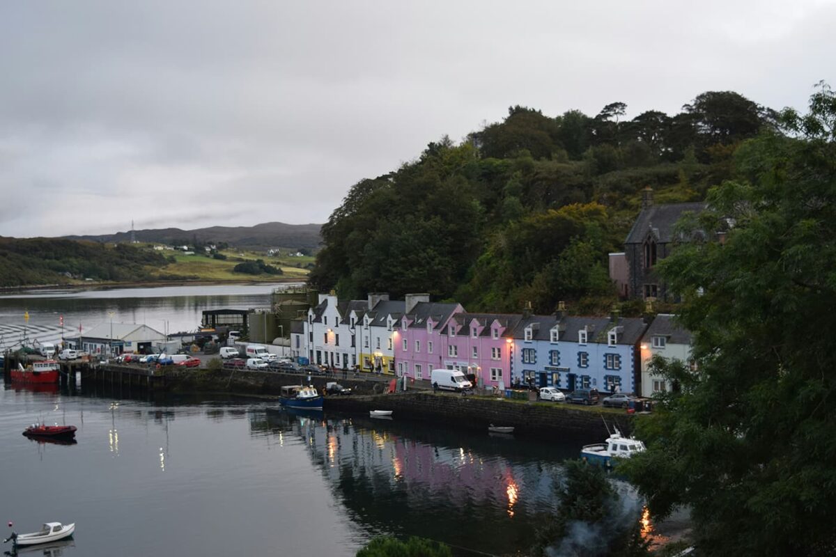
Take a flight to Glasgow, Edinburgh, or Inverness, where you can catch a bus to the Isle of Skye, specifically to Portree, the capital of the island. Most people choose to stay in Portree for the first night. There’s also a free campsite, “Skye Live Campsite” (without any facilities), where you can spend the night.

In the morning, take a bus to start your journey. You’ll begin at Rubha Hunish, where there’s also a bothy for the first night. To reach Rubha Hunish, take Bus 57A and inform the driver that you’ll be hiking the Skye Trail. The driver will drop you off at the red old telephone box, marking the starting point of your tour.

Your endpoint is Broadford, a small town with all the facilities you need, including a bus stop for your return journey to the mainland.

Wild camping

Wild camping is officially allowed in Scotland! Let me tell you about the “Scottish Outdoor Access Code” (link below).

Lightweight camping is permitted in small numbers and only for 2 or 3 nights at the same place. Do not camp on private property, in enclosed fields of crops, or near farm animals, and stay well away from buildings, roads, and historical structures. Do not disturb deer stalking or grouse shooting. If you’re close to a house, ask the landowner for permission (Scottish people are super friendly 😊). Of course, stick to the Leave No Trace principles.

There are some special rules for specific National Parks; please check them out on their website. Additionally, they have a useful page about campsites all over the country and a lot of other helpful information!

Scottish bothies

Hiking in Scotland offers a special treat: their bothies! While we’re all familiar with mountain shelters, often used in emergencies or bad weather, they may not always entice us to spend a night unless absolutely necessary. However, the Scottish bothy takes the experience to a whole new level. Some even come equipped with a flushing toilet or electricity. These huts are lovingly cared for, not just by the Mountain Bothy Association (yes, you can become a member and support them), but also by locals who enjoy spending a night in the wilderness.

The best part? You don’t pay, but it operates on a system of trust and respect:

  • Always leave the bothy better than you found it!
  • Everyone is welcome! It’s not “your” bothy.
  • You can leave useful things for the next people but never leave rotting food.
  • Bury human waste far away from the bothy and water sources.
  • Ensure the doors and windows are properly closed when you leave.

Keep in mind, the act of offering us a free and often charity-run shelter is a kind one! Please treat it with the utmost respect!

Route
Point to point
Highest point
651m (2135 ft)

Guidebooks

cover guidebook

The Skye Trail

View guidebook

Want to submit a trail or make this page more complete?

Comments

Be the first one to comment on this trail!

Reply to this trail

Your email address will not be published. Required fields are marked *

Reply to this trail

Log in to comment on this trail
Always read the disclaimer

Terms of Use: important to all visitors on this website. We strive to publish high quality content and information on this website. However it’s always possible that we’re missing out on some crucial information. In spite of the fact that this route, associated GPS track (GPX and maps) were prepared under diligent research by the specified contributor and/or contributors, the accuracy of such and judgement of the author is not guaranteed. Therefore, hiking-trails.com and contributors are in no way liable for personal injury, damage to personal property, or any other such situation that might happen to individuals hiking or following this route. Should you choose to hike this trail, this is always at your own risk. Check out our guidelines for safety hiking and Leave No Trace principles at the hiking 101 page.

Download GPX

Join the community!

Login or create a FREE account 😊

With an account you can:

Download GPX files

Pin trails to your wishlist

Mark trails as hiked by you

Rate hiking trails

Comment on trails, blogs and gear reviews

Happy trails!
Login

Don't have an account yet? Register here