About the Routeburn Track

country
New Zealand
length
33 km(21 mi)
Type of trail
Long-distance
difficulty

Difficulty is highly personal. Be aware of the weather conditions as bad weather turns easier trails in difficult trails especially in the mountains.

Moderate
accommodation

Lodging means a mix of hotels, hostels or AirBnB’s.

Camping, Mountain huts
Elevation gain
1487 m(4879 ft)
terrain
Mountains, Forest
remoteness
Some of the time
Show more

The Routeburn Track is one of New Zealand’s prime hiking trails, showcasing fantastic landscapes, a huge variety of wildlife, and a chance to see the beautiful alpine parrot, the Kea! Deep in the heart of Fiordland National Park and Mount Aspiring National Park, this 33-kilometer point-to-point trail is a must-do for any outdoor enthusiast who finds themselves in New Zealand. You can hike the trail in the summer or the winter, if you can manage to get permits.

This trail is a beautiful way to see two of the National Parks that New Zealand is so well-known for. You will hike for roughly three days and get to experience the “kiwi” mountain huts, see wildlife that is unique to the islands, and have solitude from the craziness of the cities.

women with blond hair and hat on
Author

Linde van Emmerik

Originally, Linde grew up in The Netherlands, but after graduating she made the move Down Under and spent six years between Australia and New Zealand. This is where she truly found her love for nature. She’s a little silly, which resulted in embarking on a journey of a lifetime: Te Araroa. Without ever having done an overnight hike, she decided to hike the length of New Zealand and got swept off her feet by the beauty this country had to offer. In 2024 she moved back to her home country, a country without a single mountain. So instead of climbing summits and hiking in the backcountry, she does the next best thing: write about it!

You can follow Linde on Instagram @lindevanemmerik

View profile

The Trail

The Routeburn Track is one of New Zealand’s prime hiking trails, showcasing fantastic landscapes, a huge variety of wildlife, and a chance to see the beautiful alpine parrot, the Kea! Deep in the heart of Fiordland National Park and Mount Aspiring National Park, this 33-kilometer point-to-point trail is a must-do for any outdoor enthusiast who finds themselves in New Zealand. You can hike the trail in the summer or the winter, if you can manage to get permits.

This trail is a beautiful way to see two of the National Parks that New Zealand is so well-known for. You will hike for roughly three days and get to experience the “kiwi” mountain huts, see wildlife that is unique to the islands, and have solitude from the craziness of the cities.

The Routeburn Track begins at the Routeburn Shelter on the eastern side, near Glenorchy. For those planning to do this hike, transport logistics can be tricky since the trail is not a loop. Many people arrange shuttles, hitchhike, or even swap car keys with other hikers at the halfway point to minimize costs. Another option is to hike it as a “there-and-back,” by turning around at the finishing point and returning the same way you came. However, if you’re traveling on a one-time trip to New Zealand, I highly recommend you arrange transport!

Once you leave the car park, the trail starts with a gradual climb through a beech forest, following the super clear Routeburn River. The path is well-maintained and easy to navigate, making it an enjoyable start to the hike. Along the way, you’ll come across small waterfalls, lots of moss-covered trees, and occasional clearings where you can see the surrounding mountains. About 7 kilometers in, you’ll reach the turn-off to Routeburn Flats Hut. Once you get to the hut, the Humboldt Mountain Range reveals itself, a glimmer of the stunning views to come! This is a fantastic spot to take a break or enjoy lunch. The hut sits in a beautiful valley with views of the surrounding peaks and river flats. The peaceful atmosphere here makes it the perfect place to grab yourself a snack and recharge before tackling the next (steeper!) section.

From Routeburn Flats Hut, the trail begins to ascend quite steeply. As you climb, the forest slowly starts to thin, and more and more views open up, giving you the stunning panoramas that probably convinced you to go on this hike in the first place. The steep climb lasts for just over 2 kilometers until you arrive at Routeburn Falls Hut. It simply gives some of the most amazing views with the snow-capped mountain peaks in winter!

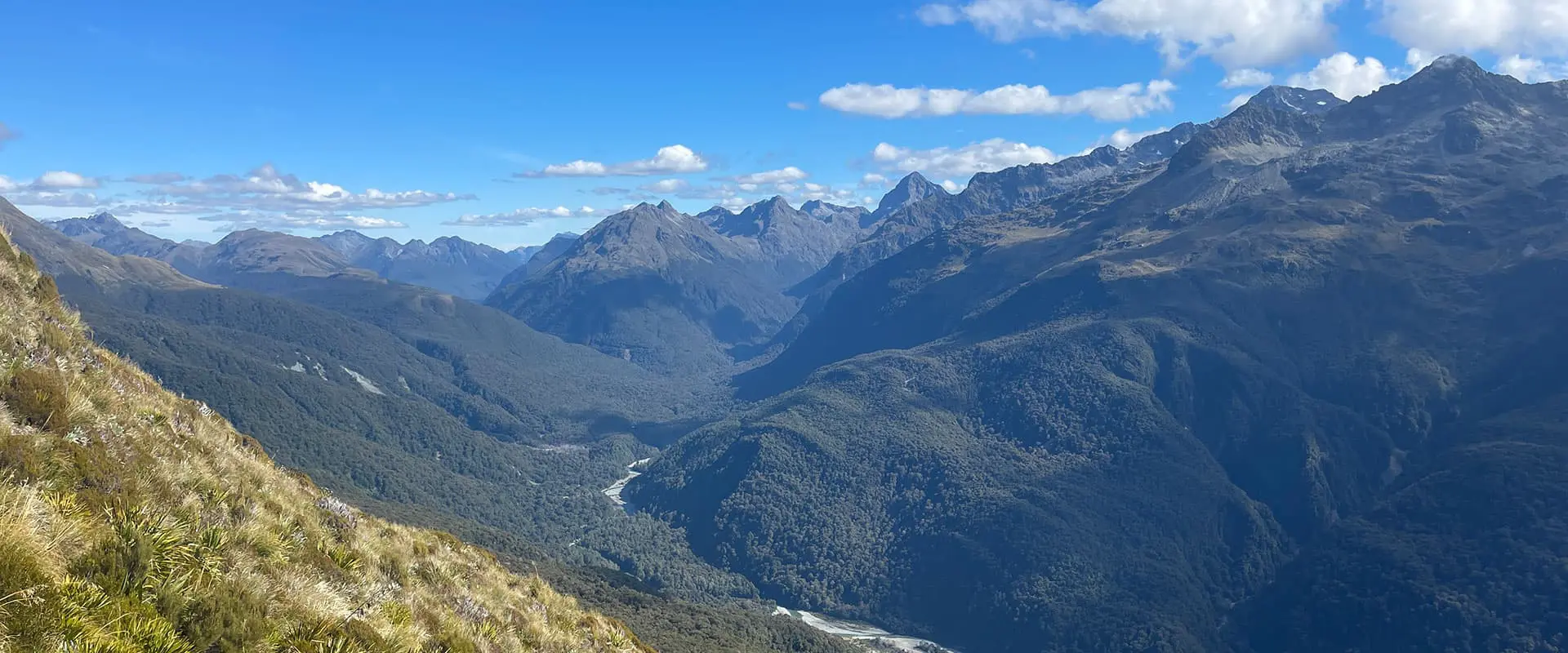
The next morning, the track continues its climb toward Harris Saddle, which is the highest point on the Routeburn Track at 1255 meters. The climb is more challenging here, with rockier terrain and some light scrambling required. In winter, the trail can be icy or snow-covered, so caution and appropriate gear are essential. However, your effort will be well worth it! The views from Harris Saddle are simply spectacular, where you will have a panoramic perspective of Fiordland’s beauty. The saddle also has an emergency shelter, which can be useful in case of bad weather. Warm up, make yourself a cup of coffee, or simply stop for snacks or lunch. Having lunch outside is highly recommended if the weather allows. You’d want to soak up these views as much as possible!

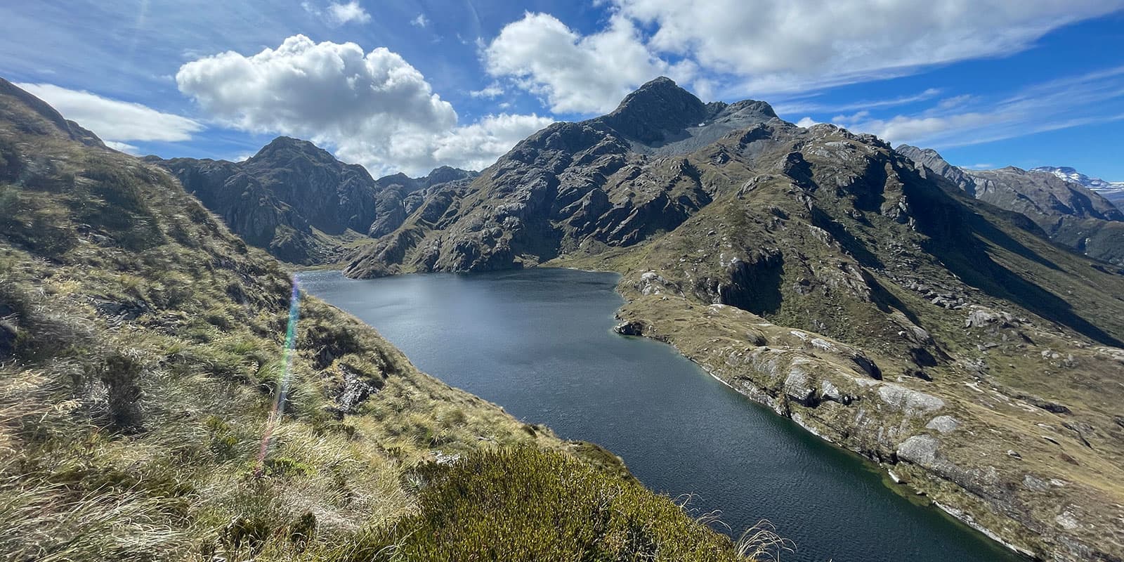
From Harris Saddle, there’s an optional side trip to the Valley of the Trolls. This detour is a hidden gem that’s well worth the effort if you have the time and energy. The trail leads you down into a valley surrounded by peaks where there is an alpine lake. Camping here adds an extra day to your trip and provides an unforgettable wilderness experience. Bear in mind, although the foot traffic has made the route quite obvious, it is an unmarked trail, and there are no facilities or huts this way, so make sure you download the GPX and carry your own camping gear if you decide to go down this route. It also means walking back the same way to get back onto the Routeburn Track.

If you skip the Valley of the Trolls, then after Harris Saddle the trail begins to descend toward Lake Mackenzie. The landscape transitions from open alpine terrain back to forested areas, but not before you get to take a good look at the beautiful lake in front of you. With the path winding past waterfalls and a few rocky bits, the descent is steady and well-graded, although some sections can be slippery in wet or icy conditions.

Lake Mackenzie Hut, located on the shores of the emerald-green lake, is a highlight of the track. The hut’s layout and facilities are excellent, which make it a comfortable and scenic place to spend the night. A perfect place to rejuvenate after you’ve crossed Harris Saddle! I’ve camped here before, and waking up to the tranquil lake surrounded by misty mountains is an experience that’s hard to beat. However! Make sure you bring plenty of insect repellent, as the sandflies love any bare skin that you give them.

The final stretch of the Routeburn Track leads from Lake Mackenzie to The Divide, the western trailhead. This section of the trail is about 12 kilometers long and passes through a variety of landscapes, including mossy forests, alpine meadows, and even a section of boardwalks through a boggy area. Highlights include the Earland Falls, a 174-meter cascade that’s particularly impressive after heavy rain. As you approach The Divide, the trail gradually descends, where you will have views of the Hollyford Valley and Darran Mountains. The final section is pretty easy, so you can soak in the last of the incredible scenery before reaching the end of the trail. If arranged, the car park here is where you’ll be picked up!

Stages

When hiking the Routeburn Track east to west without a detour to the Valley of the Trolls, these are the recommended stages.

Suggested 3-day Routeburn Track Itinerary

Stage 1:

Routeburn Car Park – Routeburn Falls Hut, 9.8 km | 6 mi

Stage 2:

Routeburn Falls Hut – Lake Mackenzie Hut, 11.3 km | 7 mi

Stage 3:

Lake Mackenzie Hut – The Divide, 12 km | 7.5 mi

Accommodations

There are some strict rules on camping when you’re hiking the New Zealand Great Walks. This is due to the preservation of wildlife and native plants, and to maintain the best experience possible for all hikers. In theory, wild camping is allowed on this trail, as long as you’re 500 meters away from huts, as well as the trail. Needless to say, you must leave the place as you find it and you pack out all rubbish.

From experience, I can say: it wasn’t that easy to find a flat spot for my tent along this trail, which also follows the distance rule, but it wasn’t impossible! You’ll most likely have to rely on the options provided by the Department of Conservation, and in all honesty, the hut experiences in New Zealand are a highlight of the trail. Everything is well organized, and staying in a backcountry hut definitely adds to the NZ hiking experience.

Most people walk the Routeburn Track in 3 days, starting at the Routeburn car park, staying in Routeburn Falls Hut (48 bunks) and Lake Mackenzie Hut (50 bunks). But the beauty of this trail is that it can be walked in opposite directions, partially or as a single overnight trip. If you are starting from the Routeburn car park, after about 7 kilometers, there is a turn off to Routeburn Flats Hut (20 bunks), and a camping area. As I mentioned earlier, this can be a good spot for a break, but it’s also possible to spend the night here, if you’ve made a booking.

Otherwise, your first night will be spent at Routeburn Falls Hut, which is not only a great place to rest but also has a cozy and welcoming atmosphere. The hut is divided into separate sleeping quarters and a communal “living room” area, complete with large windows that frame the surrounding mountains. It’s a wonderful spot to spend the night, especially with the sound of the nearby waterfall providing a soothing backdrop. In winter, the area around the hut can be covered in snow, adding a bit more magic to the experience. On this particular trail, the options for accommodation are to stay in the following places:

There are a variety of organizations offering a guided walk of the Routeburn Track. In this case, your accommodation will most likely be included and will be in their private lodges, rather than the above-mentioned huts.

Best time of the year

The best time of the year to hike the Routeburn Track would be from late October until late April. This is within the New Zealand Great Walk Season and will be the summer season in the Southern Hemisphere. The area is known to get a lot of rain all year round; in the colder months and outside of the Great Walk Season, there’s the possibility of snow and ice.

The track remains open between May and October, but with limited facilities, and the weather, track, and avalanche conditions need to be carefully considered. Always contact the Fiordland National Park Visitor Centre before departure and take your own experience, safety, and abilities into consideration.

I personally have walked the Routeburn both in summer and part of the trail in winter too, and although it’s a lot colder and more preparation is required, the views are amazing with snow-capped mountain peaks. Bonus: you’ll avoid the summer crowds, and no hut bookings are required outside of the Great Walk season.

Safety & Gear

Planning any multi-day hike takes some preparation. For New Zealand in particular, the Department of Conservation has multiple visitor centers. Most of the time, they are located in a town close to the national parks. Not only do the visitor centers have a wide array of brochures to read about the trails in the area, but the staff also have accurate weather updates and will be able to answer all the questions you have. Don’t be afraid to stop by or give them a call! In addition to this, a lot of information can be found on the Department of Conservation website, which will be linked below.

Especially in the mountains of New Zealand, the weather can be unpredictable and change unexpectedly. Therefore, it’s important to be prepared for all weather conditions. Avoid hiking during severe weather like heavy rainfall, thunderstorms, or extreme heat. All these factors can be a risk to your safety. Other key factors for you to assess are trail difficulty, length, elevation gain, and terrain.

Carry navigational tools such as a compass or the downloaded GPX on your device to stay oriented and avoid getting lost. A PLB (personal locator beacon) can make a huge difference in case of an emergency. Make sure your maps or directions are accessible offline and don’t rely on just one app.

Invest in the right hiking gear, no matter if you’re going on a summer tramping trip or a winter adventure. Think about comfortable, supportive footwear, good hiking clothes, such as warm base layers and a hardshell rain jacket, hiking poles, a well-fitted backpack, and essential equipment like maps and a first-aid kit. Check out the comprehensive gear list for multi-day hikes like this.

Respect the principles of Leave No Trace by minimizing your impact on the environment. Stick to designated trails, pack out all rubbish, and respect the wildlife and their natural habitats.

Good to know

Every year the Department of Conservation will announce the date that bookings for the season open. If you don’t want to miss out, make sure you keep your eyes peeled! Once you’ve secured the hut passes, that’s great! Don’t forget to bring a copy of your booking confirmation and reference number, as the hut wardens might check them.

Missed out on tickets? No need to stress just yet! Throughout the year, plans change, and there’s always the chance of cancellations. Keep an eye on the booking system, as you might be in luck and snatch up some last-minute tickets. Reservations are not needed outside of the Great Walk season, but payment with hut tickets is still required. Staying in the hut will be determined on a first-come, first-served basis.

For New Zealand in general, I highly recommend the NZ Topo50 apps. There is a separate app for both North and South Islands, and it’s got all the information you need! Most marked trails are visible on the map, offline available when downloading the app, and you can import .gpx files as you like.

Route
point-to-point
highest point
1255m (4117 ft)

Want to submit a trail or make this page more complete?

Always read the disclaimer

Terms of Use: important to all visitors on this website. We strive to publish high quality content and information on this website. However it’s always possible that we’re missing out on some crucial information. In spite of the fact that this route, associated GPS track (GPX and maps) were prepared under diligent research by the specified contributor and/or contributors, the accuracy of such and judgement of the author is not guaranteed. Therefore, hiking-trails.com and contributors are in no way liable for personal injury, damage to personal property, or any other such situation that might happen to individuals hiking or following this route. Should you choose to hike this trail, this is always at your own risk. Check out our guidelines for safety hiking and Leave No Trace principles at the hiking 101 page.

Download GPX

Join the community!

Login or create a FREE account 😊

With an account you can:

Download GPX files

Pin trails to your wishlist

Mark trails as hiked by you

Rate hiking trails

Comment on trails, blogs and gear reviews

Happy trails!
Login

Don't have an account yet? Register here