About the Rothaarsteig

country
Germany
length
154 km(96 mi)
Type of trail
Long-distance
difficulty

Difficulty is highly personal. Be aware of the weather conditions as bad weather turns easier trails in difficult trails especially in the mountains.

Moderate
accommodation

Lodging means a mix of hotels, hostels or AirBnB’s.

Lodging, Camping
Elevation gain
3500 m(11483 ft)
terrain
Forest, Hills, Mountains
remoteness
Some of the time
Show more

The Rothaarsteig is one of Germany’s best long-distance hikes, and has even been given Germany’s Top Trails award! Only 13 trails hold this title, which shows how special it really is. You will hike through some of the most beautiful areas of Germany’s countryside, forests, low mountain ranges, wild meadows, and scenic views on this 8-day trail.

Something that makes the Rothaarsteig unique is that it goes through so many villages. This means that you can keep your pack weight very low while still enjoying the days in nature. And even if you decide to camp, you will be able to resupply your food and water in towns between campsites, which keeps your pack extra light.

Anna Heupel

Hi, I’m Anna. I work as an outdoor photographer, author, and content creator with a deep love for life in motion and time spent outside. Growing up in Germany’s Rothaargebirge made me a true middle-mountain person at heart, so I feel most at home among misty forests, rolling hills, and wide, quiet landscapes. Through my work, I combine photography with outdoor adventure, creating visual stories in beautiful natural settings together with brands and inspiring people. But even off camera, you’ll usually find me on a trail somewhere hiking, exploring, and breathing in fresh air. I’m especially drawn to long-distance hikes in low mountain ranges. I love to go out alone on sunny days, mild temperatures, and hours of walking through peaceful nature. For me, being outdoors means freedom, clarity, and feeling truly connected to the nature around me.


View profile

The Trail

You will begin the Rothaarsteig in Brilon, where you will leave from the town center and almost immediately enter the forest. After a while, you will climb onto ridge paths and pass the source of the Möhne. After the Möhne, the trail will lead you through beech and spruce forests before you reach the Bruchhauser Steine rock formations. These are a great place for a lunch or snack break, as they’re so cool and worth a little extra time. From there, you will descend toward Willingen, where you’ll have great views before you reach your end point for the day. But you can also end your first stage at Bruchhausen, which you will find is a quality host for sleeping. Along the way, there are also more of these extra Rothaarsteig accommodations.

On stage two, you will leave Willingen and begin hiking uphill to the Langenberg, the highest point on the Rothaarsteig. The trail keeps you on your toes! First, the forest, next, the highest point in the region. Once you descend from the Langenberg, you will follow forest tracks again and ridge paths until you reach the source of the Ruhr and continue toward Winterberg.

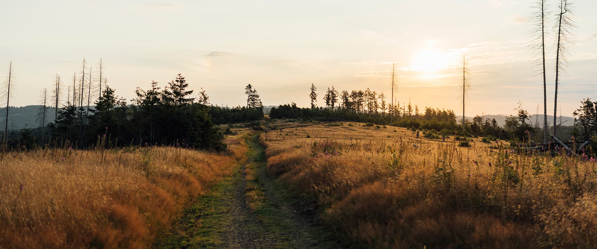
Leaving Winterberg on stage three, you will walk straight into higher ground, a good wake-up for the day. You will climb onto the Kahler Asten and follow the wide ridge trails through the uplands. You will pass Neuastenberg and Langewiese, where the farmland will meet forests again. You will also pass a fresh water spring (Ruhrquelle) for a break. The trail will stay high above the valleys, and you will walk long, smooth sections before reaching Schanze for the night.

Schanze is a beautiful small town, and you can camp here at the Almhütte. From Schanze, you can choose between 2 Rothaarsteigs paths, just check the signs or the original map. If you descend into the Grubental on narrow paths through the forest, you will follow a small stream before climbing back to the ridge near Latrop. Afterwards, you can have lunch at Schäferhos, a beautiful family-owned spot with regional food. Then, from there, you will hike across open high countryside and continue toward the Rhein-Weser Tower. This part is really beautiful as the meadows and mixed forest will frame the views while you hike across the backbone of the Rothaar Mountains.

After the Rhein-Weser Tower, you will descend into the Schwarzbach Valley and follow smaller side valleys. You will climb again toward the Heinsberger Heide and cross hilly terrain. Then, you will scale the Giller and walk up to the Giller Tower, where you will get beautiful views before continuing toward Lützel near Hilchenbach.

From Lützel, you will walk toward Lahnhof through quiet Siegerland forest. This is where you will reach the source region of three major rivers. You will pass the Sieg Spring first, then Eder Spring, and then follow the old trade routes toward the Lahn Spring. You will finish this stage at the source of the Lahn near Lahnhof, one of the best-known landmarks on the Rothaarsteig.

On the seventh stage, as you leave Lahnhof, you will hike along narrow trails and old boundary tracks toward Wilgersdorf. You will pass Ilse Spring and walk along sections of historic stone paths. Here, the ridgelines will alternate with meadow crossings to give you some variety, and the beech trees will show you where the old borders were. You will descend gradually into Wilgersdorf as the hills begin to soften.

Finally, on the last day from Wilgersdorf, you will follow forest paths toward the Dill Valley. You will pass the Lucaseiche natural monument, a beautiful beech forest, and cross low ridges before your final descent into Dillenburg, where you will finish the Rothaarsteig in the old town.

Stages

The Rothaarsteig is traditionally split into 8 stages, which are below. Most people follow these stages, but of course, you can choose to hike this trail at your own pace and edit them as you see fit. With the many accommodations and villages along the route, there are opportunities to make it your own.

Rothaarsteig 8-Stage Itinerary

Stage 1:

Brilon – Willingen, 23 km | 14.3 mi

Stage 2:

Willingen – Winterberg, 22 km | 13.7 mi

Stage 3:

Winterberg – Schanze, 18.8 km | 11.7 mi

Stage 4:

Schanze – Rhein-Weser-Turm, 23.5 km | 14.6 mi

Stage 5:

Rhein-Weser-Turm – Lützel, 18.4 km | 11.4 mi

Stage 6:

Lützel – Lahnhof, 14.2 km | 8.8 mi

Stage 7:

Lahnhof – Wilgersdorf, 18.4 km | 11.4 mi

Stage 8:

Wilgersdorf – Dillenburg, 20.4 km | 12.7 mi

Accommodations

Throughout the Rothaarsteig, you can stay in lodgings and accommodations in each town along the way. You will always have the option to book something ahead of time. However, camping on the Rothaarsteig is also possible at the designated campsites in the region.

Best time of the year

The best time of the year to hike the Rothaarsteig is spring through early autumn. This is when you will have the best weather, and any residual snow will be gone. Of course, in the high-summer between July and August, there is a higher likelihood of busier trails as people take their holidays. However, the only real consequence of that is you may need to book your accommodations a bit further in advance.

Safety & Gear

The Rothaarsteig is a great trail for beginning long-distance hikers and experienced hikers alike, as you can sleep in accommodations along the way, and resources are never too far. However, you still need to prepare before you hit the trail! To prepare for the Rothaarsteig, try packing clothing that can handle multiple types of weather and lots of layers. Hiking in the forest can be cooler, and then when it’s time to climb the hills on each stage, you’ll warm up very fast.

Additionally, it is always a good idea to pack a first aid kit (and know how to use it), an extra battery pack in case your navigation device dies (and the cords to charge it), and a waterproof cover for your backpack, just in case you have some afternoon showers as you walk.

Finally, the Rothaarsteig can have challenging days, like when you climb to the highest point in North Rhine-Westphalia, the Langenberg, so it is good to have a basic level of cardio fitness and endurance before you begin this hike. You can train this by taking test hikes or runs on trails, working on your balance, and forcing yourself outside even in uncomfortable weather to work on your mental stamina.

Difficulty

The Rothaarsteig is a moderately difficult trail because of the daily elevation gain and descent. Over 8 days, you will climb around 3500 meters, which is about 400 per day. This can take a toll on your body, especially when carrying a heavy pack. However, with some training beforehand and a basic level of fitness, the average person should be able to manage this without any issues.

Good to know

The Rothaarsteig is one of Germany’s Top Trails, which is an award given only to 13 trails in Germany. Because of that alone, you know this will be a great hike! A benefit of the Rothaarsteig is that, with so many villages along the way, you can start or stop at any point. This means you can section hike it easily, or if you need to end early, there are easier options than some more remote trails.

Route
Point-to-point
Highest point
843m (2765 ft)

Want to submit a trail or make this page more complete?

Always read the disclaimer

Terms of Use: important to all visitors on this website. We strive to publish high quality content and information on this website. However it’s always possible that we’re missing out on some crucial information. In spite of the fact that this route, associated GPS track (GPX and maps) were prepared under diligent research by the specified contributor and/or contributors, the accuracy of such and judgement of the author is not guaranteed. Therefore, hiking-trails.com and contributors are in no way liable for personal injury, damage to personal property, or any other such situation that might happen to individuals hiking or following this route. Should you choose to hike this trail, this is always at your own risk. Check out our guidelines for safety hiking and Leave No Trace principles at the hiking 101 page.

Download GPX

Join the community!

Login or create a FREE account 😊

With an account you can:

Download GPX files

Pin trails to your wishlist

Mark trails as hiked by you

Rate hiking trails

Comment on trails, blogs and gear reviews

Happy trails!
Login

Don't have an account yet? Register here