About the Patundas Meadows Trek

country
Pakistan
length
22 km(14 mi)
Type of trail
Long-distance
difficulty

Difficulty is highly personal. Be aware of the weather conditions as bad weather turns easier trails in difficult trails especially in the mountains.

Moderate
accommodation

Lodging means a mix of hotels, hostels or AirBnB’s.

Camping, Shelters
Elevation gain
2300 m(7546 ft)
terrain
Mountains
remoteness
Some of the time
Show more

The Patundas Meadows Trek is a relatively low-effort, high-reward three-day trek crosses Passu glacier to reach a shepherd’s meadow that is home to some extraordinarily lucky herds. The plateau lies on the spine of the Karakoram range and is ringed by at least four 7000-meter behemoths – Shispare, Passu I and II, and Batura – as well a generous spread of 6000-meter giants.

Opposite the Passu side of the meadows sits the 57-km long Batura Glacier, one of the world’s largest glaciers outside of the polar regions. The trek is considerably easier and shorter than most alpine mountaineering expeditions in the region, making it an ideal choice for those uninterested in a week or multi-week expeditions, but still in want of a high alpine adventure.

Alia Ai-Ming Shahzad profile picture

Alia Ai-Ming Shahzad

After heading south on the PCT in 2023, Alia backpacked through South and Southeast Asia in search of treks that promised a heartily-spiced meal at the finish line. She’s currently living in Amman and section-hiking bits and pieces of the Jordan Trail. You can read about her latest ambles on Substack: @alughobi.

View profile

The Trail

The trail is 24 kilometers out and back, plus or minus some change depending on the path to cross Passu Glacier. The elevation change measures about 2200 meters from Borith Lake to the meadows’ high point (4,700 meters).

The first stage usually starts at or slightly past Borith Lake and leads with low to moderate steepness up to the glacier’s crossing point. It then descends down and across the glacier, and then back up to the lower camp, Latur (3,500 meters). Shepherds’ huts are available here if you opt not to bring your tent.

The second stage begins from Latur and leads up a steep face to the meadows themselves. The tough ascent eases as you approach the first crest where you’ll be treated to early views of the encircling mountains. You’ll find the entry point to the meadows marked by a shepherd’s hut (4,200 meters). After another few kilometers of more gentle ups and downs, the trail reaches 4,700 meters. You can choose to stay at the hut in the meadows for the night and enjoy sunset and sunrise views, or descend and sleep at a lower and more comfortable elevation at Latur.

The third stage of the Patundas Meadows Trek retraces the trail back to Borith Lake. It’s best not to underestimate the difficulty of this section. You will still have to re-cross the glacier, and it’s possible that the path you took just a few days ago is no longer viable, requiring you and your guide to find an entirely different route.

Stages

The Patundas Meadows Trek is normally hiked in three days, but doable in two days if one climbs up to the meadow on the first day, sleeps in the shepherd’s hut (4,200 meters), then proceeds to descend back to Borith on the second. However, this leaves less time to enjoy the view from the meadows themselves. Some have also completed the trail in a single day, but this is not recommended.

3-day Patundas Meadows Trek itinerary

Stage 1:

Borith Lake – Latur camp,  8 km | 5 mi

Stage 2:

Latur Camp – Patundas – Latur Camp, 8 km | 5 mi

Stage 3:

Latur Camp – Borith Lake, 8 km | 5 mi

Accommodations

You can choose between carrying your own tent and sleep system or asking your guide to bring equipment to bunk in the shepherd’s huts along the way. The huts lack running water, though sleeping pads and primitive fireplaces are often available.

For the nights prior to and following the last stage of the hike, accommodation is available at the nearby villages of Ghulkin and Gulmit.

Accommodation per stage

Stage 1:

Latur

Stage 2:

Latur or Patundas Meadows

Stage 3:

Return to Ghulkin or Gulmit Village

Best time of the year

The best time of the year to hike the Patundas Meadows trail is June to August. Flights from Islamabad to Gilgit, the nearest city, are subject to random cancellation this time of year; expect to wait a few days for the next outbound flight if yours is delayed, or make alternate arrangements to hire a car instead.

Always check trail conditions and local weather forecasts before starting an alpine glacial hike. Make sure to consider your hiking experience, skill level, and comfort when evaluating glaciers. As mentioned, the trail is most safely completed with the support of a guide.

Safety & Gear

As mentioned, the crossing of Passu Glacier can be quite treacherous. The trail shifts every few days – and sometimes even overnight – according to glacial drift and melt. Taking a guide with you both ensures your safety and supports the locals who maintain the trail, making this hike possible. Your guide will also have updated knowledge about the glacier section; the path across is re-routed and haphazardly remarked frequently. Also note that the surface of the ice can be quite slippery, particularly after rainfall, and ice spikes or crampons are a must for most foreigners. Trekking poles can also be useful to prevent or arrest falls.

The Patundas Meadows Trek is quite remote and requires additional considerations. Carry a well-stocked first aid kit as medications are not always readily available in local pharmacies. Be sure to bring diarrhea and ideally giardia medication, as both are rights of passage for the foreign stomach. Bringing a water filter and purification tablets — and insisting your guide use both when washing pots and cooking – reduces giardia risk. If anything goes awry, local rescue teams and the Pakistani army have experience with expedition rescue efforts, though, of course, these may not arrive as quickly as rescue services in the Western world. Registering with private helicopter rescue services is also possible, though cost-prohibitive if the service is rendered.

It is not a bad idea to check the news and security advisories before one travels to the region. In particular, recent attacks against Chinese nationals have spiked due to tensions surrounding Chinese investment in Pakistan. As a hiker of East Asian descent myself, I felt quite safe in Gilgit Baltistan – no violence of this sort has occurred in G-B, which enjoys a close relationship with China – but East Asian-appearing hikers should stay aware of these risks.

Difficulty

The Patundas Meadows Trek is moderately challenging. It is relatively short and, while steep in parts, considerably easier terrain than most alpine mountaineering treks in Northern Pakistan. This makes it an ideal choice for those pressed for time or simply not interested in week or multi-week expeditions but still in want of a high alpine adventure. Nonetheless, there are still two considerations you should take into account before deciding to hike the trail:

Firstly, the glacier crossing, which is undoubtedly the most challenging section of the hike. Slim cracks in the ice might crack open suddenly, and randomly interspersed gaps and walls in the glacier block forward progress. Your guide should know how to navigate around these obstacles safely, but you must still be comfortable with stepping over deep crevices and maneuvering over slippery, icy surfaces.

You can also expect sections of exposed and unstable scree where rock slides have washed out small sections of the trail. While navigating over the treacherous loose rock below, you’ll also have to keep an eye out for movement on the peaks above, as there remains high potential for avalanches in these areas.

Good to know

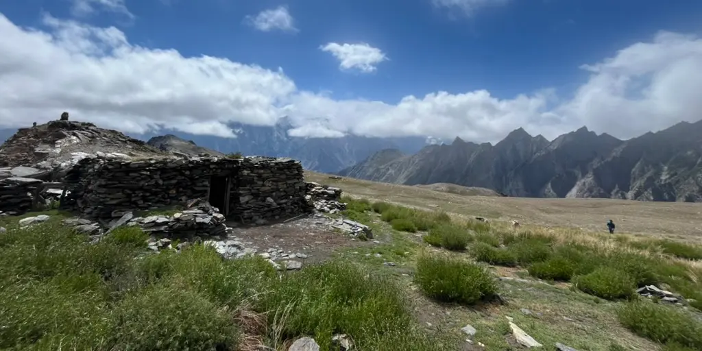
Travelers usually stay the night before and after the trek in the neighboring village of Gulmit (expect comfortable tourist-geared lodges, such as the Silk Route) or Ghulkin (expect homestays and a more local experience).

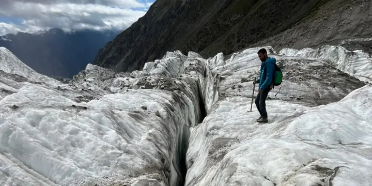
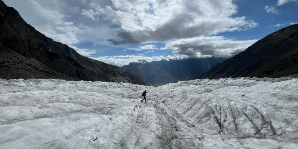
It’s best to source your guide from one of the neighboring villages, Ghulkin or Passu. Guides from different villages in the north are less likely to be familiar with the glacial crossing. See the useful links for a recommended guiding company, though any based in the area should serve you well. The expedition can be arranged on arrival to the upper Hunza Valley with little to no advance warning, though it doesn’t hurt to reach out a bit earlier. Prices are reasonable and often include food services and gear.

In terms of transportation, flights are available from the capital city of Islamabad to Gilgit. Flights from Islamabad to Gilgit, the nearest city, are subject to random cancellation this time of year; expect to wait a few days for the next outbound flight if yours is delayed, or make alternate arrangements to hire a car instead. Adventurous travelers with some time on their hands might also attempt to make use of the local bus system.

The local people are Wakhi, of Pamiri nomadic herdsmen descent. Most are highly educated and many speak English fluently – don’t be surprised if your guide is also an engineer, or working remotely for a US-based company. The Hunza Valley and Upper Hunza in general are quite accustomed to seeing foreigners, although the communities maintain their own cultural and religious identity proudly. Women traveling solo will feel comfortable in the region even without a headscarf.

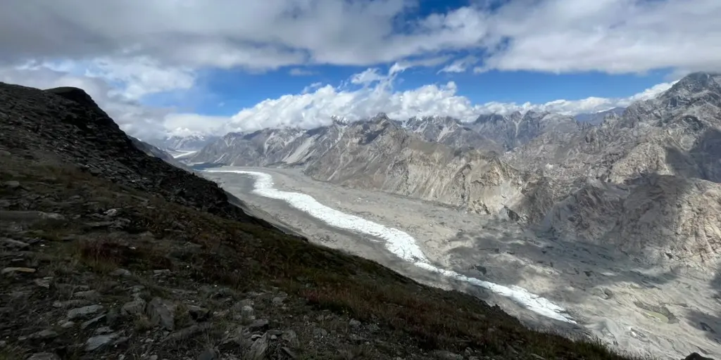
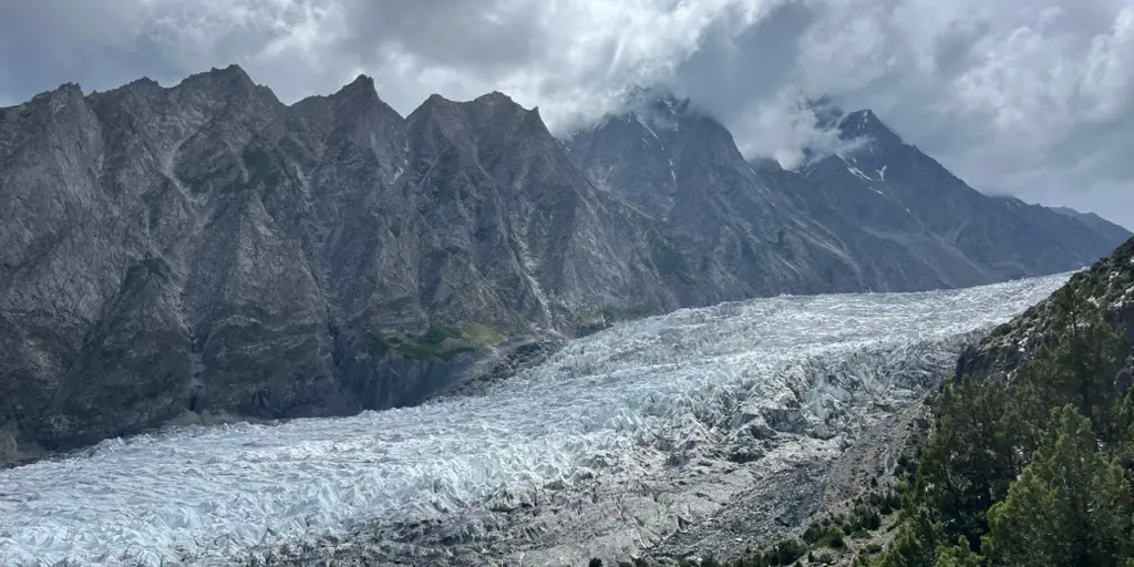
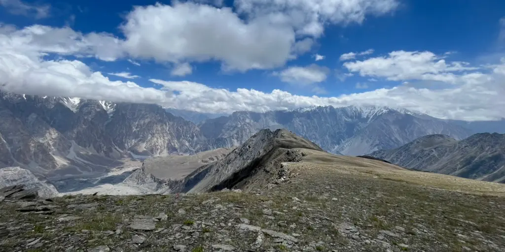
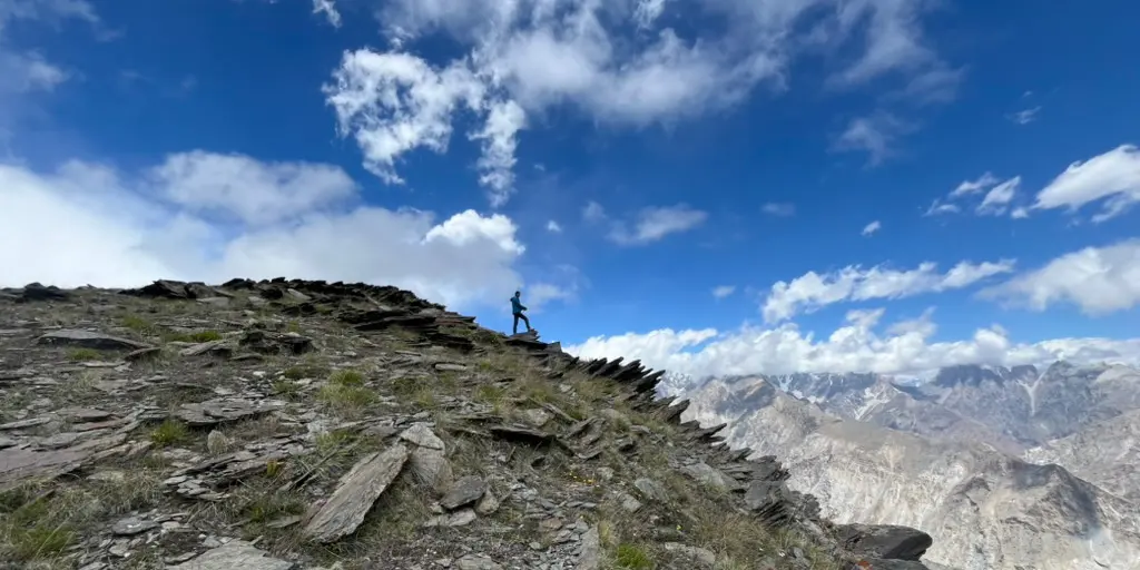
There are water points before the glacier crossing, though flow availability changes with the season. At the meadows themselves, water is available following a heart-stopping scramble down the cliffside toward Batura glacier. Your guide will know where to look.

route
point-to-point
highest point
4.700m (15.420 ft)

Want to submit a trail or make this page more complete?

Join the community!

Login or create a FREE account 😊

With an account you can:

Download GPX files

Pin trails to your wishlist

Mark trails as hiked by you

Rate hiking trails

Comment on trails, blogs and gear reviews

Happy trails!
Login

Don't have an account yet? Register here