About the Laugavegur Trail

country
Iceland
length
53 km(33 mi)
Type of trail
Long-distance
difficulty

Difficulty is highly personal. Be aware of the weather conditions as bad weather turns easier trails in difficult trails especially in the mountains.

Moderate
accommodation

Lodging means a mix of hotels, hostels or AirBnB’s.

Camping, Mountain huts
Elevation gain
1700 m(5577 ft)
terrain
Mountains
remoteness
Some of the time
Show more

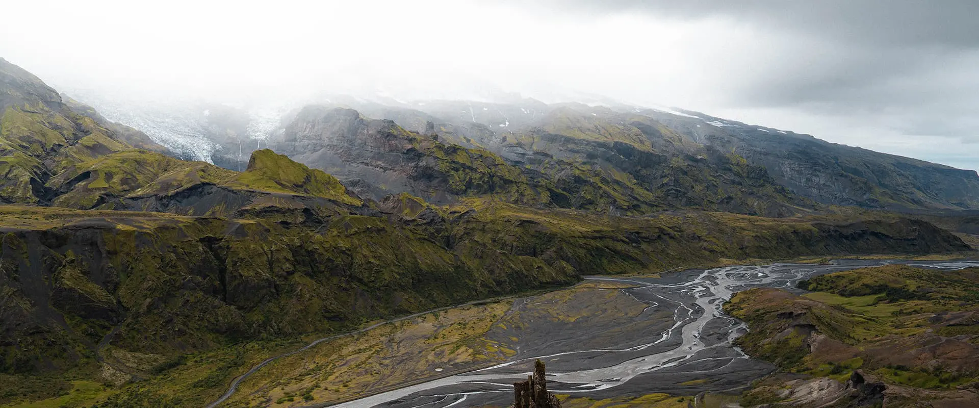
Meet this magical trail on one of the most beautiful countries on earth: the Laugavegur Trail. This 4-day trek in Iceland, spanning approximately 53 kilometers, is a great experience for worldwide hikers who lead you from Landmannalaugar to Þórsmörk, making it an ideal adventure for both novice hikers and experienced hikers. The Laugavegur Trail is one of the most popular trails in the world and presents a unique opportunity to traverse through Iceland’s diverse landscapes, including rhyolite mountains, black sand lava fields, hot springs, deep green mountains, and more.

Iceland, often referred to as the “Land of Fire and Ice,” is an island nation that stands as a testament to the raw, untamed power of nature. High up in the North Atlantic, this country is well known for its cinematic landscapes and roaring volcanoes, glaciers, gushing geysers, and rugged lava fields. Despite its proximity to the Arctic Circle, Iceland is warmed by the Gulf Stream, resulting in a surprisingly mild climate that allows for vibrant green landscapes, especially during the summer months.

Editor

Elmar Teegelbeckers

Passionate hiker Elmar spends months of his time on the trail. He’s usually on the lookout for hidden gems in one of his favourite countries such as Slovenia, Switzerland and Japan. He founded hiking-trails.com in need for a community and detailed information about the trails. Before this, he worked for the Alpine asscociation in the Netherlands[ (NKBV) but lost his heart to the trails.

With this website and socials, he hopes to shape an inclusive community for hikers all over world. No matter your speed, experience or level, you can get out there to enjoy the trails and connect with the heartwarming hiking community. Life is so much better outside and he hopes to inspire hikers to take their first, or next, step on the trail.

View profile

The Trail

The trail kicks off at Landmannalaugar, accessible by a bumpy bus ride from Reykjavik. Your journey begins amidst vast lava fields, guiding you through a wonderland of geological marvels from snow-draped highlands to the changing colors of the mountains.

The next day you’ll ascend through a landscape of lava flows and geothermal wonders, setting up camp at Hrafntinnusker or pushing on to Álftavatn if you’re up for a longer trek. You can combine stage 2 and stage 3 if you’re up for a bit of a longer hike.

The great thing about the Laugavegur trail is the transitions of the landscape, now from the contrasting scenery of dark lava fields and mossy mountains, descending to the picturesque Álftavatn, known as Swan Lake.

Further on, you’ll hike through a lunar-like landscape of lava that opens up to the vistas near Emstrur, with a detour to the Markarfjót river canyon offering great views. The last day you set foot to Þórsmörk, with its birch forests offering a rare glimpse of woodland in Iceland, marking a serene end to the epic journey.

Extend to Skogar on the Fimmvörðuháls trail

For those who want to get a bit more of Iceland, the trail can be extended to Skógar on the Fimmvörðuháls trail offering an additional one or two-day trek through less busy hiking trails and showcasing even more of Iceland’s scenic diversity.

Stages

Stage 1:

Landmannalaugar – Hrafntinnusker, 12 km | 7 mi

Stage 2:

Hrafntinnusker – Álftavatn, 12 km | 7 mi

Stage 3:

Álftavatn – Emstrur, 16 km | 10 mi

Stage 4:

Emstrur – Þórsmörk, 16 km | 10 mi

Accommodations

Hiking on the Laugavegur Trail will give you some options where to sleep. There are mountain huts available after the end of every stage, however, the mountain huts are always fully booked already by the beginning of the year for July and August. Most hikers choose therefore to stay on the campsites, next to the mountain huts. This means that you need to carry your gear or choose a luggage transfer option.

Alongside the trail, the campsites offer some basic amenities like toilets and sometimes even showers. Sometimes there’s even a small shop or restaurant, mostly very basic so bring all necessary supplies with you. You don’t need to reserve the camping spots in advance.

Overnight per stage

Stage 1:

Landmannalaugar

Stage 2:

Hrafntinnusker

Stage 3:

Álftavatn

Stage 4:

Emstrur

Stage 5:

Þórsmörk

Best time of the year

If you’re hiking the Laugavegur trail, you’re bound to the summer months. The best time to hike the trail is July and August, though it’s wise to prepare for unpredictable weather, including possible snow blizzards and strong winds even in these months. You should only hike this trail in the off-season if you’re seriously prepared for harsh winter conditions.

Safety & Gear

Hiking in Iceland offers some of the most stunning and varied landscapes on the planet, from glaciers and volcanoes to waterfalls and geothermal springs. However, the rugged terrain and unpredictable weather conditions require careful preparation and respect for safety guidelines.

Equip yourself with layers, including a reliable wind- and waterproof jacket, and consider pre-booking mountain huts for a comfortable night’s rest. The most important thing while hiking in Iceland is that you be aware of the harsh weather conditions which are also possible in the summer season. Snow blizzards or heavy rain with a cold wind are always a possible threat, so bring your hardshell layers and know how to deal with such weather.

River crossings

On this trail, you’ll face some river crossings. Make sure you’re okay with this and bring your water shoes and hiking poles which make the river crossings safer and easier.

Good to know

The Laugavegur Trail is one of the most popular hiking trails in the world. Because of the dramatic, beautiful, and serene landscape, it will feel like you’re hiking on another planet. If you want to stay in the mountain huts, book months in advance, they fill up pretty quickly. If you’re not familiar with hiking in harsh weather conditions, consider a group tour with a tour guide as a possibility. Some of the time, you can buy resupplies at the campsites but you’ll need to bring most of your food and snacks with you for this trail. You can fill up your water bottle in the streams but always carry a filter.

Route
Point to point
Highest point
1050m (3440 ft)

Guidebooks

cover guidebook

Trekking in Iceland

View guidebook

Want to submit a trail or make this page more complete?

Comments

Be the first one to comment on this trail!

Reply to this trail

Your email address will not be published. Required fields are marked *

Reply to this trail

Log in to comment on this trail
Always read the disclaimer

Terms of Use: important to all visitors on this website. We strive to publish high quality content and information on this website. However it’s always possible that we’re missing out on some crucial information. In spite of the fact that this route, associated GPS track (GPX and maps) were prepared under diligent research by the specified contributor and/or contributors, the accuracy of such and judgement of the author is not guaranteed. Therefore, hiking-trails.com and contributors are in no way liable for personal injury, damage to personal property, or any other such situation that might happen to individuals hiking or following this route. Should you choose to hike this trail, this is always at your own risk. Check out our guidelines for safety hiking and Leave No Trace principles at the hiking 101 page.

Download GPX

Join the community!

Login or create a FREE account 😊

With an account you can:

Download GPX files

Pin trails to your wishlist

Mark trails as hiked by you

Rate hiking trails

Comment on trails, blogs and gear reviews

Happy trails!
Login

Don't have an account yet? Register here