About the Laguna Negra Trail

country
Spain
length
20 km(12 mi)
Type of trail
Hut to hut, Long-distance
difficulty

Difficulty is highly personal. Be aware of the weather conditions as bad weather turns easier trails in difficult trails especially in the mountains.

Moderate
accommodation

Lodging means a mix of hotels, hostels or AirBnB’s.

Mountain huts
Elevation gain
890 m(2920 ft)
terrain
Mountains, Hills
remoteness
Some of the time
Show more

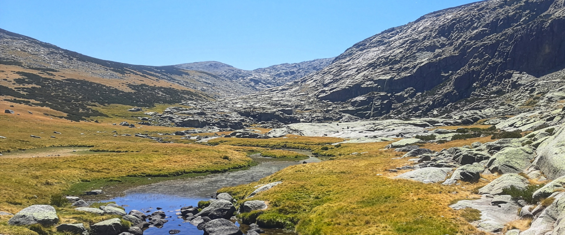
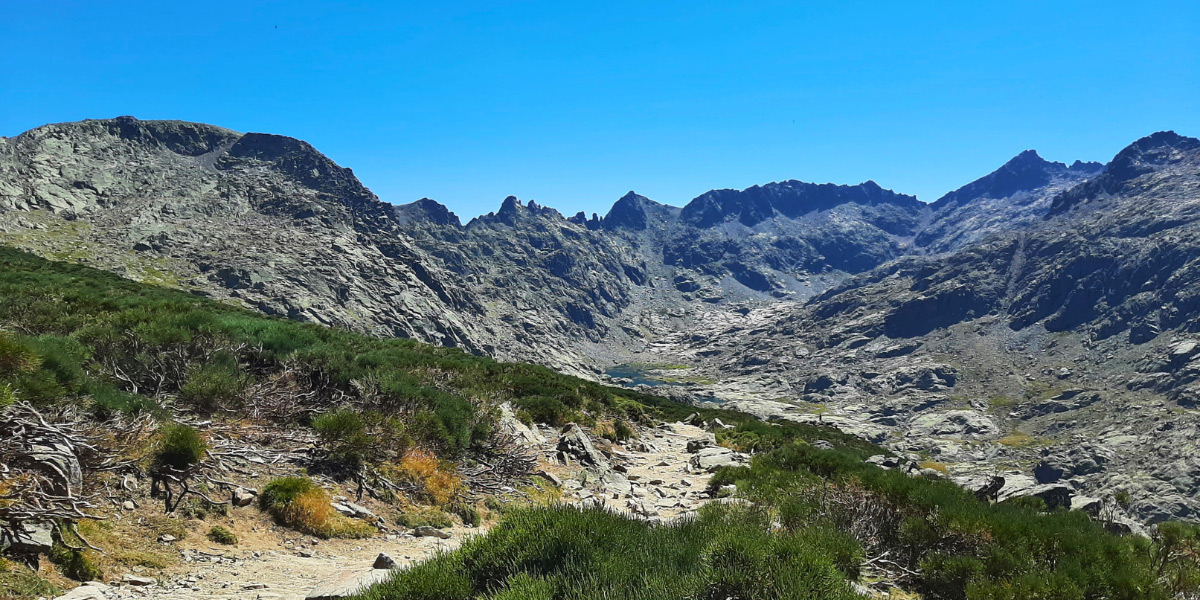
The Laguna Negra trail is one of the most popular routes in the beautiful Sierra de Gredos mountains in central Spain. Just a 3-hour drive from Madrid, there is a protected regional park with rugged peaks, deep valleys, and glacial lakes that are comparable to the famous Pyrenees.

This trail, half marked and prepared and half wild and adventurous, is the perfect break to get into the Sierra, disconnect for a night in a Spanish mountain refuge, and hike back. The route is 20 kilometers long and is divided into 2 stages that form a loop, returning to where you parked your car at La Plataforma.

Irene Fernandez profile picture

Irene Fernandez

Irene Fernandez grew up in Spain in a region with nearly 0 mountains. So, when she got a taste of the mountains at age 19, she discovered a whole new world. With a 9-5 as marketing manager, she spends her free time bookmarking routes and planning getaways to “touch grass.” Few things make her happier than getting to an Austrian mountain hut after a long hiking day and ordering a weissbier and a brettljause.

View profile

The Trail

The first day, the very well-marked route departs from La Plataforma trailhead, the last place to leave your car before adventuring into the Sierra. The trail ascends for 3.5 kilometers through a very well-kept route that is frequented by day hikers. After the 3.5 km mark, you will get to a viewpoint from which to admire the valley below and spot the iconic Spanish Ibex that live in these mountains.

After the viewpoint, you will leave the day hikers behind and start your descent towards the “Laguna Negra” or Black Lake. The trail descends for another 3.5 km, following the left side of the lake until the very end, when the route steers right to get to the Refugio Laguna Grande mountain hut. Dip your feet in the water and enjoy the surroundings before a family-style mountain hut dinner and a well-deserved rest.

The second day brings two possibilities: hike back where we came on the first day (7km) or adventure through a route that will take you past abandoned grazing areas, a hanging bridge, and some unmanned emergency shelters (13km).

To take the second route, you will pass the mountain hut and continue bordering the lake in the opposite direction from yesterday, to follow the river down. You will cross the river several times as it starts to get bigger and begins to form a gorge. After the hanging bridge, you will abandon the glacial landscape to walk the last kilometers through pastures and grazing areas where you will find dispersed shepherd shelters in different states of abandonment. This route is not as well-marked and prepared as the first route, so it is essential to use a combination of maps, GPX, and common sense. The red-white and yellow-white marks of long-distance trails will lead you through a path that is 90% of the time unmissable.

Stages

The trail is hiked in 2 days, with a possibility to follow a longer route on the second day instead of hiking back on the same route as the first day.


Laguna Grande Trail 2-stage itinerary

Stage 1:

La Plataforma – Refugio Laguna Grande, 7 km | 4.4 mi

Stage 2:

Refugio Laguna Grande – La Plataforma (through Garganta de Gredos and Roncesvalles bridge), 13 km | 8 mi

Accommodations

This trail will take you to the Laguna Grande mountain hut (formerly Refugio Enola, if you have an old map). It is necessary to book in advance, especially in the summer months. The hut offers half board or full board, including a picnic lunch. Lodging is available in 3 bunk rooms with space for 66 hikers. There are blankets and pillows available, but the use of a liner is compulsory. For those packing light, there are camp shoes available. In the summer, solar showers are available if there isn’t a drought period. There is no cell reception or Wi-Fi in the hut or surroundings, so make sure your maps are loaded.

Best time of the year

The best time of year to hike the Laguna Grande trail is in summer and early September, as that is also the mountain hut’s mail-opening period. Summers are often dry and very warm, so pack accordingly and bring enough water and sunscreen.

Evenings and mornings in the highest parts of the trail can be chilly. The hut doesn’t have a dry room in the summer, so pack extra socks. Always check the forecast before starting the day or consult with the hut warden.

Safety & Gear

Either trail runners or mountain boots are fine for this hike. Bring enough water, sunscreen, and a sun hat for the Spanish heat. A power bank and a paper map will be your allies in case the solar panels in the hut haven’t produced enough energy to charge all phones.

Navigating the route is easy via GPX. However, keep your eyes peeled for the path on day 2, as it is less well-marked than on day 1.

Difficulty

The trail is of medium difficulty, combining easy, well-prepared paths with clear signage, with narrow paths and rocky terrain where it’s essential not to lose orientation. Good shoes are a must, but warm and sturdy hiking boots are not a necessity, as a good trail shoe will also do.

Good to know

The Laguna Negra trail is also accessible in the winter months for alpinists and tour skiers. Many summer hikers and alpinists use the hut as a starting point for ascents to nearby glacial peaks. The summer weekends are busy. Book a midweek night for a more remote feeling. While the huts have some supplies for sale, it is recommended to bring your own snacks.

The mountain hut has enough water points. On the first day, there is a natural fountain around kilometer 4. Carry enough water for the second day’s hike from the hut.

Route
Circuit
highest point
2,177m (7142 ft)

Want to submit a trail or make this page more complete?

Always read the disclaimer

Terms of Use: important to all visitors on this website. We strive to publish high quality content and information on this website. However it’s always possible that we’re missing out on some crucial information. In spite of the fact that this route, associated GPS track (GPX and maps) were prepared under diligent research by the specified contributor and/or contributors, the accuracy of such and judgement of the author is not guaranteed. Therefore, hiking-trails.com and contributors are in no way liable for personal injury, damage to personal property, or any other such situation that might happen to individuals hiking or following this route. Should you choose to hike this trail, this is always at your own risk. Check out our guidelines for safety hiking and Leave No Trace principles at the hiking 101 page.

Download GPX

Join the community!

Login or create a FREE account 😊

With an account you can:

Download GPX files

Pin trails to your wishlist

Mark trails as hiked by you

Rate hiking trails

Comment on trails, blogs and gear reviews

Happy trails!
Login

Don't have an account yet? Register here