La Gomera GR132

GR 132 La Gomera

Camino Natural Costas de La Gomera

About the GR 132 La Gomera

Canary Islands
country
Spain
length
125 km(78 mi)
Type of trail
Long-distance
difficulty

Difficulty is highly personal. Be aware of the weather conditions as bad weather turns easier trails in difficult trails especially in the mountains.

Difficult
accommodation

Lodging means a mix of hotels, hostels or AirBnB’s.

Lodging
Elevation gain
6500 m(21325 ft)
terrain
Mountains, Coastal, Forest
remoteness
Most of the time
Show more

The GR132 around La Gomera is a beautiful and difficult hike. Every day, you climb into the mountains that form cliffs around the coast of the island, and descend down to the beaches around the edges. The climbs are steep, and at times the descents can be even steeper, but the views and trails themselves make this a fantastic hike.

La Gomera is an island that has been inhabited since at least 200 B.C., historians believe. It has a very interesting history of native people who came over from North Africa, of pirate raids, of it being Columbus’s final resupply stop before sailing for the Americas, and of Spanish conquest in the 1500’s. The hills are covered in prickly pear cactuses, abandoned agricultural terraces, and yucca plants that tower over you as you walk. The ruins of old farms and homes that you pass will immediately transport you back to how life must have been a hundred years ago, when the islanders still relied on their livestock and farms.

women in blue smiling at camera
Editor

Katie Mitchell

After a whirlwind 10 years on the road (and trail!), Katie has hiked the Camino Frances, the Peaks of the Balkans, the Fisherman’s Trail, the Cumbria Way, the Pembrokeshire Way, and more in Europe and the United States. She is an avid trail runner and you can find her either on the trail or in a cafe in a new city, sampling all of their gluten-free treats. You can follow her adventures on Instagram.

View profile

The Trail

Stage one begins in the capital of San Sebastián, where you’ll disembark the ferry from Tenerife. After walking through town and along the beach for a few meters, you’ll start the trail on an almost inconspicuous set of stairs hidden in an alleyway. From there, you’ll hike up and up through San Sebastian’s outskirts until you reach the actual dirt path and officially begin the hike. The trail is desertous and rocky as you make your way up about 500 meters. You’ll hike through the incredible valleys, dotted with palm trees, succulents, and yuccas as you climb. Eventually, you’ll reach a crossroads where you can either walk along a road with a large aqueduct pipe next to it, or continue on the path. The choice is yours, as the trail will eventually rejoin that road, and you’ll hike it for about 15 kilometers. However, don’t be discouraged, as “road” is a strong word for it. It’s more like a dirt 4×4 track that is occasionally paved. This will give way to a trail again that will take you down a steep descent to Hermigua, where you’ll spend the night.

The second day from Hermigua to Vallehermoso is beautiful (although, they all are). On this stage, you will begin climbing out of Hermigua and to Agulo, your first stop of the day, where you’ll pass some old abandoned farms. In Agulo, you’ll be able to stock up on water and snacks at the markets or even grab an early lunch at the restaurants in town. We particularly liked Bar-Zumeria Lila. From Agulo is where the real work begins. You’ll climb about 650 meters to the top of the Garajonay National Park, where you’ll find a lovely visitors center around kilometer 33. There are exhibits, a small cafe and water taps. Although I would not rely on these, as the tap was not working when we were there in February 2026. As you descend from the visitors center, the gradient becomes steep. You’ll jump between asphalt road and trail as you make your way to Vallehermoso. Plan about 3-4 hours for this, depending on how tired you are and how heavy your pack is. The last 4 kilometers before Vallehermoso are particularly beautiful as you hike around the Roque Cano and other rock formations and into town.

From Vallehermoso to Alojera is a great day where you take the Stage 3.1 variant through the forest until you reach the cliffs again. You have a feeling for what the GR 131 feels like, as you’re closer to the center of the island than on other stages. Vallehermoso is also where the GR 131 begins, or ends, depending on which direction you hike. But as you walk toward Alojera and exit the forest, you’ll begin to hike down, down, down on a very steep descent, until you reach town. You will sleep well after this day, no question about it.

From Alojera, you will hike back up the cliffs on a strenuous stretch toward Valle Gran Rey on stage 4, which is a great beach town with lots of amenities and is a good place to spend a rest day, if you wanted to elongate your time on the island a bit. You have great views once you finish the climb and will enjoy views of the ocean before you descend down once again to town.

GR132 La Gomera Vallehermoso
GR132 signpost

From Valle Gran Rey, you’ll now begin to hike right back out of the valley on a steep path that will skyrocket up about 500 meters. Be warned: it is exposed, and is not for anyone who has vertigo. It also has very little shade, so make sure to bring extra water! You’ll make it to the top of the initial climb and have a viewpoint with a bench for a well-deserved break. Then from there, you will have a nice flat walk through an oasis-like valley until you climb the final meters to the top. From the top, you’ll now descend on super gentle paths through what seems to be old agricultural land, on easier trails until you make your way down to La Dama. The descent is about 12 kilometers and will be a good rest for your body after all the climbing. However, don’t get it wrong: it’s still strenuous and you will have a final climb to La Dama. Enjoy a break at the Roqueiguala Restaurante and try the tortilla: delicious. It is important to note there are no accommodations in La Dama, where the official stage ends. Because of this, you’ll need to take a taxi or the bus to accommodation elsewhere nearby, and then return in the morning to continue the trail.

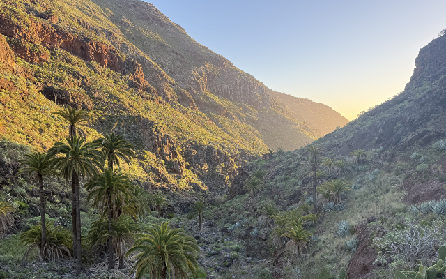
From La Dama on stage six, you will hike down a steep cliff to the old ruins of a fish cannery right up against the sea at La Rajita, and then climb right back up the cliff on the other side of the ravine. As you climb up, you’ll begin to see caves forming, and eventually it will open up into a wide plateau (still climbing uphill, of course), that will lead you to Arguayoda. If you need a break in the shade, this is the place for it. There’s a church where you can rest, or a covered barbecue area right as you enter the village. Once you leave Arguayoda, you will enter the Barranco de la Negra ravine. This is, hands down, one of the most beautiful sections of the trail. You’ll hug the cliffs as you hike past caves, house ruins, and old, overgrown, agricultural terraces. You will look down onto palm trees that are growing in the ravine and see the light hit the cliffs: beautiful. It’s easy to imagine the island hundreds of years ago as you hike through this section. And once you exit the ravine, you will walk along the road for a small bit before you reach yet another amazing ravine along Barranco Charco. This will take you up until you reach Alajeró. Stop for a mango juice at the La Vega restaurant and pat yourself on the back for a good day.

On the second to last stage of the trail, you hike from Alajeró to Playa Santiago. This day is a long, gentle descent. While it is more mild than the days before, it is still a difficult day! There is little to no shade as you hike, so you will want to start this one early. In total, you will descend about 800+ meters (2600 feet) over about 4-5 hours. Once you get to town, you’ll be treated to all sorts of amenities and shops.

Finally, on the last stage, you will hike from Playa Santiago to San Sebastián over 20 kilometers. The hike is characteristic of La Gomera in many ways: you’ll climb multiple cliffs and descend those same cliffs. You will get to walk on the beach and have the trails over plateaus completely to yourself, and you will ponder how the time went so quickly. At one point, about 3 hours before San Sebastián, you will come across a very interesting hotel resort, Hotel Finca El Cabrito, on the first of the two beaches you will pass. All guests here are brought in by speedboat and seem to form a tight-knit community (based on our quick, outsider observations). There are conflicting reviews from hikers on this hotel, some saying on the Google Maps reviews that it was not possible to get water, while we had a pleasant experience with the staff and found them welcoming as we took a break on the benches by the beach. As this is the only establishment throughout the stage, I would recommend carrying enough water for the full day and not planning to rely on the hotel, just to be safe. From there, you will have two smaller climbs (roughly 100 meters each), until you finally reach San Sebastián. Once you arrive to town, find a restaurant and order yourself some well-deserved tapas!

Stages

The official stages of the GR 132 divide the trail into 8 parts. However, we’ve known people who have extended it to a 2 week hike with lots of rest days, and people who have rushed it in 6 days. It is possible to hike the trail at your own pace, especially if you utilize the bus system to take you to accommodations each night and drop you back at the trail in the morning.

It should also be noted that many people combine the GR 132 and the GR 131, which runs the length of the center of the island, by skipping the second half of the GR 132 and diverting onto the GR 131. This is also a great option if you want to add more variety to your trail! However, each stage of the GR 132 is unique and an experience of its own. We would recommend doing them both separately to really enjoy each.

Official 8-stages itinerary

Stage 1:

San Sebastián – Hermigua, 27 km | 16.7 mi

Stage 2:

Hermigua – Vallehermoso (3.1 variant), 18 km | 11.2 mi

Stage 3:

Vallehermoso – Alojera (3.1 variant), 10 km | 6.2 mi

Stage 4:

Alojera – Valle Gran Rey, 11 km | 6.8 mi

Stage 5:

Valle Gran Rey – La Dama, 17 km | 10.6 mi

Stage 6:

La Dama – Alajeró, 12 km | 7.5 mi

Stage 7:

Alajeró – Playa Santiago, 10.5 km | 6.5 mi

Stage 8:

Playa Santiago – San Sebastián, 20 km | 12.5 mi

Accommodations

Accommodations on the GR132 are a bit tricky. While there are hotels or guesthouses at almost every stage ending, there are not many options. This means that they book out far ahead of time, and you will need to plan this trek far in advance in order to secure your lodgings for the trek.

Some people wild camp on this trail, but it is illegal in Spain to wild camp, and we came across a few rangers patrolling the trails in the evenings and late afternoon. Please respect the nature and book accommodations to keep this island such a magical place.

A quick tip for finding accommodations is to check Google Maps if you don’t see any showing up on Booking. From there, you can then call and ask about their availability. More often than not, you’ll need a base level of Spanish for this, as not everyone speaks English.

Best time of the year

The best time of the year to hike the GR 132 La Gomera is in the fall and winter. This trail is extremely exposed and has no shade, which means it can get incredibly hot. Because of this, November – March is the ideal time to be on the trail. By February, temperatures are already up to 20°C+ each day and the nights are a comfortable 16°C+. Any later than March, and the trail will be too hot to be safely hiked.

Safety & Gear

The most important thing to pack for the GR 132 is water. You will want to bring the option to carry up to 3-4 liters for each day as you hike. There are very few places to refill between towns, so you will need to carry it all with you. Kudos if you also bring electrolytes to replenish the minerals you will lose as you sweat. Additionally, layers to protect you from the sun, like a sun hoody, a hat, sunglasses and lots of sunscreen, will be very important.

When packing to hike around La Gomera, you will also want to bring a basic first aid kit, download the GPX to your phone, and bring an extra charger and headlamp just in case you end up being out there for longer than you expected. Additionally, it’s good to pack rain gear in the off-chance that it rains. Even though it is an island near the Sahara, in the winter months La Gomera does receive its fair share of precipitation.

Difficulty

The GR 132 on La Gomera is a strenuous trail. This cannot be understated. Following the traditional 8 stages, each day will take you, on average, 8 hours, and you will climb and descend roughly 1000 meters (3200 feet) per day. Additionally, the paths are often made up of loose stones and rocks, which require you to concentrate and have strong ankle balance as you hike, especially when you descend. Finally, the trail has very little shade, so you will need to carry 3+ liters per day to be on the safe side, which will give you a heavier pack. The trail also has some very exposed sections, and thus is not recommended for people with vertigo.

Good to know

Many people we met were combining the GR 132 with the GR 131, which runs the length of the island, from San Sebastián to Vallehermoso They hike from San Sebastián – Vallehermoso, and then come down on the GR 131 back to San Sebastian. While this is a great way to see both routes, it means missing the ravines on stage six. As this is one of the most beautiful sections of the trail, perhaps it would be better to hike the GR 132 clockwise before getting on the GR 131 at Vallehermoso. That way, you can see the west side of the island, which is, in my opinion, the most stunning.

The island is very well connected with buses, and at almost every bus stop there is also a sign with the number for a local taxi. If you need help, it’s easy to find.

Additionally, the path is very well signposted with markers every kilometer and signs at every cross in the path. It’s always good to have the GPX as backup, but the trail is very well-maintained!

Want to submit a trail or make this page more complete?

Always read the disclaimer

Terms of Use: important to all visitors on this website. We strive to publish high quality content and information on this website. However it’s always possible that we’re missing out on some crucial information. In spite of the fact that this route, associated GPS track (GPX and maps) were prepared under diligent research by the specified contributor and/or contributors, the accuracy of such and judgement of the author is not guaranteed. Therefore, hiking-trails.com and contributors are in no way liable for personal injury, damage to personal property, or any other such situation that might happen to individuals hiking or following this route. Should you choose to hike this trail, this is always at your own risk. Check out our guidelines for safety hiking and Leave No Trace principles at the hiking 101 page.

Download GPX

Join the community!

Login or create a FREE account 😊

With an account you can:

Download GPX files

Pin trails to your wishlist

Mark trails as hiked by you

Rate hiking trails

Comment on trails, blogs and gear reviews

Happy trails!
Login

Don't have an account yet? Register here