About the Camí Picasso

Catalonia
country
Spain
length
58 km(36 mi)
Type of trail
Long-distance
difficulty

Difficulty is highly personal. Be aware of the weather conditions as bad weather turns easier trails in difficult trails especially in the mountains.

Moderate
accommodation

Lodging means a mix of hotels, hostels or AirBnB’s.

Lodging, Camping, Mountain huts
Elevation gain
2670 m(8760 ft)
terrain
Mountains, Coastal, Forest, Hills
remoteness
Some of the time
Show more

The Camí de Picasso is a historic trail in Catalonia that retraces the steps of Pablo Picasso in 1906. The famous painter spent time in Gósol for a few months after walking from Guardiola de Berguedà to Bellver de Cerdanya with his companion, Fernande Olivier, a mule, and a mule driver. While taking a mule on the trail is less normal these days, it’s still possible to take the same route all these years later.

The trail and his time in Gósol are credited with changing Picasso’s painting style, which is reflected in the colors of his landscapes. Depending on your preferences, you can hike this path in 2-4 days.

women in blue smiling at camera
Editor

Katie Mitchell

After a whirlwind 10 years on the road (and trail!), Katie has hiked the Camino Frances, the Peaks of the Balkans, the Fisherman’s Trail, the Cumbria Way, the Pembrokeshire Way, and more in Europe and the United States. She is an avid trail runner and you can find her either on the trail or in a cafe in a new city, sampling all of their gluten-free treats. You can follow her adventures on Instagram.

View profile

The Trail

The route begins at the Guardiola station in Berguedà and climbs past the monastery of Sant Llorenç near Bagà. From here, the trail leads to the Coll dels Fangassos through steep country with rugged scenery, then drops into the Saldes valley. It crosses the river on an old lever bridge, passes the Castellot and the Molí de Bosoms, and crosses a torrent by way of a bridge left from the mining days before reaching Hostalets on the old royal road.

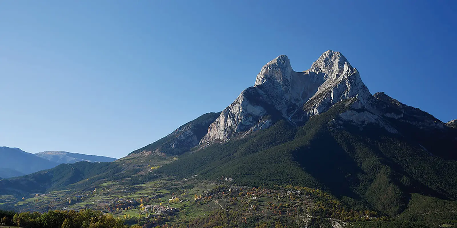
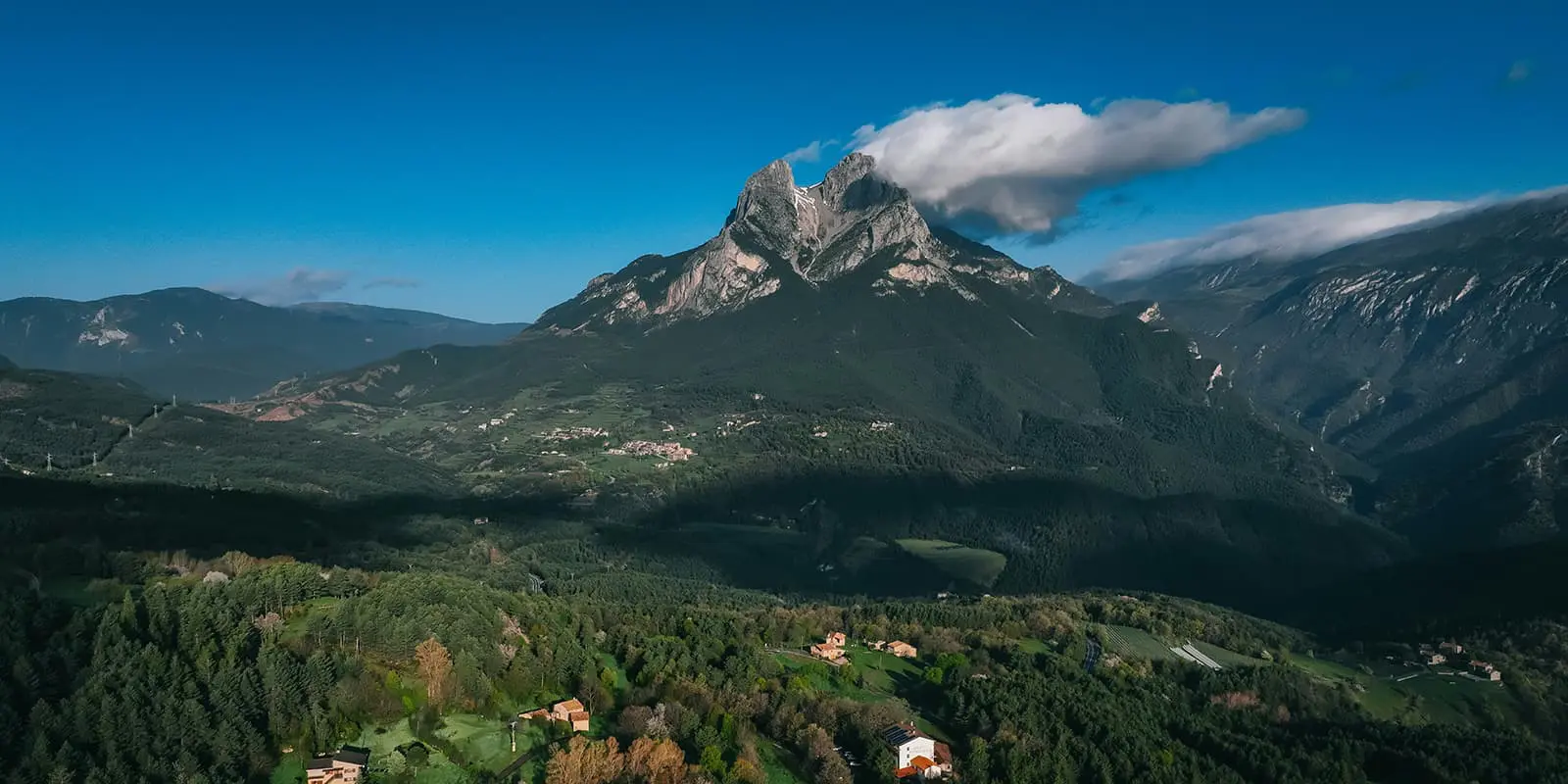
Beyond Hostalets, the path passes Cal Coix and climbs steadily toward the church of Sant Julià de Fréixens. The ascent continues more gently past Cal Francesc, where the chapel of Sant Antoni sits just off the route, before reaching Cal Susèn. From here, the views open to Maçaners and Pedraforca, whose distinctive silhouette will stay in sight for much of the walk.

At Maçaners, there is the option to detour to a spring before the route continues through Molers. It passes the medieval house of Sull, then climbs into the town where another fountain sits. The trail then runs along the Serra de Baix, joins the old coal road, and reaches the Molí de la Palanca on the Aigua Salada.

From here, the path heads to Saldes, crosses the town, and continues through the small neighborhoods of Cardina and Serrat. It crosses the main road to Gósol and follows the old road toward Feners and l’Espà. The restored path cuts across the clay cliffs of Coll de la Trapa and drops toward the torrent to rejoin the ancient road to Gósol. This section is striking: the eroded clay has left bare slopes in shades of red, ocher, and grey, a barren landscape of gullies and rock outcrops. It is easy to see why this scene influenced Picasso’s paintings so much.

After Coll de la Trapa, the trail crosses the road again and passes through l’Espà and Sorribes, both worth a short stop. From Sorribes, the path climbs to the Coll del Cap de la Creu with wide views of Gósol. Picasso arrived here in 1906 and later walked north to connect with the Camí dels Segadors, the historic trail used by locals to carry harvests across to Cerdanya in summer.

Leaving Gósol, the route heads north following the PR 124 waymarks. It passes the hamlet of Nas, then climbs a stony slope with broad views of the Gósol valley, the Aigua de Valls, and the Ensija range. The trail reaches the Coll de Font Terrers, where you’ll find a spring for water. From here, it crosses the Pla del Martí and continues gradually toward the Coma de Caners torrent. This is the access point if you’re aiming to reach Pedraforca by the Verdet route. The main path keeps to the forest edge before climbing steadily to Cap de la Portella.

Past the pass, the forest thins, giving way to open meadows with views into the Cerneres valley to the north. The route passes the Roca spring and climbs to Collell, a col that divides the waters of the Llobregat to the south and the Segre to the north. The track, a forest road closed in winter and dusty with traffic in summer, continues to the Pla de les Bassotes. This area takes its name from the small ponds scattered across the plain that serve as watering points for livestock.

From here, the route leaves the track and climbs again, passing the Prat Toixonés, the Costa del Clot dels Moros, and the Prat Socarrat before ascending to the ridge of the Serra Pedregosa. The final approach traverses toward the Clot de Palomar and reaches the Pas dels Gosolans, a notch between Comabona to the east and the jagged northern face of the Serra del Cadí. Below lies the Prat d’Aguiló, reached by zigzagging down stony slopes on the far side.

From the refugi, the path continues on a steep descent that eases into older linking tracks, passing the areas of les Eres, la Badaterra, and les Planes d’Hereus before reaching the villages of Nas and Pi. Near Pi, the way joins the GR 150, marked in red and white, and continues toward Talló. Here, an old forge has been restored as a small interpretation center where you can see how iron was once worked. Local lore suggests Picasso may even have stopped here to repair horseshoes on his journey. The final stretch climbs to Talló and then into Bellver, the endpoint of the route.

Stages

The Camí Picasso can be hiked at your own pace and is commonly walked in 2-4 days. You can either stay in lodging at the towns along the route or campsites, so you can choose your own itinerary.

Suggested 4-stage itinerary of the Camí Picasso

Stage 1:

Guardiola de Berguedà – Saldes, 20 km | 12.4 mi

Stage 2:

Saldes – Gósol, 11 km | 6.8 mi

Stage 3:

Gósol – Prat d’Aguiló, 12.8 km | 7.6 mi

Stage 4:

Prat d’Aguiló – Bellver de Cerdanya, 16 km | 10 mi

Accommodations

Accommodation is available in towns along the way, including Guardiola, Gósol, and Bellver, with options ranging from hostels and guesthouses to campsites and rural lodgings. Booking ahead is wise in summer and on weekends, when locals also use the trail. Something to note is that while the route passes through the Cadí-Moixeró Natural Park, wild camping is restricted in national parks in Spain.

Best time of the year

The best time of the year to hike the Camí Picasso is in late spring or early autumn. The weather is too hot in the summer, as the trail can be quite exposed. Hiking in May- June or September- mid-October will be cooler while still beautiful. It is best to check the forecast for the month and year you want to hike to be sure that the weather will be comfortable and not overly hot. Additionally, winter is not advised as the trail reaches almost 2500 meters above sea level and can be very cold.

Safety & Gear

It is important to prepare for the Camí Picasso by packing adequately. You’ll find it helpful to bring comfortable clothes that will protect you from the sun, as it can be an exposed trail. A suggested item to add to your hiking wardrobe for this is a sun hoody, which can have UV protection woven into the fabric and will keep you covered when there isn’t much tree cover. It’s also wise to make sure your shoes have good tread for the incline and descent.

Finally, be sure to pack enough water-carrying supplies (a reservoir, water bottle, anything you like), snacks for the trail, and a basic first aid kit. It’s always good to be prepared!

Difficulty

The Camí Picasso is a moderately difficult route because of its constant elevation gain until the peak at 2426 meters. While the trail is manageable when hiked over four days, halving it to hike in two days would make it difficult, with over 1000 meters of hiking per day. It’s best to train for the trail if you plan to attempt it in a short amount of time.

Good to know

Transport connections are straightforward at each end. Guardiola de Berguedà is accessible by bus from Barcelona and other towns in the Berguedà region. Bellver de Cerdanya is reached by bus from La Seu d’Urgell or Puigcerdà, both of which connect to regional train services. However, services between villages along the route are limited.

route
point-to-point
highest point
2.426m (7959 ft)

Want to submit a trail or make this page more complete?

Always read the disclaimer

Terms of Use: important to all visitors on this website. We strive to publish high quality content and information on this website. However it’s always possible that we’re missing out on some crucial information. In spite of the fact that this route, associated GPS track (GPX and maps) were prepared under diligent research by the specified contributor and/or contributors, the accuracy of such and judgement of the author is not guaranteed. Therefore, hiking-trails.com and contributors are in no way liable for personal injury, damage to personal property, or any other such situation that might happen to individuals hiking or following this route. Should you choose to hike this trail, this is always at your own risk. Check out our guidelines for safety hiking and Leave No Trace principles at the hiking 101 page.

Download GPX

Join the community!

Login or create a FREE account 😊

With an account you can:

Download GPX files

Pin trails to your wishlist

Mark trails as hiked by you

Rate hiking trails

Comment on trails, blogs and gear reviews

Happy trails!
Login

Don't have an account yet? Register here