About the Annapurna Circuit

Himalaya
country
Nepal
length
160 km(99 mi)
Type of trail
Long-distance
difficulty

Difficulty is highly personal. Be aware of the weather conditions as bad weather turns easier trails in difficult trails especially in the mountains.

Difficult
accommodation

Lodging means a mix of hotels, hostels or AirBnB’s.

Lodging
Elevation gain
6000 m(19685 ft)
terrain
Mountains
remoteness
Some of the time
Show more

The Annapurna Circuit in Nepal is a renowned trekking route that encapsulates the natural and cultural diversity of the Himalayan region. Encompassing a loop around the Annapurna massif, the circuit extends over 160-230 kilometers, depending on the starting and ending points. Trekkers traverse a variety of landscapes, from lush subtropical forests and paddy fields to high-altitude plateaus and arid valleys.

The trail crosses two river valleys and encircles the Annapurna range, reaching its highest point at Thorong La Pass, which stands at 5,416 meters. Along the Annapurna Circuit, hikers experience the rich cultural heritage of the Gurung, Manangi, and Thakali communities. The circuit offers breathtaking views of peaks like Annapurna I, Dhaulagiri, and Machhapuchhre.

You’ll have the option to sleep in teahouses along the way and experience the ancient culture of the Himalaya on this well-loved circuit. Be sure to slow down and have conversations with the people you meet to learn about the way of life and how tourism has impacted the area and how you can give back to the people that help you along the way!

black and white portrait photo
Author

Jérôme Servais

Jerome left everything he had behind in Belgium ten years ago and after a long trip reached Southeast Asia where he lived there for a couple of years. From Vietnamese rice terraces to Borneo’s deep jungles, from Mount Fuji to the Everest base camp, he hasn’t stopped moving since, always looking for new challenges and seeing as many wonders as he can. You can discover his photographer’s work and follow Jerome on Instagram here: @jerome_srv

View profile

The Trail

The Annapurna circuit was more “difficult” in the past and had a better reputation, and in recent years, people tend to say it has become easier and more accessible, which can attract less experienced hikers as well, for the best and the worst sometimes. Businesses tend to be less family-owned and turn more to profit, and overall now well-established tourism businesses bring a lot of convenience and attractiveness but tend to get rid of this authentic atmosphere and remoteness it was characterized by in the past. A newly built dirt road stretches now until Manang and sometimes covers the old hiking trail sections making it defacto the new Circuit of the Annapurnas or destroying it, but sometimes just crosses the hiking path, and the old trail appears almost as a “shortcut” from the car-centered path.

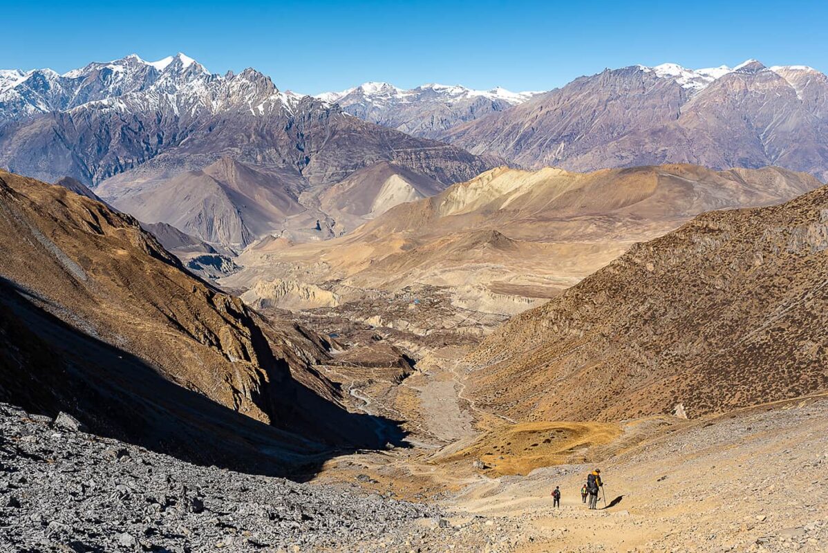
During my hike on the Annapurna circuit, I could see very little traffic and cars were not as a disturbance as I thought, but it was not the best path for hiking at first, and this can vary from one season to another I imagine. But later on, you can still find hidden gems, proof of older times when this trek was a pioneer in hiking in Nepal a few years back, and reach a proper Himalayan atmosphere, and this region still offers the most beautiful sceneries and landscapes you can easily access to.

You can organize your trip solo (at the time of speaking, please check regulations and if guides are required) or go through a tourist agency in Kathmandu or Pokhara, which will provide you with a package guide (not mandatory at the time of speaking) + porter (optional) + permits + transports. A guide costs roughly 25 USD/day (that is fixed for up to 6-8 persons) and also expects a baksheesh (tip) at the end of the trip.

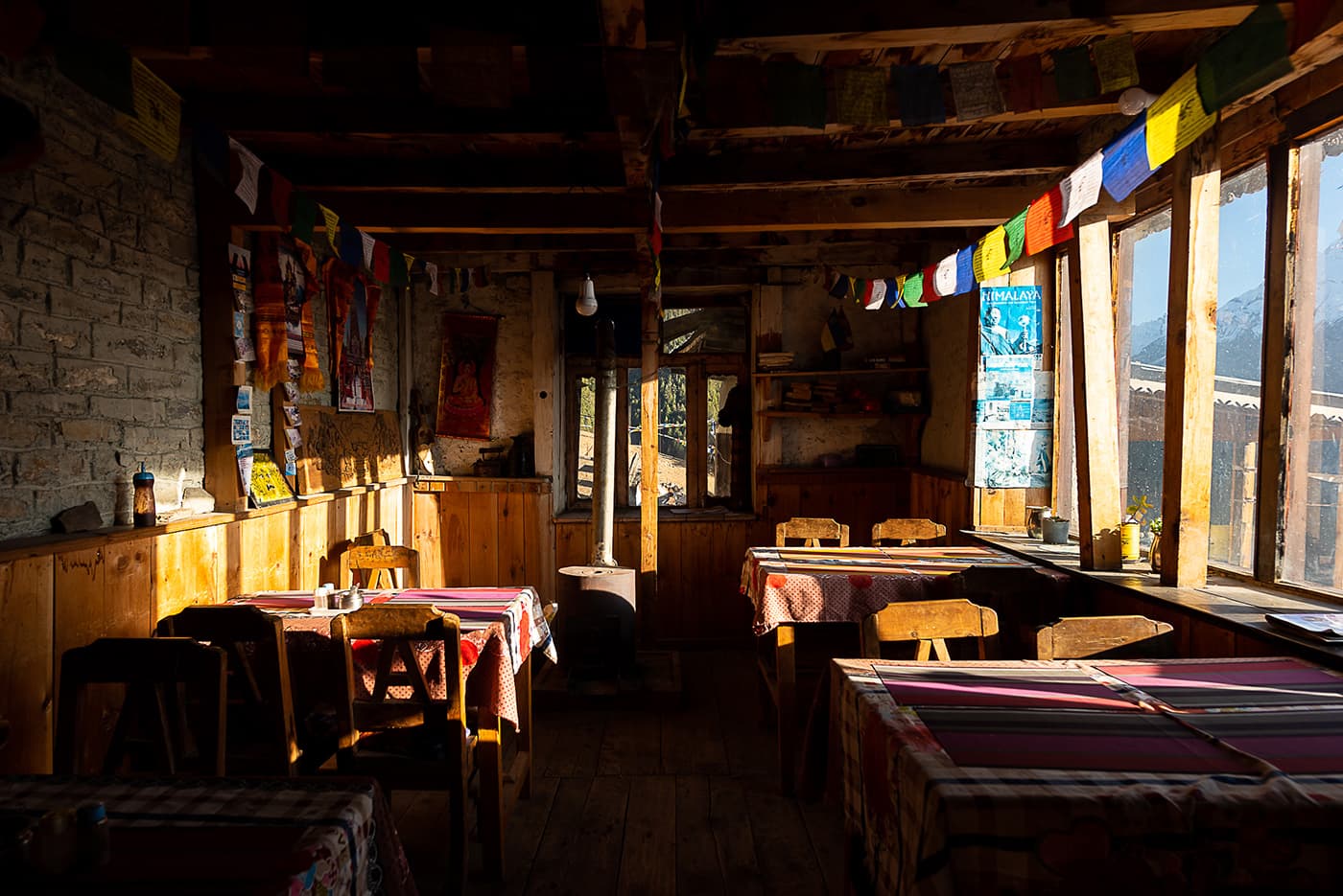
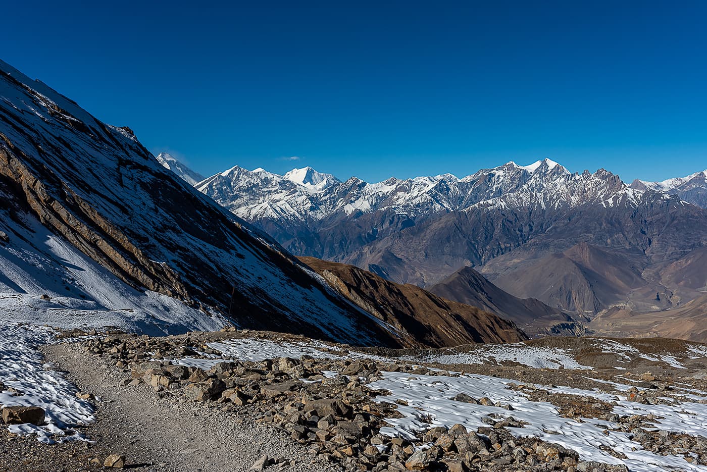
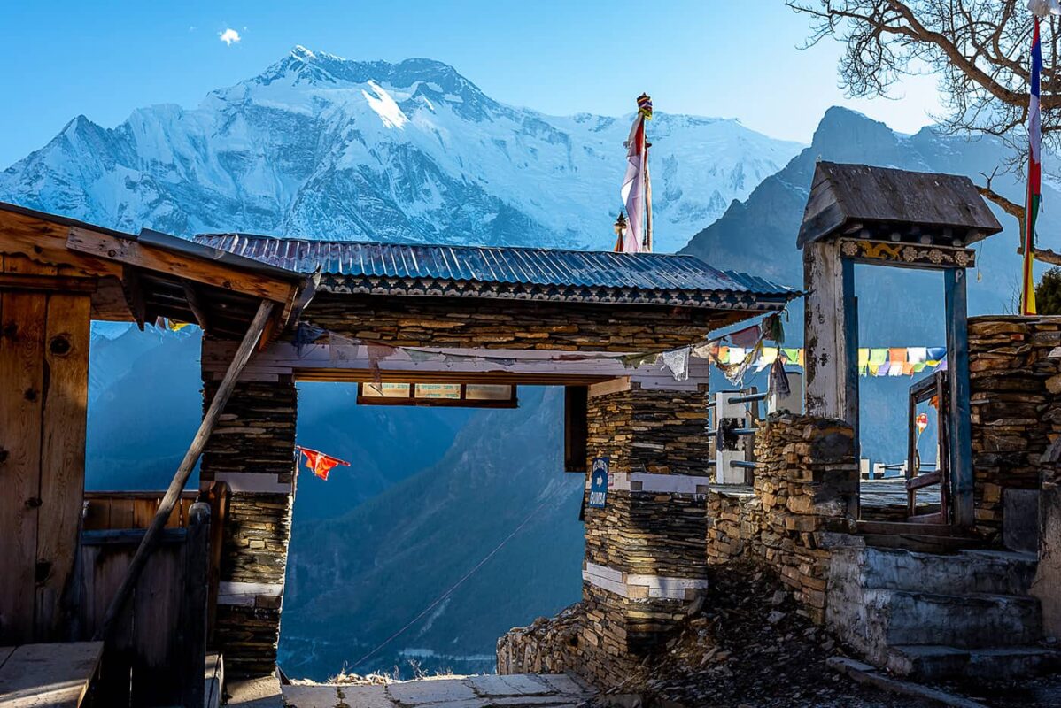
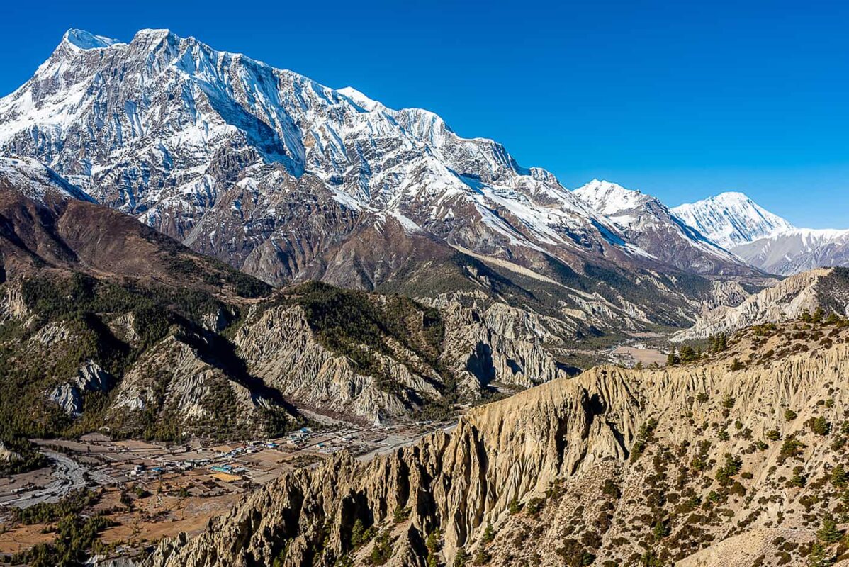
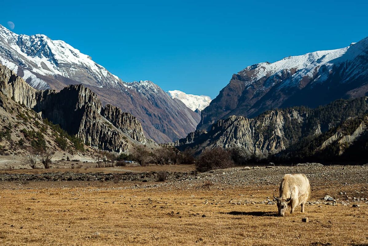
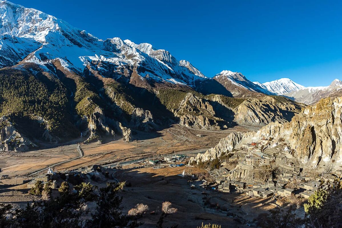
The starting point of the Annapurna Circuit can be in Besi Sahar, Jagat, or Dharapani, depending on where you ask your jeep or bus to drop you off. Wherever you start, first you will have to follow this dirt road for days until Manang. If you are in a rush or just interested in the higher mountains, you can drive a jeep up to Manang, do your acclimatization day, go through Larke Pass, and catch a bus on the other side, in four days. In the beginning, it’s not avoidable and your feet will be covered in dust for the first few kilometers. Some extra paths or older sections of the trail can cut the road and break the monotony, but sadly until Chame, you will follow this road. Despite this, the road is quite easy and not challenging, a good introduction, and an occasion to get your kicks before more difficult paths. Before Pisang, the scenery starts to get higher and the area slowly reveals itself at each corner you take. The road path becomes more “walkable” as traffic is even lower now, and you really sense now that you are on a higher and wider plateau, and you can quickly forget the dusty road as you are surrounded already by beautiful landscapes. You can sometimes see more developed areas, especially the apple orchard farms, which offer delicious cinnamon apple pies or fresh juices but most of the region is still very rural. Pisang is separated into two parts, Upper and Lower Pisang, both being in the shadow of the Annapurna II summit. Upper Pisang will be warmer, and it’s also the one further away from the dirt road, and it starts to hike on the older paths from now on, especially if you do a small but steep detour to Ghyaru, an incredible Tibetan stone village nested up a 400-meter high cliff above Pisang.

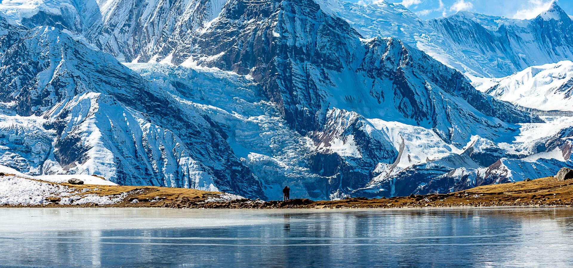
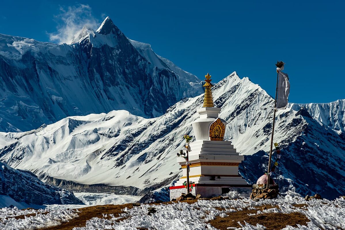
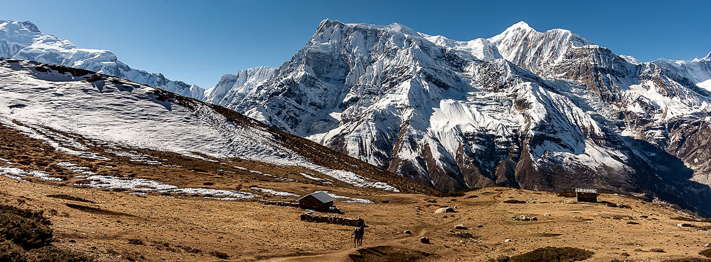
From the cliff you hiked up, you will keep being on a path far away and more elevated than the official jeep road, and the views start to be incredible until Braga or Manang. You can choose either village to base yourself there for the one day and two nights required for your acclimatization. The activities to do during your rest day are numerous, as you can hike up until Kicho Tal Lake (passed the Braga 500-year-old monastery built on the cliff behind the town, a must-see) which reaches 4635 meters high on a day hike, however quite challenging and requires an early (not later than 7 AM) start if you want to make it up and down in a comfortable day and avoid hiking down in the cold past 4 PM. You can also choose a two-day-one-night trip to Tilicho Lake, but it is known to be quite strenuous and can be challenging solo during some seasons, so caution is advised. Some trekkers also choose to hike to a cave/monastery pilgrimage in the region.

Once you have done two nights at this altitude, you should be okay altitude-wise and safe to carry further, however, be aware of Acute Mountain Sickness (AMS) and its symptoms (you can find more info later on, under the “Altitude” section).

The road ends at Manang on the main town square, and past the jeep parking, you should not see any more vehicles past this point, as well as not so many “villages” but more lodges or refuges for hikers and porters. From there, the trail is still well marked and maintained but is about two mules-wide. The path is not very challenging but lack of oxygen due to elevation can start to slow down most people starting at this point. You can choose to stop for the night either in Churi Ledar or further in Yak Kharka, depending on your pace and fitness, as both of them offer mountain lodges and refuges that often provide you with a warm fireplace and delicious food, but can be a bit less authentic than older houses down the valley. From there, past 4000 meters, the path and surrounding vistas get way more rugged and rocky, but still relatively easy, and for a while you will keep following the same canyon.

Midway through the path to base camp, you will cross the canyon river above a suspended bridge and can rest at a small teahouse right after. After tea, you will arrive in an area well known for landslides and rocks falling, and can be quite difficult and requires walking carefully due to a very narrow path sometimes. With a cliff drop down the canyon on your right side, and a steep hill on your left with rocks on the top only waiting to fall on you, it is a quite dangerous section, and accidents can happen especially during rainy seasons, but overall is quite safe during winter, as locals say. After that, you will reach Thorong Phedi, which consists of two base camps, one at 4400 (low camp) and the second one at 4800m (high camp). It is up to you and depending on your fitness/acclimatization level on where you want to sleep before Thorong la, but bear in mind that it’s better to climb up the steep and endless cliff between the two camps during the day, than early morning during your push for Thorong La Pass.

The Thorong La Pass sits at 5400 meters and requires a long 6 km uphill, although well marked and not very dangerous, it is advised to start very early in the morning, and if you are hiking solo, do not hesitate to join a group as any mistakes done in this area can become quickly dangerous. It is not very difficult, but challenging physically and even though no alpinism is required, past a certain point microspikes or crampons are strongly recommended and mountain hiking on the ice and snow is not to be underestimated. On the top, after a long walk up through ice and rocks, you will be welcomed by a small hut serving the most expensive but most rewarding hot tea in the region. You can sit in that tiny hut for a few minutes to warm up (temperatures can easily reach -20 degrees before sunsets on the snow) and wait until you have to go down. The first part of the descent can be quite tricky and still covered in ice, so tread carefully and stay following a group or around people.

The downhill is long but ice will quickly disappear, past a certain point, and the landscapes will change, offering different colors and tones as you now can look towards Muktinath, which borders sacred areas of Mustang. The town is a very famous pilgrimage in hindu culture, and even though pilgrims used to hike all the way up from Beni, they now all prefer the bus ride up and back. You can decide to join them from there back to Pokhara, or keep hiking down this beautiful region, going south towards Jomsom, Tadapani, etc …

Stages

The start of the Annapurna Circuit can be in Besi Sahar, Jagat, Dharapani, or even up until Manang, as recently a dirt road was built and now goes all the way up there and you can arrange a jeep to drop you until the road ends in Manang. From there you’ll trek until Muktinath, on the other side of the Thorong La mountain pass. After that, you can catch a jeep or bus from Muktinath to any town down the valley. I’ve added details for an extra section from Muktinath to Ghorepani, which used to be a part of the Circuit as well before most of it got replaced by a road, and it links with the start of the Annapurna Base camp trek if you are interested.

After stage 7, you can catch a bus back to Pokhara or if you want continue to hike down the road to the start of the Annapurna Base Camp trek (the “old circuit” way)

Annapurna Circuit 11 day itinerary

Stage 1:

Jagat or Dharapani – Chame, 15 km | 9.3 mi

Stage 2:

Chame – Ghyaru, 19 km | 11.8 mi

Stage 3:

Ghyaru – Braga or Manang, 12 km | 7.5 mi

Stage 4:

Acclimatization day (day hike to Kicho Tal Lake or two days round trip to Tilicho Lake possible (see details earlier)

Stage 5:

Manang – Churi Ledar or Yak Kharka, 12 km | 7.5 mi

Stage 6:

Churi Ledar – Thorong Phedi, 9 km | 5.6 mi

Stage 7:

Thorong Phedi – Muktinath via Thorong La Pass, 15 km | 9.3 mi

Stage 8:

Muktinath – Jomsom, 24 km | 15 mi

Stage 9:

Jomsom – Kalopani, 25 km | 15.5 mi

Stage 10:

Kalopani – Tatopani, 26 km | 16 mi

Stage 11:

Tatopani – Ghorepani (start of the Annapurna Base Camp trek), 18 km | 11.2 mi

Accommodations

On the Annapurna Circuit you can stay in traditional commercial tea houses, homestays owned by a family, hotels, or base camp settlements. Most of the rooms consist of two single-person beds, with a plug, a light, and a table. It is more comfortable than it seems and they are usually surprisingly clean. They all offer a thick blanket, but it is strongly advised to have a sleeping bag that can withstand cold temperatures at night. Some places can offer hot showers or buckets of hot water for daily hygiene. They provide cheap accommodation, which can be negotiable if you are in a lower season or end of the season. The maximum you’d pay would be 1000-1500 rupees per night.

Some guesthouses can decrease prices if you suggest that you eat dinner and breakfast in their home. Pro-tip is to spot the guesthouses that have a fireplace or an oven and try to avoid the first houses you encounter at the entrance of a village, as they tend to be more crowded, and those further down the village will welcome you more warmly with probably cheaper options and potential to negotiate. Locals are very friendly and they will not mind if you wander around a bit before finding the perfect teahouse for you. Some offer hot showers, or at worst a bucket of hot water, sometimes with a fee of a hundred or more rupees.

Best time of the year

Nepal has two main active seasons, each one between winter and the monsoon. The first most crowded and arguably the best time of the year to hike in the Himalayas is between September and December, and the second period ranges from April to May. The first tourist season tends to be described as the one having the most clear blue skies and the least rain with a dry atmosphere and progressively colder temperatures, but shorter days. The second period tends to be more humid, with remnants of the last winter but shows more attractive colors in the fauna as spring unveils beautiful flowers like rhododendrons and many others.

Outside of these periods, the trail might be either uncomfortably hot and humid in summer, or extremely cold and snowy in winter. Bear in mind that due to climate change effects in the region, over the past couple of years, the starting/ending dates tend to be more variable and each season tends to shift or linger, therefore predictions on the weather a few months/weeks prior might not follow usual trends anymore. As an example, I was still hiking in January 2023 in the Everest region, and according to locals, trails should have been covered in snow already.

Also, it has been reported that a few heavy monsoon rain showers tend to still happen up until late October, enough to create flooding of river beds or even landslides in many regions of the Himalayas. From personal experience, and maybe luck, the end of November / December seems to be the best weather-wise and with fewer crowds due to be considered “end of season”. Prices can also be a bit bargained with tourism agencies or tea houses regarding room prices, depending on the season and tourist affluence of the moment. For instance, in Annapurna, it is easier to get a free room if you stay eating dinner and breakfast in a lodge or discount a shower if you are in low season.

Remoteness

Peak time of the season can become very busy and can lead to overcrowded trails, but rare shortages of accommodation space from what I’ve heard. The Annapurna Circuit Trek is the second most popular trek after Everest Basecamp but attracts more solo travelers’ and fewer organized guide trips than in the Everest region. Expect large crowds at the mountain pass during the October-November season. The old man owning the tiny tea house at Thorong La Pass told me that during peak season, he can see up to 400 people crossing the pass in one day. On the other hand, in mid-December, we were around 30-40 in the high camp before crossing the pass.

Safety & Gear

Altitude

Altitude Sickness or Acute Mountain Sickness (AMS) is a medical consideration faced while trekking in the Himalayas and it is nothing to joke about. It rarely occurs at altitudes lower than 2,800m/9,186 ft., and only minor symptoms occur below 3,000m/9842ft. The sickness occurs when the body does not adjust well to the lack of oxygen at higher altitudes. The major cause of high altitude sickness is ascending to a height greater than 2,800m or 9000 ft. too rapidly. Giving the body little to no time to get used to the thinner air and lower oxygen levels triggers AMS. The primary signifier of altitude sickness is a persistent headache. However, if not addressed in due time, it may develop into more complicated variations such as high-altitude cerebral edema and high-altitude pulmonary edema. Medicine like Diamox can be taken to help prevent symptoms. However, they are to take into consideration that they are not a cure, just temporarily help your body to acclimatize, but do not take them if you are stranded at a high altitude with severe symptoms. The only medicine is to go down on altitude as quickly as you can, and nothing else. Taking paracetamol or anything else can even worsen the effects.

It is imperative to communicate your symptoms immediately to a person in your group, a guide of another group, or a staff from the tea houses who will know what to do. Many hikers each year get surprised and get into trouble once they reach 4000m. It is recommended to not go higher than 500m in elevation compared to the elevation of the last place you slept, as it is after 6 hours at high altitude that the “discreet” symptoms can occur in your body. Most hiking groups and guides will stop in Samagoan to have a rest day to acclimatize, however, they can advise not to if they see you fit and show no symptoms of altitude sickness, as was the case for me. There are many more detailed articles regarding AMS and its effect on the body, and it is always good to know what are the basic symptoms and how they affect the body before going to this region.  It is recommended if it’s your first time going that high recently, to stop and acclimatize for a day in Manang (or any other town in the range of altitude around 3500m)

Cold

Be mindful of the sun as you’ll hike counter-clockwise, around a massive mountain range of the Annapurna. It means the sun will set behind the whole mountain way quicker than usual, and temperatures can drop quite dramatically very fast starting from 3 PM. It is very good practice to start hiking quite early in the morning (leaving no later than 8 AM). Starting from 3000m, it is advisable to wear proper gear for the season and not underestimate the temperatures. For instance, when I slept at the base camp, temperatures in my room were negative and it is strongly recommended to bring a sleeping bag with you, even if most lodges provide thick blankets and often fire in the kitchen area. On Thorong La Pass, temperatures can drop to minus 20 degrees with strong wind, which can freeze your water. It is recommended to sleep with your water filter (as this shouldn’t freeze or it can damage the filter), your batteries, and a bottle of water inside your sleeping bag if you want to avoid them from freezing at night. In the mountain pass, a pair of good gloves was something I wished I had as I could feel my fingers getting numb very quickly.

Recommended gear

The Annapurna Circuit trail is not very rugged at the beginning as you will follow a large path on or next to the dirt road, then go progressively higher in more mountainous terrain. Although not extremely challenging, it is advised to have proper footwear, it is doable in trail runner shoes but make sure you have a stable and strong foot.

At the mountain pass, it is recommended and even mandatory by some agencies to wear crampons or at least spikes as the whole descent is on the ice. A pair of walking sticks can help to climb up, to find stability, and it helps alleviate the pain on your knees when you go down as well. Warm clothes for the evening as rare are the rooms heated. A sleeping bag for the night, even during the warmer seasons. A headlamp to walk on Thorong la Pass as most of the ascent will be before sunrise. A system to filtrate or purify your water. You can have a lightweight backpack as long as it fits a sleeping bag, warm clothes, water, and snacks.

All of the gear listed here can be found in all knock-off markets of Kathmandu or Pokhara. Some small gear can be replaced in some shops during the trial, but choice can be limited with higher prices. Not that they are necessary, but you can find in most bookshops of Kathmandu cheap paper maps of the region. You can pack some snacks from Kathmandu and Pokhara that will be cheaper, like nuts, snickers, biscuits, tea bags, coffee bags, honey, peanut butter, etc but the Annapurna has a nice supply chain and often you can find most of the snacks and drinks you can imagine in all the tea houses there.

Good to know

Permits

For the Annapurna Circuit you will need the Annapurna Conservation Area Project (ACAP Permit). This permit also grants you access to the Annapurna Circuit trek. It can be bought for 3000 NRP without the help of a tourist agency at the Tourist Service Centre and the Department of National Parks and Wildlife Conservation in Kathmandu, as well as The Annapurna Conservation Area Project (ACAP) office in Pokhara. It will not be difficult to obtain and every guesthouse in Kathmandu will be able to direct you. They can also be bought on the spot when you enter the national park, but it’s more expensive. Be prepared to have 2 passport pictures when you apply for each permit (if you require more permits later, you will also need to bring more pictures, and they are more expensive to be made on the spot).

It used to be recommended to also get a TIMS card (hiker’s ID) in Kathmandu, but it’s now rarely recommended nowadays as even tourist agencies will advise you not to waste your money on it, and during my 46 days in the Himalayas, nobody ever asked me to show it. However, tourism laws and politics can change quickly each season, so always double-check this information with your agency or official sources.  This permit is to be kept with you at all times, and to be able to show them to control checkpoints. There are checkpoints in Dharapani, Chame, and Manang and you’ll be required to show your permits and papers so keep them with you. This permit also grants you access to the Annapurna Base Camp trek.

You can organize your trip solo (at the time of speaking, please check regulations and if guides are required) or go through a tourist agency in Kathmandu or Pokhara, which will provide you with a package Guide (not mandatory at the time of speaking) + porter (optional) + permits + transports. A guide costs roughly 25 USD/day (that is fixed for up to 6-8 persons) and also expects a baksheesh (tip) at the end of the trip.

Permit costs Annapurna Circuit
Annapurna Conservation Area Project (ACAP Permit) 30 USD

Water and food

Every village I passed had a water fountain and water was widely available, but that can change a little bit depending on the seasons. It’s well recommended to have your own filtration or purification system to avoid buying plastic bottles of water and possible water contamination. Water in the area (taps and fountains) is from the mountain and unfiltered. I used a filter like Platypus, but chlorine tabs work well, are cheap, and are widely available in Kathmandu’s pharmacies. Always take water from moving water as lakes in the areas are heavily sedimented and can clog filters faster.

Food in teahouses is usually very good, but the price increases proportionally to the altitude. I strongly recommend trying local food, like the famous dal bhat (rice and lentil curry) which provides everything you need for a full day of hiking or to recover from it, and locals will swear by it as they eat it every day. Every guesthouse has its own recipe, which can vary from passable taste to the most exquisite flavors. You can also try momos (stuffed dumplings, steamed or fried), and many other Tibetan or Indian-influenced dishes, to combine with a masala chai tea. If you can find a place that makes Snickers-roll, you have to try it (after you finish your hike). The guesthouses are very resourceful and menus can be surprisingly varied and intricate so feel free to try anything, even yak burgers or some pizzas aren’t that bad either.

Local wildlife

You will see quite a few mules and later in higher elevations, they will be replaced by yaks and massive herds can be seen around Manang or Yak Kharka (Yak meadows in Nepali). It is a good practice to always position yourself the furthest away from the cliff when passing or crossing a beast of burden. As they are loaded “on their side” with gas canisters, rice bags, and more, they are not aware of their real width and can push people towards cliffs when they walk next to them. You will see quite a few eagles and birds of prey and can hear marmots whistling sometimes.

Tourist Agencies

Many tourist agencies in Kathmandu or Pokhara offer packages (jeep + guide + porter + anything else) and do not hesitate to ask to personalize what you want. It is not necessary to have a porter unless you have a large group or a family for example. Many agencies offer tours that are similar and prices can always be haggled, especially if you are in a lower season period or in a bigger group. It is mandatory to have a guide with you in this area. Also, keep in mind anything tour or trip bought online before arrival in Nepal will be double or triple the price of any tour you can get here.

Route
Point to point
Highest point
5400m (17716 ft)

Guidebooks

cover guidebook

Trekking in the Himalaya

View guidebook

Want to submit a trail or make this page more complete?

Comments

Be the first one to comment on this trail!

Reply to this trail

Your email address will not be published. Required fields are marked *

Reply to this trail

Log in to comment on this trail
Always read the disclaimer

Terms of Use: important to all visitors on this website. We strive to publish high quality content and information on this website. However it’s always possible that we’re missing out on some crucial information. In spite of the fact that this route, associated GPS track (GPX and maps) were prepared under diligent research by the specified contributor and/or contributors, the accuracy of such and judgement of the author is not guaranteed. Therefore, hiking-trails.com and contributors are in no way liable for personal injury, damage to personal property, or any other such situation that might happen to individuals hiking or following this route. Should you choose to hike this trail, this is always at your own risk. Check out our guidelines for safety hiking and Leave No Trace principles at the hiking 101 page.

Download GPX

Join the community!

Login or create a FREE account 😊

With an account you can:

Download GPX files

Pin trails to your wishlist

Mark trails as hiked by you

Rate hiking trails

Comment on trails, blogs and gear reviews

Happy trails!
Login

Don't have an account yet? Register here