logo tour du mont blanc trail

About the Tour du Mont Blanc

Alps
country
France, Italy, Switzerland
length
165 km(103 mi)
Type of trail
Long-distance, Hut to hut
difficulty

Difficulty is highly personal. Be aware of the weather conditions as bad weather turns easier trails in difficult trails especially in the mountains.

Difficult
accommodation

Lodging means a mix of hotels, hostels or AirBnB’s.

Mountain huts, Camping, Lodging
Elevation gain
10000 m(32808 ft)
terrain
Mountains
remoteness
Some of the time
Show more

The world-famous Tour du Mont Blanc (TMB) is Europe’s most popular long-distance mountain hike, and for good reason. This epic route, circling the Mont Blanc massif in the Alps, lives up to its reputation as a classic. It’s a great choice for hikers who want to try a longer trek for the first time. The 165km loop is usually split into 11 stages, taking you through France, Italy, and Switzerland. The official starting point is Les Houches in France, but you can pick any town on the route as your starting point.

Of course, popularity means crowds: 10,000 hikers each year, to be precise. People travel from all over the world to walk the Tour du Mont Blanc. If you’re hiking this as a hut-to-hut trek, sleeping in the refuges, you’ll need to pre-book some months in advance.

profile picture Lisa Butler
Author

Lisa Butler

Lisa Butler has been obsessively hiking long-distance trails for more than ten years. She’s covered more than 7,000km all over the world. She prefers to hike solo to give her a deeper connection to nature and encourages as many women as possible to hike and wild camp solo too. You can follow Lisa on Instagram @thruhikes.

View profile

The Trail

It’s possible to avoid the crowds on the Tour du Mont Blanc by hiking the variants. These lesser-walked epic sections are the most magnificent stages of the whole TMB but are tougher than the main trail, so are only for experienced hikers.

The TMB’s route is varied, passing through inhabited valleys, stunning forests, and high mountain passes. Throughout, there are views of the Mont Blanc massif’s glaciers, which are sadly receding at an alarming rate.

Most people will travel to Chamonix in the French Alps to begin the TMB. You’ll find everything you could possibly need for your hike in this town of mountain lovers. The official starting point is the village of Les Houches, 7km away from Chamonix in the Vallée de l’Arve. You can walk clockwise or anti-clockwise, with anti-clockwise being the preferred choice for most people.

Walking anti-clockwise from Les Houches, there are two possible routes to hike stage 1 to Les Contamines-Montjoie. One is shorter and is preferred in bad weather. The other option is more epic, crossing a suspension bridge, passing the Bionnassay glacier, and taking you up over the Col de Tricot (2120m).

Stage 2 is tough for anyone who is still finding their fitness on the trail, crossing two high passes – the Col du Bonhomme (2329m) and the Col de la Croix du Bonhomme (2483m). From the second col, hikers can choose whether they leave the crowds to walk the variant route. The variant takes you over another pass, the Col des Fours (2665m).

You’ll cross from France into Italy on the easier stage 3 at the Col de la Seigne (2516m), and continue through Italy on stage 4 to the scenic hikers’ town of Courmayeur – a good place to take a rest day if needed. Stage 5 takes you up through the forest where you can choose between the main route and the high variant on the Mont de la Saxe ridge, with spectacular views of the south face of the Mont Blanc range.

You’ll cross over the Grand Col Ferret (2537m) into Switzerland on stage 6. From here you’ll leave the dramatic glaciers behind, at least for now. The trail descends into the Swiss Val Ferret, where Switzerland lives up to its stereotypical reputation, with cows with bells around their necks, green meadows, wildflowers, and beautiful forests.

Stage 7 to Champex is the easiest stage of the TMB, passing pastures. Stage 8 gives you the option of taking the Swiss variant, the Fenêtre d’Arpette (2665m), the most spectacular – and toughest – section of the whole TMB. The Fenêtre is a steep scramble up then down and takes you so close to the Trient glacier that you can almost touch it.

Stage 9 takes you back into France, over the Col de Balme (2191m). There’s the option of yet another variant to the Col, perfect if you’re craving being away from people. Mont Blanc reappears, as does Chamonix, far down in the valley below.

You’ll hike back through the higher slopes of the Vallée de l’Arve on the final stages, 10 and 11, and into the Réserve Naturelle des Aiguilles Rouges. There are a series of metal ladders, adding some excitement to the final sections! Many hikers take the route to Lac Blanc, a stunning, clear lake, popular with day hikers, with some of the best views of the trail. Finally, you’ll find yourself back in Les Houches, where you began.

Stages

Suggested 8-day camping itinerary for fit and independent hikers

Stage 1: Les Houches – Nant Borrant (bivouac), 23km | 14.3 mi, 9h

Stage 2: Nant Borrant – approach to Col de la Seigne (bivouac), 21 km | 13 mi, 8h

Stage 3: Col de la Seigne – Courmayeur (hotel), 19km | 12 mi, 7,5h

Stage 4: Courmayeur – La Peule (ask for permission near refuge, for fee), 26km | 16 mi, 10h

Stage 5: La Peule – Champex (campsite, for fee), 20km | 12.5 mi, 7h

Stage 6: Champex – Le Peuty (near refuge, for fee), 16km | 10 mi, 6h

Stage 7: Le Peuty – Lac des Chéserys (bivouac), 19km | 12 mi, 7h

Stage 8: Lac des Chéserys – les Houches, 21km | 13 mi, 8h

The classic itinerary (anti-clockwise: 11 days)

Stage 1:

Les Houches – Les Contamines, 17.5 km | 10.9 mi

Stage 2:

Les Contamines – Les Chapieux, 19 km (or 20km, variant to Refuge des Mottets) | 12 mi

Stage 3:

Les Chapieux – Rifugio Elisabetta, 14 km | 8.7 mi

Stage 4:

Refugio Elisabetta – Courmayeur, 15,5 km (or 19.5km via Rifugio Monte Bianco) | 9.6 mi

Stage 5:

Courmayeur – Rifugio Bonatti, 12 km (or 16km via the Mont de la Saxe variant) | 7.5 mi

Stage 6:

Rifugio Bonatti – La Fouly, 20 km | 12.5 mi

Stage 7:

La Fouly – Champex, 15.5 km | 9.6 mi

Stage 8:

Champex – Trient, 16 km (or 16km via the Fenêtre d’Arpette variant) | 10 mi

Stage 9:

Trient – Tré-le-Champ, 14 km| 8.7 mi

Stage 10:

Tré-le-Champ – La Flégère, 8 km (or 9km, 3.5hr via Col des Montets variant) | 5 mi

Stage 11:

La Flégère – Les Houches, 18.5 km | 11.5 mi

Accommodations

The Tour du Mont Blanc is a classic hut-to-hut hike. You must book your accommodation months in advance: this is a very busy trail. Luckily, there are many options to accommodate so many hikers.

The TMB is not cheap if you hike it as a hut-to-hut trek. You’ll stay in the high-quality refuges scattered high up in the mountains, or in the hotels, gites d’etape, and auberges in the valleys. Expect to pay a half-pension rate (dorm bed, dinner, and breakfast) of roughly 50-60 euros per night. Many people book their accommodation through tour agencies, but you can also do it yourself using the TMB’s online booking.

Camping on the Tour du Mont Blanc

Camping does, of course, make the TMB much cheaper. Camping gives you more freedom to walk later into the evening when the trail is completely empty. These moments of peace will likely be some of the most special times of the hike.

Legally you can only wild camp in the French section. France provides campers with free Aire de Bivouac spots, and under the country’s regulations, bivouacking (setting up a tent late and taking it down early, using Leave no Trace principles) is legal. Switzerland, on the other hand, is strict about wild campers on the TMB. Although wild camping is certainly possible, you risk getting caught and fined. It is also illegal to wild camp on the Italian section, although realistically, hikers rarely find problems if they set up late and take down at sunrise.

The variants give the hiker more freedom to have the mountains to yourself, where you will likely be the only person sleeping under the stars.
There are a number of official campsites in the towns that you’ll pass through on the trail, particularly handy if you’re worried about being fined for wild camping in the Switzerland section.

Overnights in the mountain huts / accommodations

There are many huts and hotels to choose from on the Tour du Mont Blanc. Huts are scattered high up in the mountains, sometimes halfway through a section. This means you really have the freedom to make your own itinerary, giving you the choice to sleep up in the mountains, avoiding spending the night in villages. You can find the full list of accommodations on the TMB here.

All accommodation can provide hikers with meals and drinks, even if you’re not staying there. Expect high-quality homemade pasta in the Italian rifugios – a highlight of walking the TMB!

Accommodation for the classic 11-day itinerary

Stage 1:

Les Contamines – a range of accommodation in town

Stage 2:

Les Chapieux – Auberge de la Nova

Stage 3:

Rifugio Elisabetta

Stage 4:

Courmayeur – large range of hotels in town

Stage 5:

Rifugio Bonatti

Stage 6:

La Fouly – a range of accommodation in town

Stage 7:

Champex – a range of accommodation in town

Stage 8:

Trient – Auberge Mont Blanc

Stage 9:

Tré-le-Champ – Auberge la Boerne

Stage 10:

La Flégère – Refuge La Flégère

Stage 11:

Les Houches – a range of accommodation. Most hikers will stay in Chamonix, 7km up the road.

Best time of the year

The best time of the year to hike the Tour du Mont Blanc are July, August, and the first two weeks of September. Before July, you are likely to find snow on the passes. And if you want to hike at the end of September or the beginning of October, you may find that you’re caught in the first snows of the season.

Like any mountain hike, thunderstorms are a real risk on the TMB and usually roll in in the afternoon. Keep an eye on the weather forecast – after all, you don’t want to be caught on a mountain pass, or on a ridge, when there’s lightning.

Safety & Gear

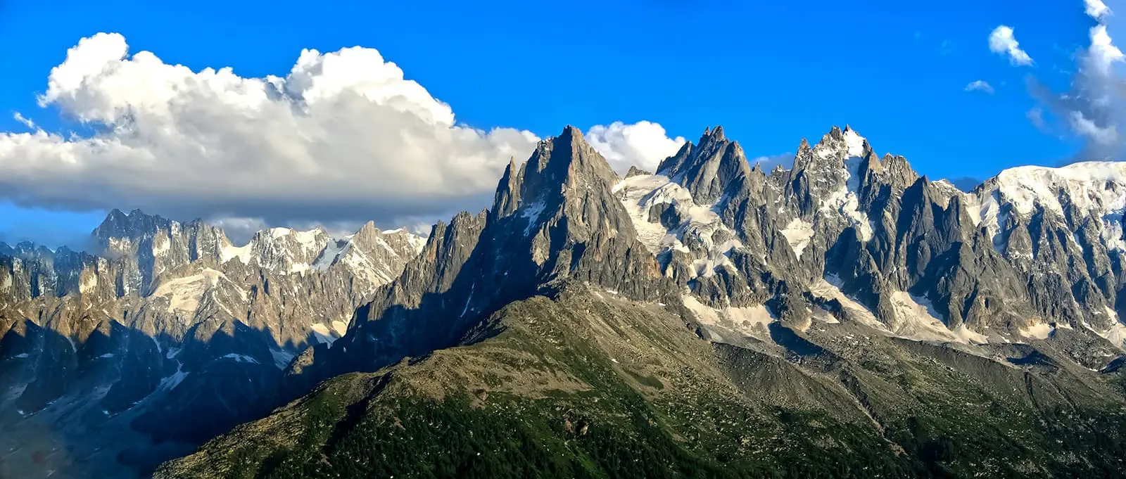
The TMB is popular, but you shouldn’t underestimate how tough it is. Although it isn’t technical (other than on the Fenêtre d’Arpette variant), its steepness makes this trail a challenge for even the fittest hiker. If this is your first long-distance hike, it makes sense to train before you leave home to increase your fitness levels and stamina.

Stage 10 involves climbing ladders, which could be terrifying for those with a fear of heights. There are alternative, easier routes if you want to avoid the ladder section. If you’re hiking with a dog (perfectly possible if you are camping), you will also have to take a detour on stage 10 – not just because of the ladders, but because dogs are not permitted in the Réserve Naturelle des Aiguilles Rouges. This is the only detour you’ll have to take if hiking with a dog.

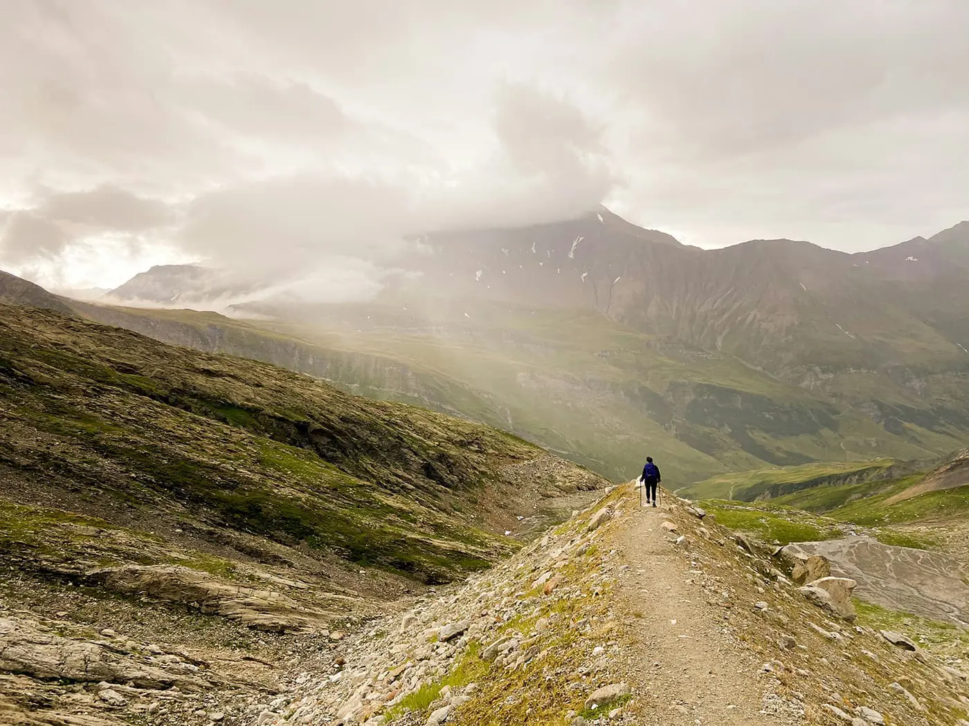
The TMB is, of course, busy, so if you get into trouble, there will likely be someone close at hand to help you. But if you’re hiking the high-level variants, it is essential that you find out about trail conditions just before you hike. On these variants, you might see no other hikers for some hours. Try to tell someone off-trail of your chosen route if hiking the variants.

Remember that thunderstorms can develop in the afternoons: keep an eye on the forecast and don’t get caught in a lightning storm high up on a mountain pass.

Stay hydrated! Water is abundant on the trail — you can fill up at any of the huts and guesthouses you pass. Carry at least 2 liters with you. Food, too, is available at all accommodations, but make sure you carry snacks.

It is almost impossible to get lost on the TMB. But it is sensible to carry a paper map and compass – if you don’t know how to navigate with these tools, learn before you leave home. Make sure you download offline maps onto your smartphone: mapy.cz is the map app of choice for hikers right now. It has the TMB marked in red on the app, so there’s no need to download a separate gpx file. If you’re primarily dependent on your phone to navigate, carry a power bank too. You don’t want to be caught with no battery life on the mountain.

Pack the right gear! Waterproofs are essential, as are warm baselayers. Hiking poles are advisable: after all, the elevation gain on this tail is around 10,000m, and there are steep descents. Poles will be essential for anyone with weak knees. If you buy new hiking shoes for this trail, make sure you break them in before leaving home to avoid blisters on the trail.

Respect the principles of Leave No Trace by minimizing your impact on the environment. Stick to designated trails, pack out all trash – including toilet paper – and respect wildlife and natural habitats.

The TMB website has good information about mountain safety and what to do in an emergency. Read up before getting on the trail.

Good to know

The Tour du Mont Blanc is a busy trail, but the TMB is so stunning that hopefully, the crowds won’t ruin your experience. It is essential to book your accommodation a few months in advance (see the accommodation section above). If you like empty trails, this isn’t the hike for you.

Route
Circuit
Highest point
2665m (8743 ft) on the Fenêtre d’Arpette variant

Guidebooks

guidebook tour du mont blanc

Tour du Mont Blanc

View guidebook

Want to submit a trail or make this page more complete?

Comments

Be the first one to comment on this trail!

Reply to this trail

Your email address will not be published. Required fields are marked *

Reply to this trail

Log in to comment on this trail
Always read the disclaimer

Terms of Use: important to all visitors on this website. We strive to publish high quality content and information on this website. However it’s always possible that we’re missing out on some crucial information. In spite of the fact that this route, associated GPS track (GPX and maps) were prepared under diligent research by the specified contributor and/or contributors, the accuracy of such and judgement of the author is not guaranteed. Therefore, hiking-trails.com and contributors are in no way liable for personal injury, damage to personal property, or any other such situation that might happen to individuals hiking or following this route. Should you choose to hike this trail, this is always at your own risk. Check out our guidelines for safety hiking and Leave No Trace principles at the hiking 101 page.

Download GPX

Join the community!

Login or create a FREE account 😊

With an account you can:

Download GPX files

Pin trails to your wishlist

Mark trails as hiked by you

Rate hiking trails

Comment on trails, blogs and gear reviews

Happy trails!
Login

Don't have an account yet? Register here