About the Hadrian’s Wall Path

country
England
length
135 km(84 mi)
Type of trail
Long-distance, Thru-hike
difficulty

Difficulty is highly personal. Be aware of the weather conditions as bad weather turns easier trails in difficult trails especially in the mountains.

Moderate
accommodation

Lodging means a mix of hotels, hostels or AirBnB’s.

Camping, Lodging
Elevation gain
1800 m(5906 ft)
terrain
Hills, Countryside
remoteness
Some of the time
Show more

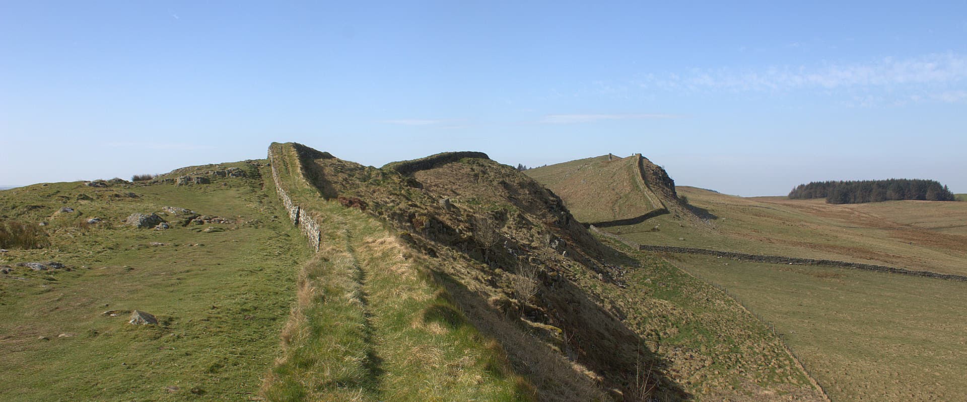
Hadrian’s Wall Path is a long-distance trail across northern England, stretching from Wallsend near Newcastle upon Tyne to Bowness-on-Solway. Over 135 kilometers, you hike from the River Tyne to the Solway Firth, passing Roman forts, green countryside, small villages and the remains of Hadrian’s Wall. Construction of the wall began in AD 122 on the orders of Emperor Hadrian to protect the north-west frontier of the Roman Empire. Almost 2,000 years later, you can follow its history on foot.

The trail is one of England’s National Trails and is a good option if you’re looking for your first long-distance hike. There are B&Bs, small hotels and campsites along the way, so you can choose between carrying your tent or finishing each day with a proper bed. Give yourself around a week to enjoy the hiking and leave some time for the Roman sites. There’s quite a lot to stop for.

Elmar profile picture
Editor

Elmar Teegelbeckers

Passionate hiker Elmar spends months of his time on the trail. He’s usually on the lookout for hidden gems in one of his favourite countries such as Slovenia, Switzerland and Japan. He founded hiking-trails.com in need for a community and detailed information about the trails. Before this, he worked for the Alpine asscociation in the Netherlands[ (NKBV) but lost his heart to the trails.

Not long ago, Elmar published the book (in Dutch) Hiking Trails – best long-distance trails in Europe. With this book, website and socials, he hopes to inspire and shape an inclusive community for hikers all over world. No matter your speed, experience or level, you can get out there to enjoy the trails and connect with the heartwarming hiking community. Life is so much better outside and he hopes to inspire hikers to take their first, or next, step on the trail.

You can reach Elmar at info@hiking-trails.com.

View profile

The Trail

You can hike Hadrian’s Wall Path in either direction. This description follows the trail from east to west, starting at Segedunum Roman Fort in Wallsend and finishing in Bowness-on-Solway. It takes you through Newcastle first, with the hillier sections waiting in the middle of the trail.

The first day follows the River Tyne through Newcastle. Expect riverside paths, bridges and quite a bit of pavement before the surroundings become greener towards Newburn. It’s a different start from the open hills you might associate with Hadrian’s Wall, but a nice way to see the city on foot. The day ends with a climb towards Heddon-on-the-Wall.

From Heddon, the trail heads into farmland, following field edges and sections beside the Military Road. Here, the Roman frontier is sometimes easier to recognise in the shape of the ground than in standing stonework. You finish in Chollerford, beside the River North Tyne.

Beyond Chollerford, the landscape becomes more open and the climbs begin. This is where you reach the central section of the trail, with long stretches of wall running across the hills. Allow time for Housesteads Roman Fort if you want to take a closer look at Roman life along the frontier. The remains include barracks, headquarters and buildings that once served a garrison of around 800 soldiers.

Around Housesteads, Crag Lough and Steel Rigg, the wall follows the rocky Whin Sill escarpment. The path goes up and down with it, so don’t expect a quick day just because the distance looks manageable. There are plenty of places where you’ll want to stop, sit down and look back at the wall crossing the hills behind you.

Once Brewed makes a useful overnight stop near this section. From here, you continue west over the crags before the landscape gradually softens towards Gilsland. The wall, ruined milecastles and open views give you plenty to look at along the way.

After Gilsland, the route passes Birdoswald Roman Fort and continues towards the quieter countryside around Banks and Walton. The steepest hills are behind you now. The following stretch into Carlisle takes you through farmland and small settlements, with a change of pace when you reach the city.

The final day takes you towards the Solway Firth. Fields give way to a flatter, more open landscape, with salt marshes and wide skies as you approach Bowness-on-Solway. It’s a quiet finish after the busier paths around the central wall. Before setting out, check the tide advice for the section around Burgh Marsh, where high tides can affect the route.

Stages

Hadrian’s Wall Path can be hiked in around six to eight days. The seven-day itinerary below keeps the central sections shorter, leaving more time for the wall and Roman sites. Distances are approximate, and walks to your accommodation can add a few extra kilometers.

These are suggested overnight stops rather than fixed stages. Plan your accommodation first, then check the daily distances against your chosen route and any detours.

Hadrian's Wall Path 7-stage itinerary

Stage 1:

Wallsend – Heddon-on-the-Wall, 24 km | 15 miles

Stage 2:

Heddon-on-the-Wall – Chollerford, 24 km | 15 miles

Stage 3:

Chollerford – Once Brewed, 21 km | 13 miles

Stage 4:

Once Brewed – Gilsland, 14.5 km | 9 miles

Stage 5:

Gilsland – Walton, 11 km | 7 miles

Stage 6:

Walton – Carlisle, 19.5 km | 12 miles

Stage 7:

Carlisle – Bowness-on-Solway, 22.5 km | 14 miles

Accommodations

You can hike Hadrian’s Wall Path from B&B to B&B, stay in small hotels and inns, or bring your tent and use campsites. Sleeping indoors makes it possible to travel with a lighter backpack, and baggage transfers are available if you prefer to carry only what you need for the day.

Book ahead, particularly if you want to stay close to the trail. Check the location carefully before reserving: accommodation advertised for Hadrian’s Wall walkers may involve an extra walk or a transfer. It’s also worth checking dinner arrangements at the same time, especially when you’re staying outside a village.

For camping, plan around established campsites and check how far they are from the path. Don’t assume you can pitch beside the wall. Arrange permission with the landowner for any stay outside a campsite.

Best time of the year

The best time to hike Hadrian’s Wall Path is between May and October. Walking during the drier months also helps protect the buried archaeology beneath the path, which is more vulnerable to damage when the ground is wet.

May, June and September are good months to consider when planning your hike. Summer gives you long days for walking and visiting the forts, while autumn brings shorter daylight hours. Whenever you go, pack for rain and wind. A dry forecast is welcome, but it shouldn’t decide whether your rain jacket comes along.

Safety & Gear

Take care on the central crags, particularly when the stones and grass are wet. Before the final stage, check tide information and local advice for Burgh Marsh. If the route is flooded, wait or follow an advised alternative.

The trail is marked with the National Trail acorn symbol, but download an offline map or GPX as well. Keep a charged phone, power bank and small first aid kit in your backpack.

Carry lunch and snacks rather than depending on finding an open café along the way. Check where you can refill drinking water before leaving your accommodation each morning.

Essential gear

If you’re staying in B&Bs, you can keep your packing fairly simple. Bring comfortable hiking footwear, waterproofs, warm layers and enough food and water for each stage. Test your shoes on longer walks beforehand, as several days of walking can reveal problems you won’t notice on a short afternoon hike.

If you’re camping, bring a tent and sleeping equipment suitable for wet and windy conditions, and plan your overnight stops before setting out.

Difficulty

Hadrian’s Wall Path is a moderately difficult trail. Much of the walking is straightforward, but the central section has repeated steep climbs and descents. The highest point is only 345 meters, although the short hills can make a day feel considerably harder than the distance suggests.

For a first long-distance hike, give yourself enough days and get used to walking with your backpack before setting out. Shorter stages also leave time to visit the forts without having to hurry through the rest of your day.

Good to know

Hadrian’s Wall Path follows the Roman frontier, but you won’t see a standing wall for the full 135 kilometers. Some stretches have substantial remains, while elsewhere the wall has disappeared or survives as earthworks. The changing landscape is part of the walk, from Newcastle’s riverside to the crags of Northumberland and the Solway coast.

Allow extra time if you want to visit the Roman sites. Following the trail and exploring a fort are two different things, and a visit can easily become a large part of your day.

Stay on the marked path and follow signs around the archaeological remains. The wall and the ground around it are fragile, so avoid climbing on the stonework and help keep the route in good condition for the hikers who come after you.

route
point-to-point
highest point
345 m (1,132 ft), Winshields Crags

Want to submit a trail or make this page more complete?

Always read the disclaimer

Terms of Use: important to all visitors on this website. We strive to publish high quality content and information on this website. However it’s always possible that we’re missing out on some crucial information. In spite of the fact that this route, associated GPS track (GPX and maps) were prepared under diligent research by the specified contributor and/or contributors, the accuracy of such and judgement of the author is not guaranteed. Therefore, hiking-trails.com and contributors are in no way liable for personal injury, damage to personal property, or any other such situation that might happen to individuals hiking or following this route. Should you choose to hike this trail, this is always at your own risk. Check out our guidelines for safety hiking and Leave No Trace principles at the hiking 101 page.

Download GPX

Join the community!

Login or create a FREE account 😊

With an account you can:

Download GPX files

Pin trails to your wishlist

Mark trails as hiked by you

Rate hiking trails

Comment on trails, blogs and gear reviews

Happy trails!
Login

Don't have an account yet? Register here