Granite walls lean over a valley on the Akshayuk pass hiking trail

Akshayuk Pass

Nunavut/Baffin Island

About the Akshayuk Pass

country
Canada
length
97 km(60 mi)
Type of trail
Long-distance
difficulty

Difficulty is highly personal. Be aware of the weather conditions as bad weather turns easier trails in difficult trails especially in the mountains.

Strenuous
accommodation

Lodging means a mix of hotels, hostels or AirBnB’s.

Wild camping
Elevation gain
970 m(3182 ft)
terrain
Mountains
remoteness
All the time
Show more

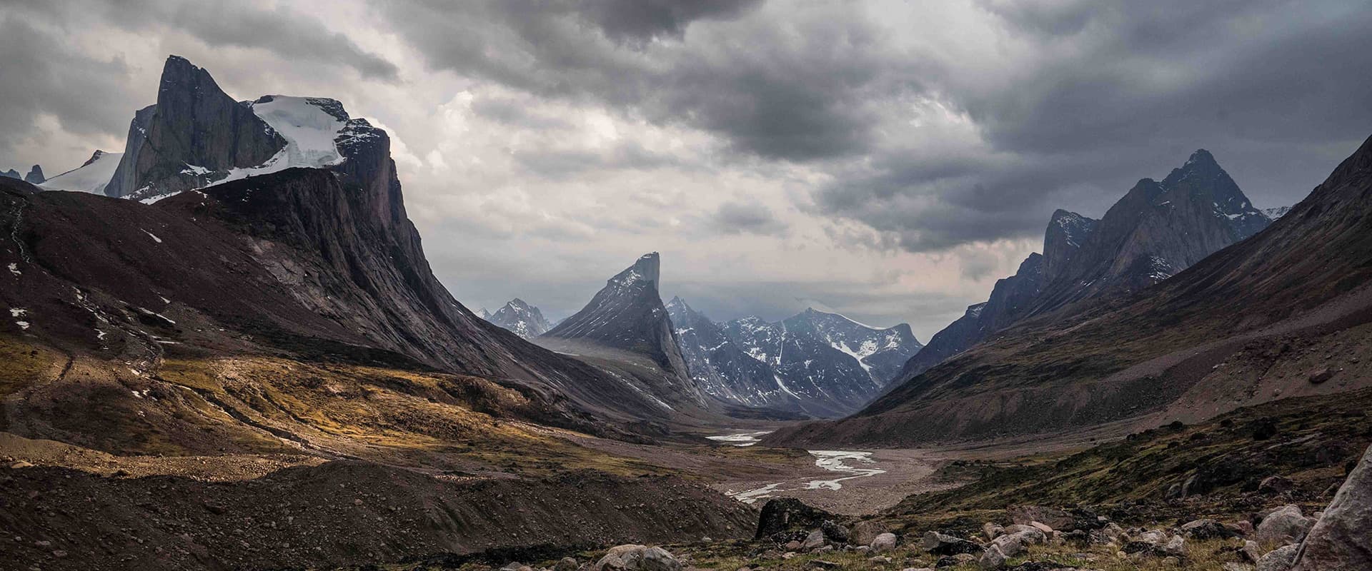
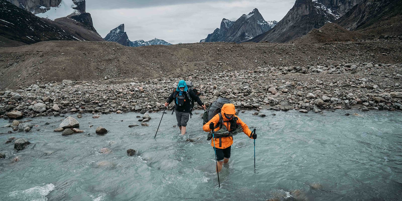
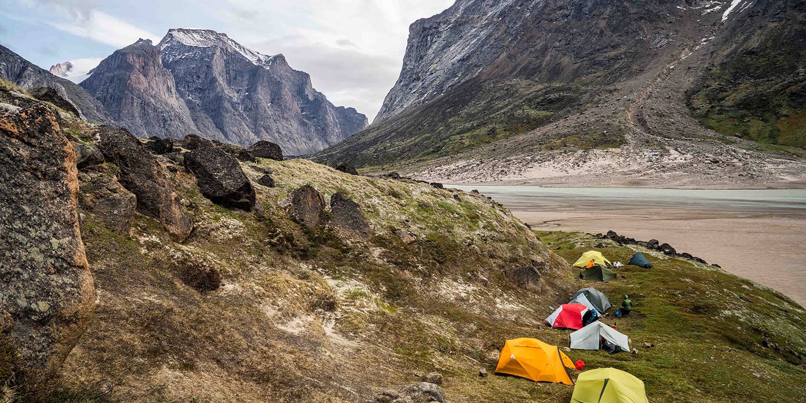
The Akshayuk Pass, cutting straight through Auyuittuq National Park on Baffin Island, is one of the most epic & stunning Arctic corridors with views over some of the planet’s tallest walls. Granite walls lean over a valley, ancient ice fields spill over into rivers, and the silence is so complete you can (almost) hear the mountains breathe. But there’s more to this route than its raw beauty!

On the trail, you’ll walk through a living textbook of Arctic geography. Once buried under massive ice sheets, the valley now has moraines, polished rock, and floodplains shaped & carved over thousands of years. This trail is very strenuous and only for hikers who have a lot of experience with remote, challenging trekking.

Monica & Albert from Amarok adventures

Monica & Albert from Amarok Adventures

Albert and Monica are licensed AIMG guides and Senior Polar Guides by PTGA, combining their passions for the outdoors, the polar regions, and high mountains. With backgrounds rooted in exploration (Albert behind the camera, capturing the raw essence of each journey, and Mónica driven by a lifelong love for climbing, skiing, and wild terrain), they’ve built a life around sharing remote, meaningful adventures with others. Together they run Amarok Adventures, designing and guiding the kind of expeditions they’d choose for themselves: authentic, challenging, and deeply connected to the landscapes they love. You can follow them on Instagram @amarokadventures.

View profile

The Trail

The Pass is roughly 97 kilometers from the northern coast at Qikiqtarjuaq down to the Pangnirtung Fjord. Over the course of nearly two weeks, you’ll hike through valleys, over riverbeds, and along the edge of glaciers.

Although you can start either from the south and head north or vice versa, we like to begin on the northern side of the park. After flying to Qikiqtarjuaq on a Twin Otter plane with your guides & group and taking a boat to the trailhead, you enter a landscape of tundra plains and granite walls. The early days of the hike are mostly hiking in the classic U-shaped glacial valleys and the first freezing-cold rivers that you’ll need to cross as a team.

That’s one of the reasons why travelling as a group is so important.

As you move deeper into the Pass, the difficulty ramps up. First, you’ll have views over Mount Asgard, and then you’ll walk south towards the base of Mount Thor, famous for having the tallest vertical drop on the planet. The landscape here is dominated by big boulders, morraines & tundra terrain.

Further south, the terrain changes again. Glacial debris gives way to wider river plains, and the valley opens toward the coast. The perfect campsite here is always difficult to find as they are set in small pockets of tundra.

The final section of the trail brings you to the southern end of the Pass, where the valley meets the ocean at Pangnirtung Fjord. Here, after days of remote wilderness, a boat picks you up for the ride to the small village of Pangnirtung.

From Pangnirtung, you’ll rest, warm up, and celebrate the crossing after nearly two weeks in one of the purest wilderness corridors on Earth. It is an expedition in the truest sense of the word.

Stages

The Akshayuk Pass can be hiked normally in 8-12 days, depending on your schedule, hiking fitness, and the group you hike with. Below is a 9-stage itinerary.

Suggested 9-Stage Akshayuk Pass Itinerary

Stage 1:

Travel to the park entry point and hike to Owl River camp, 13.7 km | 8.5 mi

Stage 2:

Owl River camp – June Valley camp, 16.4 km | 10.2

Stage 3:

June Valley camp – Glacier Lake, 17.3 km | 10.8 mi

Stage 4:

Glacier Lake – Summit Lake, 17 km | 10.6 mi

Stage 5:

Buffer day

Stage 6:

Mt Thor camp – Crater Lake camp, 14 km | 8.7 mi

Stage 7:

Crater Lake camp – Ulu Peak camp, 8.7 km | 5.4 mi

Stage 8:

Ulu Peak camp – exit point of the park, 4 km | 2.5 mi

Accommodations

Accommodation on the Akshayuk Pass is simple, practical, and fully expedition-style. There are no huts or serviced facilities along the route. Every night is spent in tents that you will carry with you, and each campsite is chosen for safety, shelter, and access to water. This is wilderness camping in its purest form, surrounded by granite walls, glaciers, and the quiet of the valley. Groups will set up camp together as a team, cook meals, and manage daily routines in a way that keeps you comfortable.

Best time of the year

The best time to hike the Akshayuk Pass is during the Arctic summer, from mid-July to early September. Early in the season, the rivers are colder and sometimes higher due to snowmelt, but the landscape is fresh and dramatic with lingering snow on the peaks. This is also when the rivers are at their most manageable, although floods remain a real risk. Warm spells and heavy rain can raise water levels quickly, and a safe crossing in the morning can become impossible by the afternoon.

July and early August are the most balanced weeks with milder temperatures, long days, and generally clearer conditions. By late August & early September, the air becomes cooler, which gives the valley a quieter, more autumn-like feel. Outside this summer window, the conditions become too harsh, the snow returns, and the pass is no longer suitable for a full backpacking expedition.

Safety & Gear

Preparation is everything on the Akshayuk Pass. You will need to bring layerable, quick-drying clothing, a waterproof shell, waterproof boots, gaiters, sunglasses, and sunscreen. The nights are cold, so use a sleeping bag rated to at least -10°C and an insulated pad. Carry a reliable stove, spare parts, a lightweight water filter, and basic meds and blister care.

There are no gas cylinders available at the northern communities, only white gas for MSR stoves & similar.

For hazards, your guide should carry river and technical gear. Navigation and comms are mandatory: a map, compass, the downloaded GPX, and a satellite messenger or phone plus a personal locator beacon.

Wildlife protocols are enforced. Guides run food security, watch rotations, and teach safe behaviour around animals due to the polar bear presence in the park.

Before departure, you must meet park rangers for permit checks, an official briefing on river levels and weather, and confirmation of your communications and insurance. Practice river-ferrying and packing with weight before you arrive.

Difficulty

The Akshayuk Pass is rated as strenuous because the reality of the expedition demands a lot from you, both physically and mentally. Days are long, often between six and ten hours on the move, and you will carry a heavy pack with personal gear, food, and shared equipment. There are no porters, no huts, and no shortcuts. The weight and duration alone already make the route demanding.

The terrain adds another layer of difficulty. Even though the route follows a valley, the ground is anything but simple. You walk over loose moraine, endless boulders, uneven tundra, and wide riverbeds that change every season. Many days involve crossing cold glacial rivers.

Good to know

The Akshayuk Pass is a true Arctic expedition where the weather shapes every decision. A clear morning can flip into strong wind or heavy rain, and rivers can rise fast after warm days, so flexibility is essential, and delays are simply part of the journey. Days are long and under almost continuous summer daylight, which means there’s plenty of time for camp chores, photography, or an evening wander without a pack.

There is no phone signal anywhere in the valley, so communication relies entirely on satellite devices carried by the guides. River crossings are icy and require patience, and although your feet will go numb, it fades quickly once you start moving again. Leave-no-trace rules are strict, which means careful waste management, disciplined food handling, and smart camp hygiene are expected of everyone in the valley. Solitude is guaranteed. You may see one or two teams at most, and often no one for days, which is exactly what makes the Pass one of the last great quiet places on Earth.

route
point-to-point
highest point
Summit Lake 520m (1.706 ft)

Want to submit a trail or make this page more complete?

Always read the disclaimer

Terms of Use: important to all visitors on this website. We strive to publish high quality content and information on this website. However it’s always possible that we’re missing out on some crucial information. In spite of the fact that this route, associated GPS track (GPX and maps) were prepared under diligent research by the specified contributor and/or contributors, the accuracy of such and judgement of the author is not guaranteed. Therefore, hiking-trails.com and contributors are in no way liable for personal injury, damage to personal property, or any other such situation that might happen to individuals hiking or following this route. Should you choose to hike this trail, this is always at your own risk. Check out our guidelines for safety hiking and Leave No Trace principles at the hiking 101 page.

Download GPX

Join the community!

Login or create a FREE account 😊

With an account you can:

Download GPX files

Pin trails to your wishlist

Mark trails as hiked by you

Rate hiking trails

Comment on trails, blogs and gear reviews

Happy trails!
Login

Don't have an account yet? Register here