About the Svaneti Trekking

country
Georgia
length
55 km(34 mi)
Type of trail
Long-distance
difficulty

Difficulty is highly personal. Be aware of the weather conditions as bad weather turns easier trails in difficult trails especially in the mountains.

Moderate
accommodation

Lodging means a mix of hotels, hostels or AirBnB’s.

Lodging, Wild camping
Elevation gain
2680 m(8793 ft)
terrain
Mountains, Forest, Hills
remoteness
Most of the time
Show more

The Svaneti region in Georgia is famous for its high mountains, stunning glaciers, medieval villages, and looming Svan Towers. The region has a popular trek from the towns of Mestia to Ushguli, the Svaneti Trekking, that can be hiked in 3-4 days.

Svaneti Trekking is a perfect way to see the region, lose yourself in nature, and really enjoy Georgian cuisine and hospitality. The trek is moderately difficult and is not a technical hike, but it is still a cultural experience and a great way to spend a few days in wild nature.

women in blue smiling at camera
Editor

Katie Mitchell

After a whirlwind 10 years on the road (and trail!), Katie has hiked the Camino Frances, the Peaks of the Balkans, the Fisherman’s Trail, the Cumbria Way, the Pembrokeshire Way, and more in Europe and the United States. She is an avid trail runner and you can find her either on the trail or in a cafe in a new city, sampling all of their gluten-free treats. You can follow her adventures on Instagram.

View profile

The Trail

The first stage starts with climbing out of Mestia. As you leave town, you’ll have a great view of its many towers, which are Georgian defense structures that are iconic for the region and sometimes still inhabited. The climb will be gradual, but you’ll hike about 650M in the first hours. The good news is there’s a small stand at the top where you can buy cold drinks! Our favorite was the pear-flavored lemonade. From there, you’ll descend toward the river and your guesthouse for the night. Be sure to follow the (sometimes sparse) signs for this bit. Along the river can be muddy, so it’s helpful to use a trekking pole for balance. We stayed at the Tanana/Dodo guesthouse in Zhabeshi and recommend it: great food, kind, funny hosts, and comfy beds.

Leaving Zhabeshi is when the real climbing begins. You’ll ascend about 800M straight from town on steep foothills. The views will be worth it, but it’s 100% recommended to pack extra water and start early so you’re not climbing in the heat of the day. When you’re about 3/4 through the climb, there will be a cafe with cold drinks for a break. Finally, you’ll reach the top and have views of the high, snow-covered peaks as you descend toward Adishi. The descent, unlike the climb, is gradual and forested. You’ll be able to enjoy shade and views as you reach Adishi. The town is sparse, but if you’re there at the right time of year, you’ll likely see piglets and puppies running around the streets, a great welcoming committee!

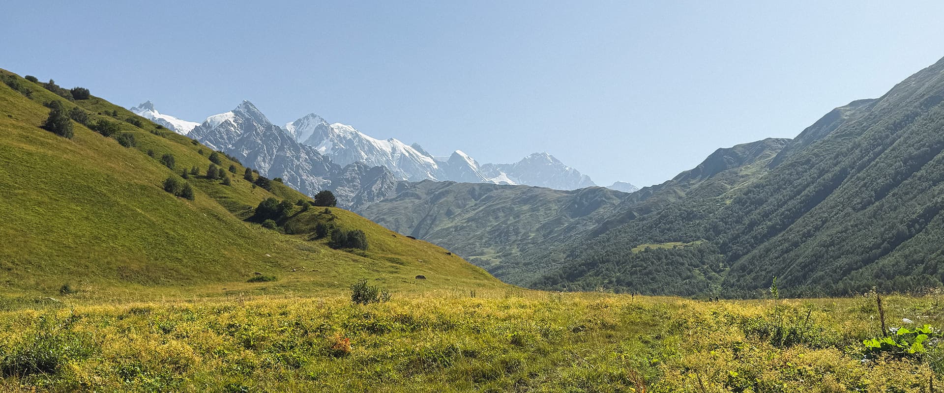
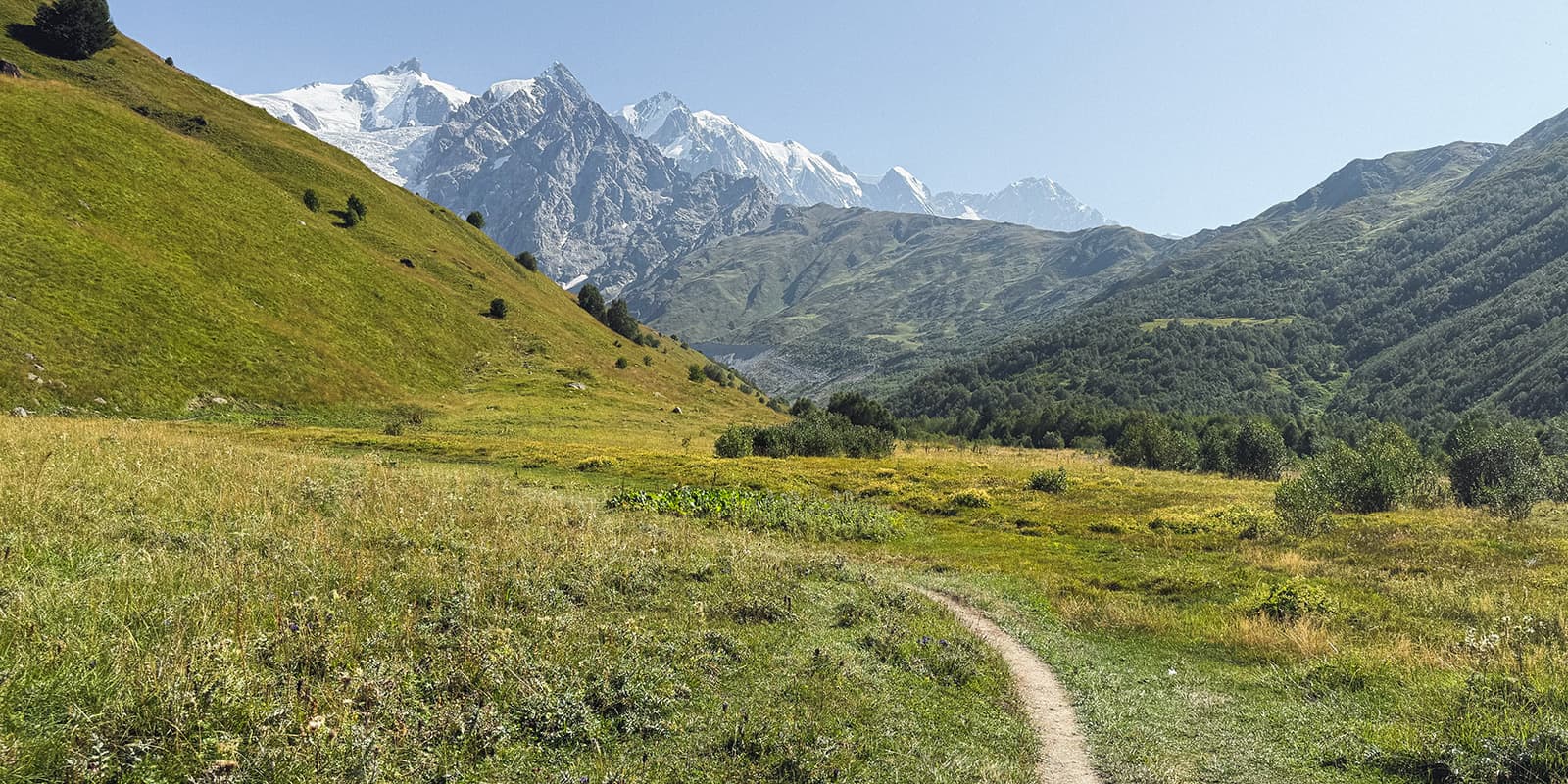
Stage three is the longest of the trek. The signs will point you toward Iprari, which is about one hour before Lalkhori. However, there aren’t many guesthouses in Iprari, so most hikers end up in Lalkhori. Start early to beat the heat in the valley. You’ll hike on a very gradual incline for about 1.5 hours before you reach the river. Here, there are men with horses for hire to cross, which we found to be a good option to avoid any accidents, as the water is glacial runoff and flows very fast. Once you cross the river, you’ll begin a 500M ascent to the Chkhunderi pass (2655M) with the best views of the entire trek. It’s steep, but there are some shaded sections, and you’ll sometimes have the breeze from the Adishi glacier to cool you.

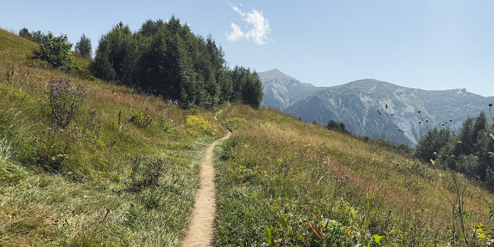
Once you reach the top, you’ll have a few options to climb further for more views or to begin your descent. This is the most spectacular section of the hike, so take your time here! Once you’ve soaked it in, you’ll descend toward Lalkhori on single-track paths. About 1.5 hours before you reach the village, there will be some cafes with snacks and cold drinks as a treat! We stayed at Guesthouse Robinzon in Lalkhori and thought it was great: comfy rooms, delicious food, kind hosts.

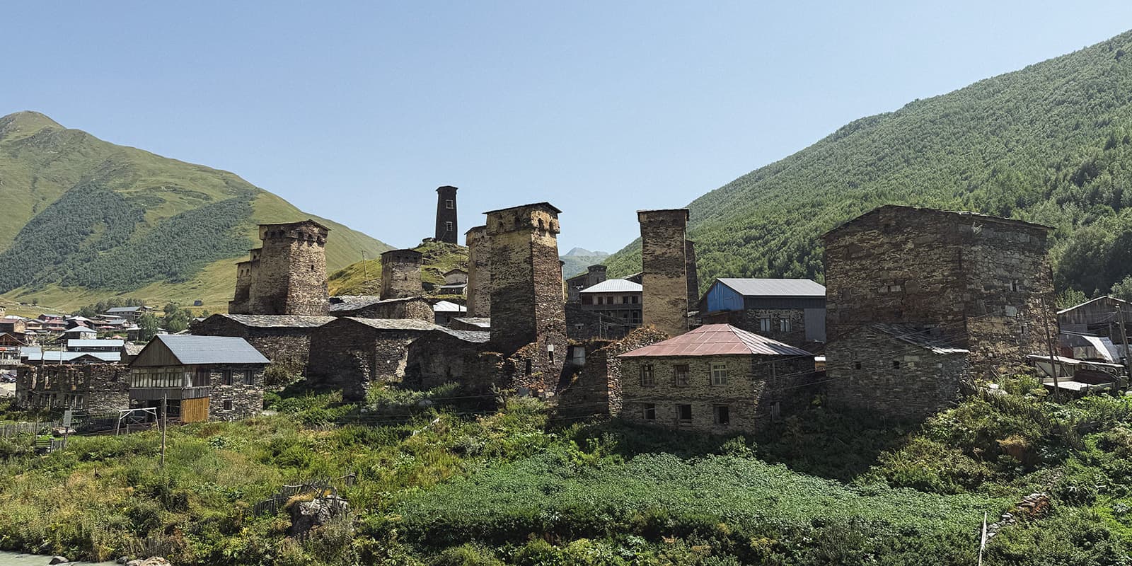
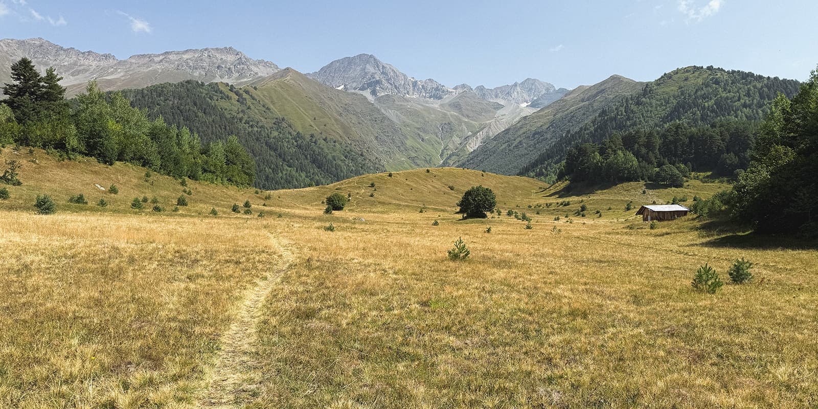
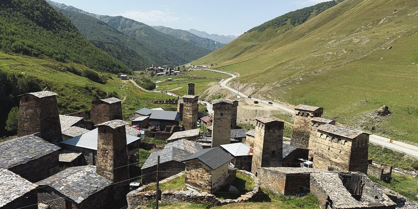
The final stage has a few options to reach Ushguli. We hiked up about 350M to reach a single track and avoid road walking. The path was forested and easy, with some small, wavy hills after the main ascent. You’ll have some final views before you’re led back to the road for the final 45 minutes into Ushguli. Look out for the trail that’s directly above the road on the left side for the most part of this! Ushguli is very special, with so many of the old structures still standing. You can even climb to the top of the Queen Tamar Tower on the hill once you arrive for final views of the region.

Stages

Hiking from Mestia to Ushguli can also be sped up to be hiked in 3 days instead of four. Usually, to do this, people combine the first two days, sleeping in Adishi on the first night. It’s possible, but it will definitely be a long, much more strenuous first day. If you have the time, we enjoyed splitting it up and found it more manageable.

4-day itinerary for the Svaneti Trekking

Stage 1:

Mestia – Zhabeshi, 16 km | 9.9 mi

Stage 2:

Zhabeshi – Adishi, 10 km | 6.2 mi

Stage 3:

Adishi – Lalkhori 19 km | 11.8 mi

Stage 4:

Lalkhori – Ushguli 10 km | 6.2 mi

Accommodations

Most people stay in the guesthouses that are so common along the trek. However, it is still possible to wild camp if you’re determined to do so! We saw lots of great wild camp spots as we hiked. The only thing to keep in mind is food. There are not many (if any) markets, so you will need to carry food for the whole way.

If you choose to stay at guesthouses, you’ll likely want to book ahead. This will secure you a bed at the top-rated ones, although there will likely be plenty of options when you arrive as well. The guesthouses provide dinner and breakfast for a separate fee. Most stays were about 100 GEL per person (about 30 euros) as of 2025, including both meals.

Best time of the year

The best time of year to hike in the Svaneti is from late June through early September. The trek goes by the Adishi glacier, which means that the temperatures can drop at night! However, it stays relatively warm/hot throughout the season during the days. The trek isn’t technical and doesn’t go above 3000 meters, so you can hike snow-free into September. You’ll also need to check on the road’s accessibility to Mestia, as this is very weather-dependent as it gets colder.

Safety & Gear

The Svaneti Trekking is a great hike to prepare for since you won’t need to bring much! As always, it’s important to bring a strong base kit with comfortable, weather-resistant clothing, good shoes, and plenty of water and snacks. Other than this, sun protection (hat, sunglasses, sunscreen) and a basic first aid kit will be helpful.

One river crossing after Adishi can be very strong and deep, going up to waist-high for many hikers. This can be tricky, and usually men hang around the river with horses that can take you across. We did this and found it to be a viable option for staying drier than if we had waded across on foot. This is your choice, but be smart and assess how fast the water is flowing and your comfort levels before making a snap decision.

Difficulty

The trail is listed as moderate for the more strenuous climbs sprinkled throughout the way. While the days are short (sometimes only 10km), you’ll find that 2-3 hours of that is spent on an incline. It’s important to prepare mentally, fuel and hydrate well, and adequately prepare for the amount you’ll sweat as you hike uphill! Otherwise, the trek is not technically difficult and is okay for new or inexperienced hikers ready for a challenge.

Good to know

The Svaneti Trekking is poised to see an uptick in hikers again in the upcoming seasons. Before COVID-19, 100-150 hikers started each day. Now, we estimate it is at about ~50-75 hikers per day. However, we’re seeing the trek regaining popularity each season.

To travel to the Svaneti region, take the train from Tbilisi to Zugdidi and then a Marshrutka (mini-bus) from there to Mestia. The train is comfier and almost the same price as taking a Marshrutka the entire way. And if you’re looking for even more comfort, a first-class ticket on the train is only a few euros more and makes for a very quiet ride.

For the return trip, the best option is to take a shared taxi to Mestia from Ushguli. The ride takes ~1 hour, and then you can catch a connection to wherever you want from Mestia.

route
point-to-point
highest point
2710m (8891 ft)

Want to submit a trail or make this page more complete?

Always read the disclaimer

Terms of Use: important to all visitors on this website. We strive to publish high quality content and information on this website. However it’s always possible that we’re missing out on some crucial information. In spite of the fact that this route, associated GPS track (GPX and maps) were prepared under diligent research by the specified contributor and/or contributors, the accuracy of such and judgement of the author is not guaranteed. Therefore, hiking-trails.com and contributors are in no way liable for personal injury, damage to personal property, or any other such situation that might happen to individuals hiking or following this route. Should you choose to hike this trail, this is always at your own risk. Check out our guidelines for safety hiking and Leave No Trace principles at the hiking 101 page.

Download GPX

Join the community!

Login or create a FREE account 😊

With an account you can:

Download GPX files

Pin trails to your wishlist

Mark trails as hiked by you

Rate hiking trails

Comment on trails, blogs and gear reviews

Happy trails!
Login

Don't have an account yet? Register here